Last week I was back on the Appalachian Trail (AT). I was hopeful. I was excited to be back on the trail. I was looking forward to seeing and experiencing all the AT and Maine had to offer. Let's see what actually happened.
 |
| Crossing the Androscoggin River. |
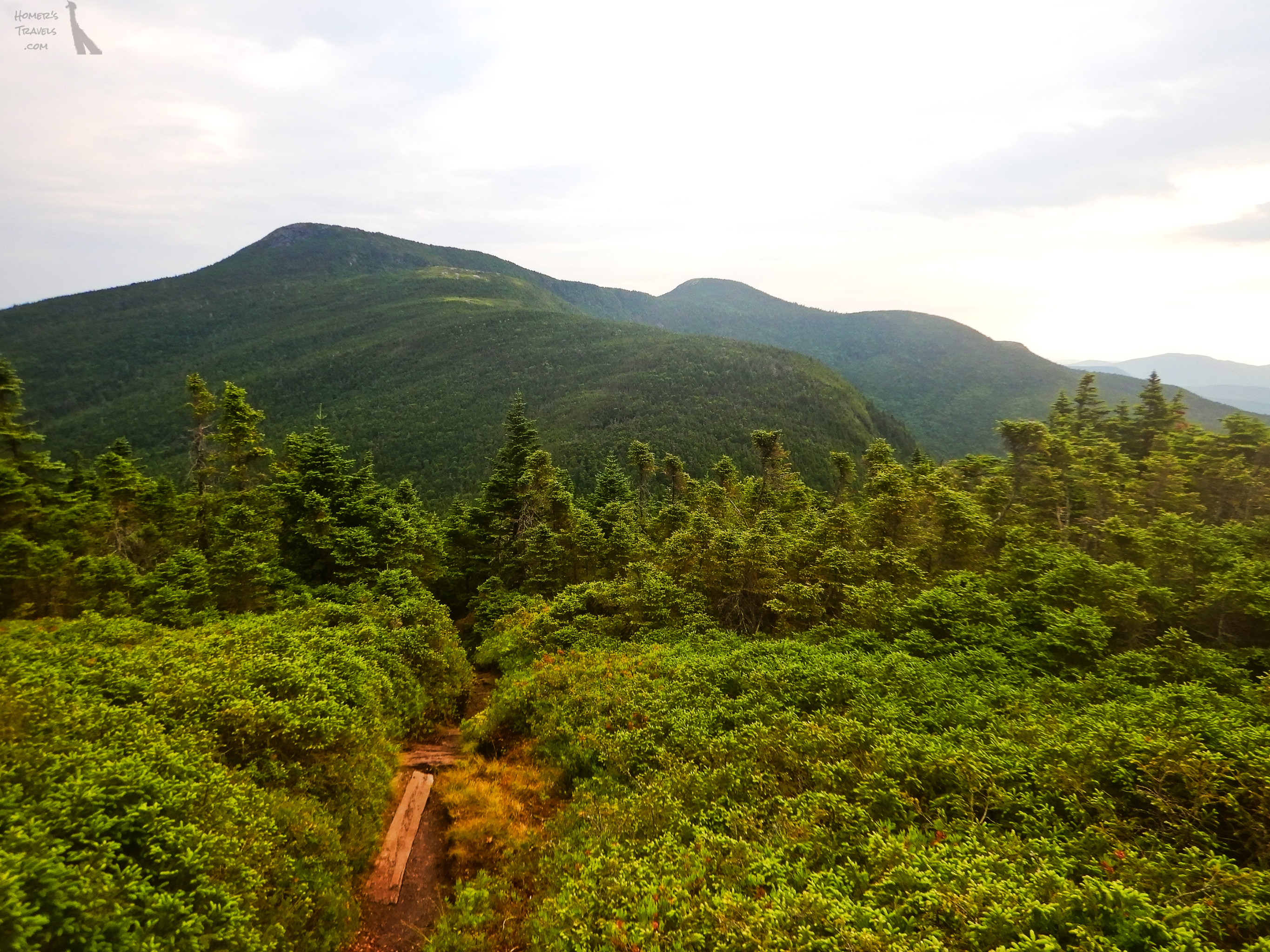
The trail started out similar to how I remembered it: a little rocky, a little rooty, not too difficult. That changed quickly. The rocks and roots became more numerous. I was slowed down quite a bit but it was still within my AT hiking experience. Near the top of Flat Mountain the views reminded me of what I enjoyed the most about AT. The weather was perfect and the sky was blue and the mountains went on forever. I was also starting to meet other hikers, both south bound (SOBO) and north bound (NOBO).
Not far from this first summit I passed by the 1,900 mile (3,057 km) mark. If I'd continued back in 2019 this would have gotten me exited. This time it didn't have the meaning it would have had.
 |
| It started out so innocent looking. |
Despite all the foot staring I still noticed the views at Page Pond and the summits I crossed on the trail. This first day was a preview of what was coming ahead in Maine and I couldn't wait.
When I reached my goal for the day, Gentian Pond Shelter and Campsite, I was exhausted. I know I had long, tired days in the south but this felt different. This was beyond normal exhaustion. I could hardly walk. I was too tired to do anything. I tried to make a meal but that didn't go well as I'd rather just lay on the floor of the shelter and moan.
 |
| Page Pond. |
 |
| My first day. 11.7 miles (18.8 km) |
Day 2 - Normally I was the first to get up. The Sun was rising at 5:15am so I saw me getting up soon after. That didn't happen. I stayed in my sleeping bag until other people got up at 5:40am I ate breakfast, packed up my gear, and headed out to my next goal around 9.6 miles (15.4 km) away. Between me and that goal were Mount Success, Mount Carlo, and several versions of Goose Eye Mountain (west, east, north).
 |
| Gentian Pond in the morning sun. |
 |
| Mountains as far as you can see. |
 |
| My last state on the AT (#14) |
With the decision to stop at Carlo Col Shelter, I missed my goal of the day by over 4 miles. This was not a good sign and I decided to get off before Andover at Grafton Notch. I figured I could get there in two 7 mile (11 km) days.
That night I was joined by other hikers and a gaggle of fifteen plus pre-teen French speaking school girls (I presume they were from Quebec).
 |
| My second day. 5.2 miles (8.4 km) |
Day 3 - Over the past few days SOBOs kept mentioning the Mahoosuc Notch and the Mahoosuc Arm. I looked it up in my guide book and saw the description (Not sure how I had missed it during my planning). It said: "Most difficult or fun mile of the the AT. Make way through jumbled pit of boulders." *sigh* My goal for the day had been a campsite between the Mahoosuc Notch descent and the Mahoosuc Arm climb roughly at the 7 mile point. I changed my goal to make it easier.
 |
| Mountains, trees, and bogs. |
I looked at the miles ahead of me and decided, instead of the two sevens I'd planned, I would do three 5 mile (8 km) sections instead. My restriction was food but … I wasn't doing a very good job of eating all my daily food so extending this section to five days instead of four wasn't a problem.
 |
| Did I hike over there … I think so. |
I arrived at the shelter at 12:30pm and just slept and forced myself to eat all afternoon. Forced because I had zero appetite … no hiker hunger.
A SOBO stopped here for the evening too. He talked about how beautiful Maine was and how much he enjoyed it. All I could think was how bad my body felt and wondered just how deep of an exhaustion a person could bear.
 |
| My third day. 4.4 miles (7.1 km) |
Day 4 - I woke up in a mild panic. I'd been dreaming of going through the Mahoosuc Notch and falling to my doom. Not a good way to start your day. I had two days to go to get off the trail and my subconscious and conscious minds were both concerned about getting off alive.
 |
| Surprised they actually gave us rebar steps. |
To get through this part of the AT it is best to put your poles in your pack since you will need free hands to climb. I put my poles away and started rock hopping until I caught up with a NOBO from Georgia named Trouble. We talked a little while we slowly made our way up, over, under, and around large boulders. We both said it was nice to have someone to do this part with so there was someone to call 911 if the other got injured.
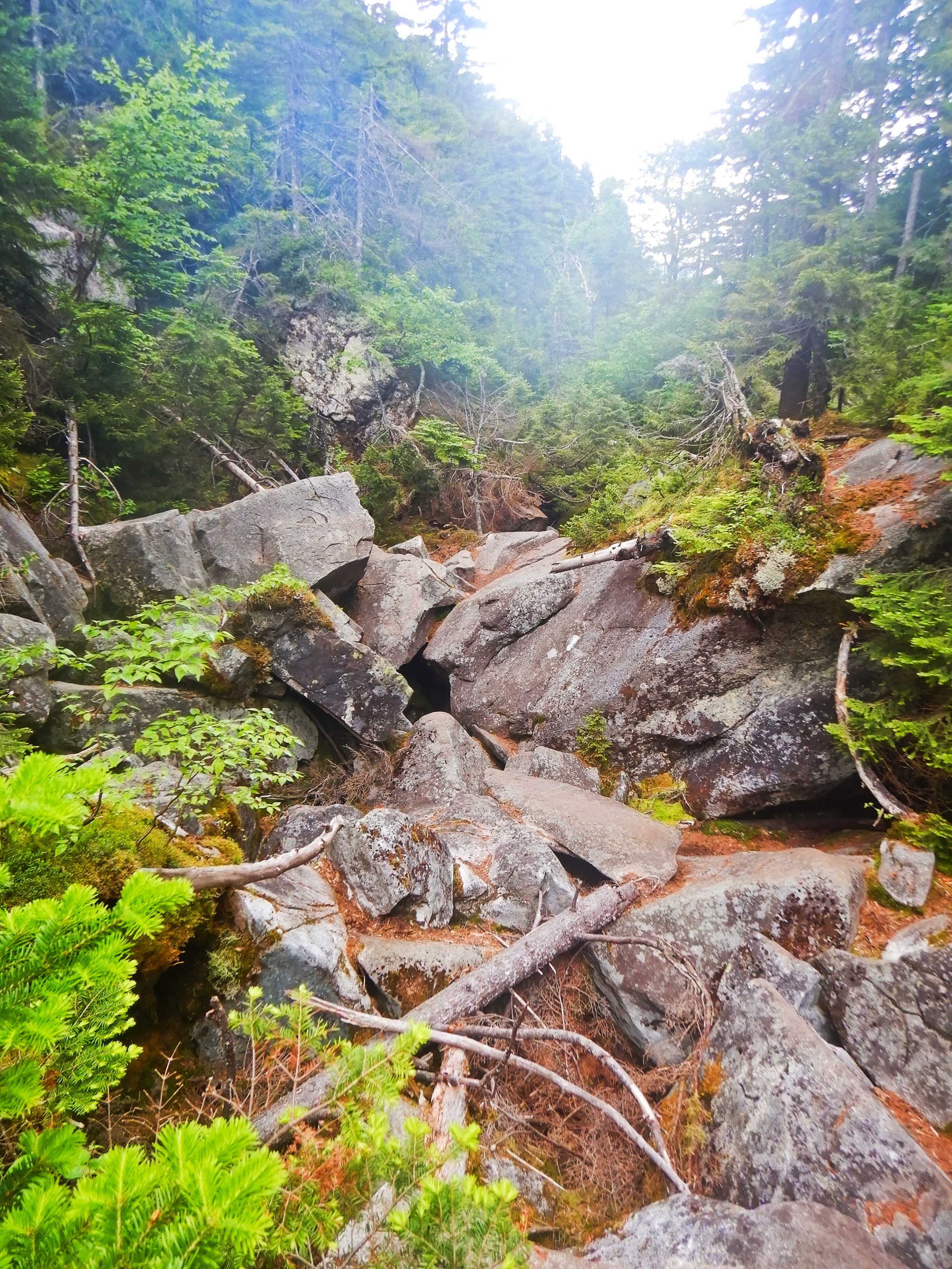 |
| The start of the boulder jumble of Mahoosuc notch. |
Despite the potential danger, the rock hop was pretty cool. Between some of the larger boulders you could still see ice and snow. When you walked by cave-like openings it felt like you were walking in front of an air conditioner. We stopped at an accessible stream between the rocks and had our fill of water so cold it almost gave us brain freeze. Was it difficult? Yes, this wasn't hiking, it was rock climbing. Was it fun too? I'd have to say yes. One thing I am sure of … I would never try to do this in the rain.
 |
| The arrow says go in but we climbed around. |
Trouble and I arrived at the Speck Pond Shelter and Campsite soon after. Another hiker showed up and briefly disappeared. When he reappeared his hair was wet. Apparently he likes visiting ponds. He likes to put on goggles and stick his head in the ponds he visits to see if there is anything interesting. He then moved on ... I presume to another pond to stick his head in.
Having someone with me through this section helped a lot. Trouble was continuing on to Grafton Notch. I was too tired to continue on and spent the night in the shelter. We thanked each other and said our goodbyes. I think she will make it to Katahdin.
 |
| My fourth day. 5.1 miles (8.2 km) |
Day 5 - So … this four day stage turned into a five day stage and covered 10 miles (16 km) less than I'd planned. This didn't go as I expected.
 |
| Speck Pond. |
 |
| On top of Old Speck Mountain. |
 |
| My last white blaze. |
My shuttle pick up time was at 2:00pm and I was there at 11:30am. I sat with some SOBOs and told them about the Mahoosuc notch coming ahead for them. It was more of a "It's not so bad" talk. They were all young and I was feeling old.
My shuttle picked me up early just before the rain returned and I was dropped off in Gorham.
This … whatever this was … was over.
 |
| My last day on trail. 4.6 miles (7.4 km) |
Total Distance*: 1,927.0 Miles (3,101.2 km)
Section Distance: 32.0 Miles (51.5 km)
Section Elevation Up: 11,632 ft (3,545 m)
Section Elevation Down: 10,778 ft (3,285 m) |
.jpg)
No comments:
Post a Comment