Homer's Travels: April 2019

Friday, April 26, 2019

Appalachian Trail: Nantahala Outdoor Center To Fontana Dam

UPDATED 10-18-2020

Note: I replaced a defective cable and now have GPS maps.  I have updated the last two posts with their maps.


A river winds through a valley.
One thing I like about the Appalachian Trail (AT) is how primitive the trail is.  Despite the thousands of people who hike the trail each year, especially in the south before most thru-hikers give up, the trail is still a narrow winding path with minimal markings.  On the AT you can forget who you are and be anywhere and anywhen you desire to be.

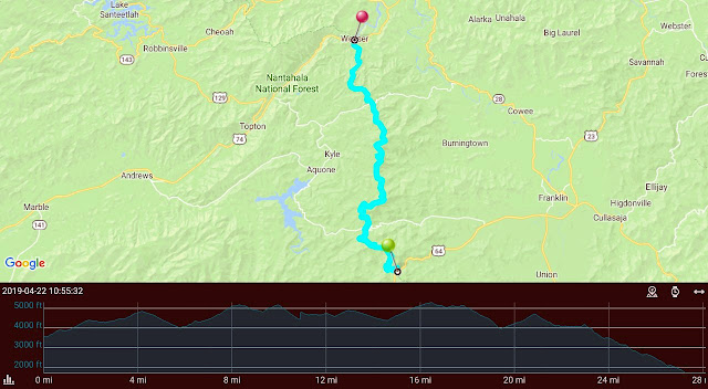
Day 21 - Today hiking out of Nantahala Outdoor Center (NOC) was brutal.  Up, up, and up some more. After topping Swim Bald I took an hour rest break at Sassafras Gap Shelter.  The rest helped a little but the climb to Cheoah Bald afterwards was still tough and the drop down to Locust Cove Gap seemed never ending.

Ha Ha … Very funny.
I suspect my problem was not enough calories while I was at NOC.  The over four thousand feet of climbing probably didn't help much either.  Oh, and altitude certainly played a role too.

I have to admit I have been spoiled staying in shelters.  They are so much more comfortable and convenient. I considered going to the next shelter after my planned goal but that would be a 11.7 miles - a distance I could do but I'm not sure if I should do. I set up my tent. I was there with four or five other hikers.

Day 22 - I woke up to a busted zipper on my tent's rain fly.  I also saw my self-standing modification also came apart. The modification can easily be repaired.  The rain fly not so much. I stopped at the next shelter for a rest and to call my tent manufacturer.  I was lucky that I'd purchased the tent straight from the manufacturer so they knew when I'd purchased it. Originally they wanted me to send a picture but after explaining my poor cell reception to them they were very nice and decided to send a new rain fly to Gatlinburg, TN for me to pick up.
Today was not as bad as yesterday but there was a part a lady had warned me about called Jacob's Ladder.  It went straight up the mountain so I went up the mountain … slowly.

My original stop for the day was Cody Gap campsite but when I got there I noticed that it was mostly downhill to the next shelter.  Mostly because the Appalachian Trail is never all up or all down. I'm glad I moved on as I felt pretty good once I arrived even though it was an 11.7 mile (18.8 km) day.  The push today means a shorter day tomorrow and more time in the Fontana Dam area for my next nearo and zero days.

The tree loves Hogback Gap.
At the shelter I met Pace Car who is nursing a sore ankle and several others who pushed long days to Fontana including Mad Max, Two Stick, and Double-D.
Days 23 & 24 - Wow! Three weeks on the trail. I hustled out of the rather stinky shelter (dirt, dust, and critter droppings) and headed to Fontana Dam. After an initial climb the trail turned down for a looong time.
I reached my destination, the Fontana Dam Shelter known as the Fontana Hilton. On the way down the hill I decided to splurge and get a room in the Fontana Village Lodge. It was Thursday and still early in the season so getting a room wasn't difficult. It would be nice to eat some food, spread out on a real bed, do laundry, and maybe soak in the bathtub.

I walked from the Shelter to the Dam where they had showers. I took a shower and put clean clothing before I called for the Fontana Village Lodge courtesy shuttle.
I picked up my food package I'd sent myself from Franklin and a replacement cable for my GPS the Wife sent me. I spent the afternoon updating posts, sorting out food for the next four to five days of hiking. Sorting food and other logistics has become a big part of my in-town time just like finding and filtering water is a big on-trail chore each day.

I bought an M&M cookie ice cream sandwich in the camp store. As I was eating it an M&M popped out and landed on the ground in front of a bench where a couple hikers sat. I thought about picking it up off the ground but one of the hikers said "If you're not going to do it …" and popped it in his mouth. That is one of the stories I heard on the trail: How do you tell what kind on hiker a person is? A Day hiker would ignore food on the ground, A Section hiker would pick it up and eat it. A Thru-Hiker would pick it up, eat it, and dig around to see if there is any more.

I had a great meal at the bar and a couple mediocre meals in the too frou-frou resort restaurant. The claim to fame for this resort is the winding road called the Tail of the Dragon. Car and motorcycle makers hold conventions here and demonstrate their vehicles on the tough winding curves of the road.
Today I will be eating breakfast, doing last minute laundry, and moving to the Fontana Hilton where I will spend the night before tackling the Great Smokey Mountains.

Pictures can be found in my 2019 Appalachian Trail Google Photos album.

Total Distance: 171.60 Miles (276.16 km)
Section Distance: 30.14 Miles (48.50 km)
Section Elevation Up: 7,677 ft (2,340 m)
Section Elevation Down: 7,592 ft (2,314 m)


Monday, April 22, 2019

Appalachian Trail: Franklin, NC To Nantahala Outdoor Center

UPDATED 10-18-2020

A thought before I talk about what I've been up to on the Appalachian Trail.

Before I reached Unicoi Gap and Hiawassee where I ended my first attempt two years ago, there was always a little evil voice in the back of my head saying that it was ok to quit again. After leaving Hiawassee the voice has lost its power and fades a bit more everyday. Yes, on tough days I wonder what the heck I'm doing but I no longer consider quitting. I just want to keep going.

Now on with the show …

Snow frosting the trees along the trail.
Day 18 - Curry decided to stay in Franklin one more day to see a band she liked and to let her knee rest some more. This would mark the end of my trail family.

I returned to the Appalachian Trail at Winding Stair Gap. When the shuttle arrived to drop us off it began to snow! Most of the day I hiked up hill in varying degrees of snowfall.  It was truly amazing. The snow stuck to the trees turning everything white. A gorgeous backdrop for my 11 miles (17.7 km) hike today. The trail itself always seemed to be free of snow.

When I arrived at Wayah Bald Shelter I was surprised to find it full.  This is the first time I arrived at a shelter and not got in. I think some of the hikers took a zero day in the shelter to skip the snow - a mistake in my opinion.

I found a relatively flat spot near the shelter and put my tent up in the falling snow.  Even though it was early I made my hot meal of the day and ate but it was so cold my hot meal turned tepid very soon.  I crawled into my tent and ate the rest of my daily allotment of food before hanging my food bag in a nearby tree.

Snow on my tent.
I crawled back into my tent early.  There wasn't anyone I knew in the shelter though I introduced myself to a few of the hikers.  I met Ambassador, Sunny and Letters.

It was going to be a cold night with probable subfreezing temperatures.  It was a night of many layers.

Day 19 - It didn't get as cold as I expected it to be which was a good thing.  I broke down my wet tent and headed out. The weather was weird starting with a lot of clouds.  As the trail climbed you entered a place where yesterday's snow was still hanging around but soon the higher temperatures made the snow and ice fall like a faux hailstorm.  The trail was soon covered in ice that crunched under your feet.

Panorama from the tower at the top of Wesser Bald.
Soon afterwards the snow was all gone and the skies cleared. From the watch tower on top of Wesser Bald you could see what I assume are the Smokey Mountains.  You could also see the snow on their peaks.

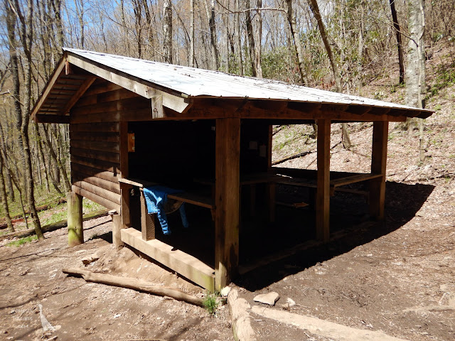
I pushed harder than planned today but it felt good though I'm glad I stopped at Wesser Bald Shelter. For those wondering what a shelter looks like:
Wesser Bald Shelter - three walls, a floor, and a roof.
Day 20 - Today was a short 6 mile (9.7 km) day into the Nantahala Outdoor Center (NOC). It's a favorite stop for hikers. They offer resupply, gear, food, zip lines, whitewater rafting, and kayaking.

I spent most of the day recuperating from my two long days, resupplying, taking in calories (i.e. eating junk food), and resting up for the climb tomorrow. My garbage bag had leaked inside my food bag over the last couple days so I rinsed the bag in the river behind the camp store. Somewhere here I bought an NOC magnet and promptly lost it.

With hindsight I think I probably should have moved on after I'd eaten and resupplied.


The hills and valleys are turning green.
Next stop, Fontana Dam and the entrance to the Smokey Mountains.

Pictures can be found in my 2019 Appalachian Trail Google Photos album.

Total Distance: 141.46 Miles (227.66 km)
Section Distance: 28.13 Miles (45.27 km)
Section Elevation Up: 5,806 ft (1,770 m)
Section Elevation Down: 7,962 ft (2,427 m)


Friday, April 19, 2019

Appalachian Trail: Hiawassee, GA To Franklin, NC

UPDATED 10-18-2020

The continuing adventures of Little Hill.
It's a tradition to have a trail name on the Appalachian Trail (AT).  The informal rule is that they must be given to you by someone else.  I got my trail name last week when, after explaining that I did all my training on three hundred foot hills, Curry said "That's a little hill." A week or so later the trail name seems to have stuck.

Day 9 - I left Hiawassee on the 9:00am shuttle.  I had a short hike planned for the day but it had some significant climbing.  It was cold, drizzly, and foggy most of the day.  More evidence of the near record moisture Georgia is getting this year.

The bright spot was when I arrived at a gap to find three old men offering up trail magic.  I'd missed my first two trail magics so I was grateful for the hot dogs, fruit, and cookies I received.  The roaring bonfire helped a lot on this chilly morning.

More and more flowers are making an appearance.
I arrived at Tray Mountain shelter and claimed a spot.  Rumor had it the shelter leaked during storms and a storm was on it's way.  I decided to stay though a lot of people moved on to the next shelter.

The hard wind and rain came in over night and the four brave souls in the shelter stayed nice and dry.   Rumors have not always been reliable on the AT.

Day 10 - For some reason I decided to push it on day ten.  I actually chopped a day off my plan.  I hiked 11.5 miles (18.5 km) to Dick's Creek Gap where I promptly ran into Crow and Curry.  I'd expected them to be at least a day or two ahead of me but here they were. They were heading out so they still were ahead of me but only by a half day.

My first snake of the AT.
From Dick's Creek Gap I walked the half mile to Top of Georgia Hostel.  Llama Mama and a few others I'd met along the way were here.  The hostel shuttled us back to Hiawassee so we could resupply.  I used some of the time to get all you could eat at Daniel's Steakhouse (the fourth time in a week).

The calm before the storm offered views.
Day 11 - The weather forecast was ominous for the next day.  My original plan had me staying at Blythe Gap campsite but heavy rain, wind, hail, and thunderstorms were coming in.  The weather was nice today though so I was considering pushing to the next shelter.

The border crossing.  Note Curry and Crow's stones.
The little blue fish is a hand blown glass fish being left
at each border crossing by another thru-hiker.
As I approached Blythe Gap I passed the sign marking the Georgia - North Carolina border.  My first milestone on the trail - a state border.

I left the border and on the way up the next mountain I caught up to Crow and Curry (!) and we finished the last couple of miles of the 11.8 miles (19 km) to Muskrat Creek Shelter.

Yep ... the weather was in the Sheeter.
Day 12 - The storm hit and boy did it hit hard.  It poured rain.  The Appalachian Trail Conservancy warned hikers to stay off trail so Crow, Curry, and I, along with several others, hunkered down in the shelter.  Honeybun (she'd bought a ton of honeybuns to take with her on her hike but they never made it out of the house having been eaten them all by herself) had spent a cold night on top of the picnic table but moved in the shelter when a few hikers decided to move on despite the weather.  It was boring and a bit cold but it did let my legs recover from the back-to-back eleven plus mile days I'd just done.

Taking a zero day at the shelter was the right thing to do.

A fallen tree, blown over in the storm, blocking the trail.
Day  13 - It was very cold this morning.  Someone said it was 16℉ (-8.9℃).  My food bag, which was hung in a tree all night, had ice on it and the cord was frozen stiff.  By the way, the bag is hung in a tree to keep it away from bears.  Shelters in North Carolina do not have bear boxes or bear cables so you have to hang the bags yourself.

Crow jumped up and ran around like a crazy man. His mom had bought his sleeping bag for him and, not knowing anything about sleeping bags, had bought a 70℉ bag.  This means it was only good down to 70℉.  He had tried to supplement it with an emergency blanket but that had held in all the moisture that his body gave off when you sleep (nearly a liter on average).  The result was a cold, wet sleeping bag and an even colder Crow.

It was so cold I packed my bag and left early so my hiking would warm me up.  I also had to make up the time and distanced lost during the zero day in the shelter.

A happy Shadow Walker makes an appearance on the AT.
A few miles down the trail, as I was heading down a mountain toward Deep Gap, I suddenly realized that I was F-ing Happy.  It's been a while since I've felt so happy.  I was almost giddy.  I think the rest and the energy from all the food I ate in the shelter made this long day easier (but not easy).

Crow left the trail and hitched a ride to Franklin.  Not sure when he will be returning to the trail (He didn't).

This was a 12.5 mile (20.1 km) day.  Curry joined me here with a few other hikers.

Day 14 - I decided to try to get as close to Winding Stair Gap where I could catch an early shuttle into the town of Franklin, NC.  The hike took me up the steepest rock climb yet to the summit of Albert Mountain.  It was a bit grueling but the rewarding view at the top was incredible.

I can see for miles and miles and miles ...
On the top of Albert Mountain is a fire lookout tower.  The room at the top was padlocked but you could still climb three stories to admire the endless view.  There wasn't a cloud in the sky and the mountains seemed to go on forever.  This tower is also very close to the 100 mile (161 km) hiked milestone.

The rest of the hike, while mostly downhill, actually went on forever.  I was exhausted when I got to the shelter.  Curry, who was going to the join me at the shelter, stopped at another one when her knee started bothering her.

The shelter was a little run down and the floor slanted a bit.  North Carolina needs to improve their shelters.

This was the second twelve mile day in a row.  Not wise on my part.

Day 15, 16 & 17 - I hiked the four miles to Winding Stair Gap and caught the 9:30am shuttle to Baltimore Jack's Hostel and grabbed a reasonably priced private room.

The Easter Bunny made an early appearance on the AT.
Curry arrived on the 11:30am shuttle.  Talking with her about her knees and looking at the weather we decided to take two zero days instead of one.  I think the ball of my right foot which has been bothering me the past few days agreed with the decision.  With the extra zero day I wiped out the extra day I earned by doing all the long days.

Crow was at Baltimore Jack's Place too so we chilled together.

Confederate statue in Franklin, NC.
Franklin turned out to be an awesome town to stop in.  Lots of history, nice stores for resupply, and nice people.  The Confederate statue in the downtown area is a reminder of where you are.

I spent some of my down time reevaluating my hiking distances before and through the Smoky Mountains.  I think I will add a few days to shrink down the miles per day.  It's nice to know you can do long days but I think it would be wise if I ramped up to those distances at a slower pace.

I found out that my next resupply stop did not have a lot of resupply available so I bought extra food in Franklin and mailed it to myself at Fontana Dam.  Turns out I should have done this with all my food resupply.

There was a cool rock/mineral store/museum not far from the hostel.  I purchased a small Buddha statue here.  Curry got some stones/fossils/native tools identified by the owner.

We will get back on the trail on Saturday which, sadly, will be a rainy one.

Here is a video taken by Curry while we were in Franklin.  After seeing this video again I realize now that Franklin was where my first and only real trail family formed and, sadly ended.

Pictures can be found in my 2019 Appalachian Trail Google Photos album.


Total Distance: 113.33 Miles (182.39 km)
Section Distance: 57.85 Miles (93.10 km)
Section Elevation Up: 13,792 ft (4,204 m)
Section Elevation Down: 14,374 ft (4,381 m)

Note: this map is missing some elevation data.

Wednesday, April 10, 2019

Appalachian Trail: Springer Mountain To Hiawassee, GA

UPDATED  10-18-2020
Day 1 - Mama's Taxi dropped me off at the Springer Mountain parking lot on Wednesday morning.  Mountain Squid, a trail volunteer, was taking people's names and handing out trail magic.

The first white blaze and plaque on the AT at the summit of Springer Mountain.
I headed the wrong way on the Appalachian Trail (AT) because I had to visit the summit of Springer Mountain, the official start of the AT, before I could head north.  This little backtrack added about a mile to my hike this day.

The weather was gorgeous and the trail was mostly downhill until I arrived at my stop for the night, Hawk Mountain shelter.

I met a few thru-hikers here that I would see along the way.

NOTE: I will use trail names when I can even though some of the names were bestowed after I actually met them.

Here I met Cloud and his dog Raindrop, No Heart (Yeah ... he was often heartless), Nightingale (caught singing in his tent), Crow, Curry (made curry her first night that was so spicy she couldn't eat it), Snowman, Kilroy, and Waka-Waka (he stuttered and had difficulty saying his home town ... and he like Fozzie Bear).

Unlike last time I ate all my food and I walked shorter stages.  This allowed me to reach the shelter/campsite early enough to get some rest and to socialize.  Socializing is the key to hiking the AT.  I often hike alone but being isolated at the end of the day can be soul crushing if it goes on for a long time.  A good laugh/story telling/commiserating session with a bunch of kooks like I ran into really can lift your spirits.

Day 2 - It turns out that I am the early riser of the group. I just can't sit around in the morning when there's hiking to do.  Like day one the weather was great.  I made good time.

An AT critter crossing my path.
The largest thing I've seen so far is a squirrel.
I arrived at Gooch Mountain shelter around noon and relaxed.  That is I relaxed until people arrived and asked me if I'd partaken in the 'hotdog lady's' trail magic.  It seems this nice lady had shown up at Cooper Gap after I'd gone through and was handing out free food and drink to the hikers.  Turns out the early bird doesn't always get the worm.

That night the rain came and I was glad to be in a shelter.

Day 3 - On day three it was a bit dreary and wet after the night's rain.  I passed a huge puddle.  It turns out several people including Waka-Waka, Kilroy, and Snowman had set up their tents where this puddle was and had been flooded out overnight.

Near the end of my hiking day I caught up with Curry and walked with her for a while.  Along the way she christened me Little Hill because of the little hills I trained on near my home in Nebraska.  We met up with Two Sticks (later rechristened Pack Flip - he put his pack on by flipping it over his head).   She was going to hike a long day up and over Blood Mountain.  I seriously considered going with her but, when we stopped at my original goal for the day I reconsidered and decided to stick to my original plan and camp at Lance Creek.  Looking back this was the right decision for me.  Curry and Pack Flip moved on.

A, so far, typical foggy day on the AT.
Met Cowboy, Josh, and Ryan along the way.  Poor Josh lost his tent poles so had to put his tent up with literally sticks and cord.  Fortunately for him it didn't rain this night.

This was the first time I'd ever put up my tent on this AT attempt.

Day 4 - It was another foggy, overcast day as I climbed up and over the ominously named Blood Mountain, the highest peak on the AT in Georgia.  Because of this there were no views this time and fewer people up top.  Climbing the mountain wasn't nearly as tough as I remembered it but going down was just as hard, if not harder, than I remember.

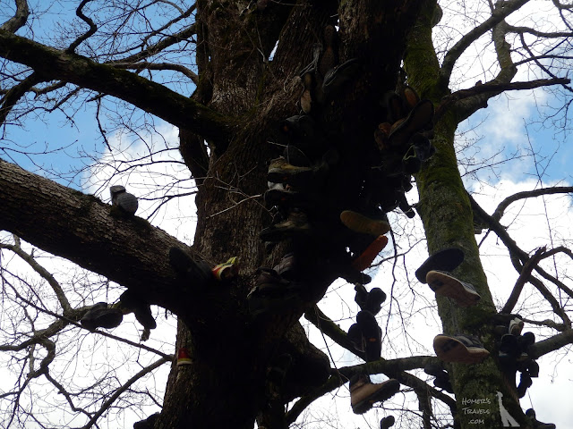
The Neel Gap shoe tree where quitters surrender their shoes.
I stopped at Neel Gap and Mountain Crossings outfitters.  I restocked my food and spent the night in the hostel.  Curry was still here.  The long day had did her in and she had reinjured an old knee injury but she continued on later in the day to a campsite four miles or so farther along.  The only person I knew in the hostel was cowboy.  A bunch of others went down to Blood Mountain cabins for the night.

I met Shark Chow here.  He is an ocean kayaker and a journalist.

Day 5 - This was the longest day on the AT so far.  It was nearly eleven and a half miles with a crap ton of ups and downs.  When I arrived at Low Gap shelter I was pooped.  Crow was here along with Llama Mama.  The whole family showed up here soon afterwards.

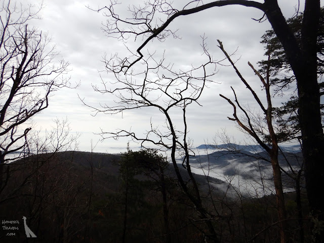
Some views today before the fog and clouds came rolling back in.
Along with Llama Mama I met Hershey Legs,  Eagle with his dog Camo, AKA,  and a strange one named Nemo.

Day 6 - the last whole day on the trail before my first break was a relatively easy one to Blue Mountain shelter.  It rained on and off this day and my rain coat got a workout.

Just love the stacked stone.
It was chilly on the top of Blue Mountain and people were showing up soaked.  Crow, No Heart, Curry, and Tortoise (I described her as only a section hiker and she took offense - oops) all tried to warm up a shivering Llama Mama.  We managed to get her out of her wet clothes into dry ones and Crow filled a bottle with hot water to use as a hot water bottle.

This was, by far, the wettest day so far.  Everything felt damp and wouldn't dry.

Days 7 & 8 - I left the shelter early at 7:30am and headed down Blue Mountain.  It wasn't raining as I'd expected it would be which made the wait for the shuttle at the bottom better.

Laundry, lunch, shower - these were the main tasks for the day.  I also wrestled with editing pictures and downloading track file from my GPS.  My file renaming and photo editing apps, which are great on my Chromebook at home, did not work properly on my tablet.  My GPS, which has worked great so far, stopped talking to my tablet.  I spent a few hours fighting with things that should have taken me less than an hour to complete.  *Sigh*

Today I'm trying to stay off my feet, which is turning out to be hard since I have to walk around town to resupply and get food to eat.  I resupplied at the local grocery store.  I only need two days since I will be resupplying at the Top of Georgia hostel/outfitter.

To my surprise Crow and Curry showed up at my hotel on day eight.  They pushed hard and got off at Dick's Creek Gap and came into town.  This made the last evening of my zero day fun.  We all went to the all you can eat Daniel's Steakhouse (My third visit there).

Tomorrow I get shuttled back to the trail and head back out.   Weather is supposed to be good the first day but rain returns.

This is a fairly long post but I haven't even tried to tell all the stories behind all the trail names or all the other stories heard along the AT.  If I did the post would never come to an end - and this is after only one week.

Pictures can be found in my 2019 Appalachian Trail Google Photos album.

Section Distance: 55.47 Miles (89.27 km)
Section Elevation Up: 10,983 ft (3,348 m)
Section Elevation Down: 12,395 ft (3,778 m)

The map for my first section of the Appalachian Trail
from Springer Mountain to Unicoi Gap (Hiawassee, GA).
NOTE: This will be the last cool map and graph until I figure out what's wrong with either the GPS or the cable. 

Sunday, April 07, 2019

Appalachian Trail Gear: The Nemo Hornet 2P Tent (And How To Make It Freestanding)

On my first Appalachian Trail (AT) attempt I slept in the Tarptent Rainbow.  I fully intended to use it again on my second attempt.  I was putting up the tent to clean it when I pushed the pole between the pole sleeve and the reinforcing at the end.  This was a minor issue since it could have been fixed for around $20.00 but, after looking at alternatives, I decided to buy a new tent.  The Rainbow was a nice tent but it had shortcoming.

My new tent I'm using on the AT now is the Nemo Hornet 2P.  '2P' means it's a two person tent but ... Nemo exaggerates.  It is mighty tight for two people - you would have to really like your tent mate.  For one person the tent is roomy though but not quite as roomy as the Rainbow.

The tent goes up in two stages - (1) put up the tent, (2) put up the rain fly.  This is fairly standard for most tents but I have to admit I was used to the tarptent method of putting the tent and fly up simultaneously.  This allowed you to put the tent up in the rain without getting the interior wet. I'm not sure if I can put the Hornet up in the rain without some water getting inside.

Having said this, the Hornet is really easy to put up.  Deploy the tripod pole, attach the pole to the tent corners, clip the tent to the pole.  Throw the fly on and attach the fly to the corners and you are done.  In calm conditions I think I could get it up in a minute or less.

The Hornet weighs about the same as the Rainbow.  On warm days the fly can be left off to allow maximum ventilation and a clear view of the stars (a big plus in my book).  The Hornet's ventilation is much better than the Rainbow.  Lastly, the Hornet has two vestibules versus the Rainbow's single vestibule.  This allows you to easily stow gear in one vestibule, protected from the elements, and have another vestibule to enter/exit the tent.  Two vestibules also means you can open both flaps to let air flow through the tent on hot nights.

I had to make one modification to the tent.  The Hornet is considered a semi-freestanding tent.  Two of the ends of the tripod pole attach to the corners of one end of the tent using Jake's foot connections (a round ball end on the pole pops into a socket attached to the corners of the tent - easy to put together and easy to take apart).  The third leg of the tripod pole goes through a grommet on the middle of the other end of the tent.  To completely deploy the tent you have to stake out the corners of the 'grommet end' of the tent.  I prefer a fully freestanding tent so I put on my thinking cap and figured out how to make it freestanding.

A loop of cord and a cord lock through
the grommet tab of the tent.
First I examined the Rainbow.  The Rainbow is freestanding using hiking poles to keep the tent ends spread out.  I took a pole and wrapped the guy lines around the handle and tip of the pole.  I pulled the fly cords taught and saw the hiking pole ride up the tent pole - not good.  The Rainbow has a Velcro strap to hold the hiking pole in place.  I considered the issue a bit and came up with a simple cord and cord lock solution.

I ran a piece of cord through the grommet tab, fed the ends of the cord through a cord lock, and tied the ends of the cord together into a knot that would keep the cord lock from slipping off.  The loop has to be large enough to allow a hiking pole to slide through it including the joints (my poles have quick locks).

The hiking pole cinched down.
To make the tent freestanding, pitch the tent and fly as normal.  Slide a hiking pole through the added loop until the loop is roughly halfway along the pole.  Use the cord lock to cinch the hiking pole down.  At the pointy end of the hiking pole wrap the tent line around the pole a couple times.  Hook the fly loop cord over the end of the pole (See here).  At the handle end wrap the tent line around the hiking pole handle.  Make a larger loop in the fly cord by feeding the cord through the loop (See here) and loop it around the handle (See here).  Pull the fly tight.  The tent is now freestanding and can be easily lifted to move the tent to another location.

I will follow up this post once I've had some experience putting the tent up in the rain.

Friday, April 05, 2019

Appalachian Trail Gear: The Little Deuce Scoop

I mentioned in my last post that I was rethinking what I packed and what I left home.  Another thing I did was to look for lighter alternatives for things I have to carry.  One of these alternatives made me chuckle.

The thing being replaced was the plastic trowel I used to dig cat holes (i.e. places to take a dump).  The one I had, a very standard orange plastic Coghlan's Backpacker's Trowel, weighed in at just under 2 oz (58 gm).

I did a little searching and found a much lighter, and very appropriately named, replacement.

My replacement cat hole trowel.
Yes ... it is called the Deuce #2.  I couldn't help chuckling as I ordered it on Amazon.

My new trowel, including a tiny carabiner to hang in from my pack, weighs in at 0.67 oz (19 gm), less than a third of my old one.  Over two thousand miles, little savings like this mean a lot.

I'm not so sure how much it will get used as most shelters have privies but if you find yourself miles from the nearest privy and just have to drop a deuce, The Deuce #2 will git-r-done.

Thursday, April 04, 2019

Appalachian Trail: A Second Try ... A New Plan

Some of the more observant readers may have noticed the addition (or re-addition actually) of the Appalachian Trail tab next to the Magnets and Camino tabs.  As soon as I decided I would make a second attempt on the Appalachian Trail (AT) I started making a new plan.

The new plan builds on the first with the addition of lessons learned on my first attempt.  I was only on the AT for six day - I walked off the trail on the seventh day - but I learned a lot about weight in that week.  So, this time around, I looked at ways to shave weight off my pack.

My first planning attempts were zero day centric (a zero day is a rest day with zero miles walked).  I thought I would hike, on average, six or seven days and then have a zero day in a town.  The problem with this is that food weighs a lot.  With up to 15.75 lbs (7 kg) of food, along with a few other things I didn't need, I ended up with a 45 lb (20 kg) pack on my first AT attempt.

A more reasonable amount to pack in the bag.
(See here for first attempt packing)
My new plan is resupply centric first and zero day second.  As I planned I looked for easy towns to stop at that had grocery stores/outfitters where I could buy food.  If there wasn't a convenient place I found a convenient post office where I could resupply by mail.  I managed to get the resupply period down to between three and four days.  This means I will be carrying less food - up to 9 lbs (4 kg) less.  Along with the other things I have scratched from my list I reduced the weight of my pack down to 36.3 lbs (16.5 kg).  I was aiming for 35 lbs but ... I was close and it it definitely better than 45 lbs.

What 'other things' did I get rid off you ask?  Things like packing two shirts instead of three.  Do you really need ten Band-Aids when five would suffice?  Extra carabiners?  Do I need a flint and steel if I have a lighter?  Do I need a fancy nylon zipper bag when a Ziplock baggie would be enough?  All these, among many others, are little things individually but, when I cleaned out my pack at Neels Gap last time I sent nearly 6 lbs (2.7 kg) of unneeded stuff home.  Also these are non-consumable mostly so, while food diminishes in weight as you eat it, these items continue to be dead weight.

A slightly more compact setup this time.
(See here for first attempt packing)
Along with reducing my weight by changing the resupply plan, I also shortened my miles for the first month.  Last time I aimed to average 10 miles (16 km) a day for the first three or four weeks.  This time I am keeping the average below 8 miles (13 km).  This will make my start easier but I will have to pay for this ease with harder (i.e. longer) stages later on.

Less weight and shorter initial stages will make the start of my AT more doable for me.  I'm looking forward to being less exhausted at the end of the day allowing me to be more engaged with the other hikers I encounter along the way because it's not the trail but the people you meet along the trail that makes the AT experience.

Wednesday, April 03, 2019

Appalachian Trail: "Once More Unto The Breach"

It started early in 2018, a year after my failed attempt at an Appalachian Trail (AT) thu-hike.  Through most of 2017 I had struggled with depression, regret, and not a little bit of embarrassment.  In spring of 2018 the depression lifted a bit and the regret asserted itself.  I began to wonder if I should try the AT thru-hike again.

I didn't share this thought with anyone.  I wanted the idea to ruminate a bit to see how I felt about it.  I started biking again in late April 2018, often daydreaming about the AT as I rode .  One day on a bike ride, as I pondered the trail, I realized I was smiling.  This was significant for me - before my first attempt I often doubted if I was doing the right thing.  Now the thought of a second try made me smile.

The Wife and I were sitting watching TV one evening when the Wife asked if I should go out for another long hike.  I think she registered the funk of indecision I was in about a second attempt.  I told her my thoughts of a second attempt on the AT.  She was incredibly supportive.  I asked her not to share my decision until I felt more certain.  I kind of felt that talking/posting about it would jinx it somehow.

I started planning soon after.  I rode my bike more and I started hiking with a pack to prepare.  I soon realized that I was not getting any younger so I made a decision ... It would be in 2019.

As you are reading this post, assuming you are reading soon after it's publishing, I am not far from Springer Mountain - the southern terminus of the Appalachian Trail - and I am heading north.

Posted this picture before my first attempt.  This time things will be different.
This time things are different for both the Wife and I.  Last time the Wife was anxious about me doing this.  Strangely enough, I had the exact same feeling except with the emotional anchor of depression added on.  This time both the Wife and I are excited.  I feel more ready than I did last time.  I have a better plan than last time.  I have learned the lessons of last time.  I feel ready for the adventure ahead of me.

"Once more unto the breach!"
- Shakespeare's play "Henry V"          


P.S. If you are following this adventure on Facebook, you may want to like/follow my Homer's Travels page to get posts as they are published.  Better yet, follow @HomersTravels on Twitter.