Homer's Travels: August 2019

Thursday, August 29, 2019

Appalachian Trail: Great Barrington, MA To Bennington, VT

🐻 x 6
UPDATED 11-21-2020

The past six days have felt better despite the trail not being any easier.  I was overrun by a north bound bubble just to be left behind a few days later.  I met people who motivated me and I saw awe inspiring views.  It also helped that another state was left in the rear view mirror and another milestone was crossed.

Day 142 - A trail angel name Joe took me back to the Appalachian Trail (AT) and I headed northward once again.  The trail crosses roads occasionally and at some crossings there are parking lots for hikers.  At one crossing I came across a couple from Michigan who had driven out to give trail magic to their southbound daughter and other thru-hikers.  I sat for a while had a couple bananas, an apple, a pudding cup, a Gatorade, and a handful of Oreos.

I was joined by a northbounder from Alaska called Turtle.  When I left she left too and we hiked the rest of the day together.  She had had a rough time lately like I've had with thoughts of quitting.  We spent the next four or five hours talking about our AT experience, the Camino (she'd walked it a few years ago), and about the people we'd met on the trail.  Turns out we had a lot of hikers in common.  She told me a harrowing story about a guy who stalked her along the AT.  A hiker named Strider (I met him back in the Smokies) scared the guy away.  She was very talkative and thoughts of quitting were soon crowded out.

We arrived at our campsite for the evening.  The place was packed with Yale orientation students and nine other north bound thru-hikers (Clemson, College, Dirty Dan, Swish, Papa Rojo, Bear, Teeter, Chickadee, and Pots n Pans).  I was tired and I climbed into my tent early.

We passed several ponds along the trail.
Day 143 - I was the first to leave the campsite.  Turtle, also an early riser, caught up with me soon after and we hiked together for the next eighteen miles.

My butt was dragging today while Turtle felt good.  When we arrived at the October Mountain Shelter I stopped for the day.  Turtle still felt good so we said our goodbyes and she moved on.

Grandma, Ramblin' Man, Choo Choo, and Chili came, ate, and went on.  We chatted a little as they ate.  I was in a bubble of new and old thru-hikers.  I would be in the bubble only a few days - a continuation of the pattern of my AT.

The flowers along the trail are constantly in flux.
Day 144 - I left the shelter alone and moved on.  The AT passes through the town of Dalton, MA.  It passes by a bar that was not open yet and an ice cream shop that was also not open yet.  *Sigh*. I found a sandwich shop that was open and had lunch.

I stopped at the Chrystal Mountain Campsite and chatted with a section hiker and Clemson before getting in my tent.  I was surprised by an overnight rain that had not been in the forecast.

Two days in a row I missed my chance for ice cream.
Day 145 - For the second day in a row the AT passed through a town.  Cheshire was a nice  town.  The AT passes another ice cream stand that, naturally, was not open yet.

On the way out of town I stopped at a convenient store and a Dollar General and resupplied for the next few days.

Leaving Cheshire meant scaling the highest mountain in Massachusetts, Mount Greylock.  I reached a shelter part of the way up and took a nap.  Since the shelter was only ten miles from where I'd started the day I continued up the mountain.  At the top there is a lodge with a bunkhouse.  I rented a bunk and ate an early dinner in their dining room.

At the top of Mount Greylock stands a war Memorial tower you can climb.  From the top you can see for miles and it was a clear day.  Around the summit hang gliders flew around as tourists watched from below.

The lodge filled up with rich retirees and yuppies.  I was the only hiker who stayed here.  This gave me mixed feelings.  It was nice to have time to see the memorial and enjoy the views but I missed being around 'my people'.   I think I should have pushed on to the next shelter.

The War Memorial
on Mount Greylock.
Day 146 - The day before was a shorter day and today was also a shorter day.  I climbed down Mount Greylock.  At Mount Williams I looked at the trail register and saw: "Keep going Little Hill. You got this. - Turtle".  This made me smile as I hiked down the mountain.

Once again the trail went through the outskirts of a town.  Where the AT passes through North Adams, MA there are no restaurants or stores but it does pass by an elementary school.  There is a trail log so you can leave messages for the students.

You leave town and climb up another ridge.  Along the way you cross into Vermont.  At this border the trail shares the path of an older trail known as the Long Trail.  The Long Trail is the oldest long distance trail in the United States.  The two trails share about one hundred and five miles.  Not far down the way you also pass the one thousand six hundred mile mark on the AT.  Milestones were falling fast.

The sunrise from Mount Greylock.
Soon after entering Vermont I began running into large mud puddles.  Vermont is one of two states that have hiker nicknames.  I already mentioned Rocksylvania.  Vermont is the other with the nickname of Vermud.  I was surprised how quickly the mud appeared in the state.  I have to say I am not looking forward to dodging mud pits.

The mud of Vermud.
I ended up in the Seth Warner Shelter with some section hikers, northbounders, and some Long Trail hikers.

Days 147 & 148 - For the third day in a row I had a short day as I headed into Bennington, VT.  The hotel sent out a car to pick me and two other thru-hikers (Cyborg and Wahoo).    It was nice to get to a town with time to do something.  The past few towns I arrived late in the day making the town stay feel short.

It's been cold in the mornings lately so I picked up my cold weather clothing from the post office.  I'd received them from home back in Fort Montgomery, NY and have kept forwarding them down the trail.

Bennington has a bus system that makes it easy to get around to pick up resupply.  My next planned zero day, Killington, VT, has few amenities so I bought extra food and mailed it to myself in Killington.

The next five days are going to be tough.  The distances are long and there are few places along the way for resupply or to break up the monotony of the trail.  I'm not really looking forward to the next five days.

Pictures can be found in my 2019 Appalachian Trail Google Photos album.

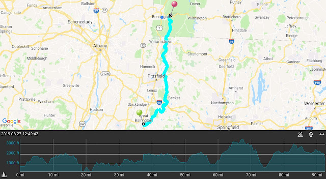
Total Distance: 1,612.8 Miles (2,595.6 km)
Section Distance: 92.4 Miles (148.7 km)
Section Elevation Up: 18,661 ft (5,688 m)
Section Elevation Down: 18,012 ft (5,490 m)


Thursday, August 22, 2019

Appalachian Trail: Kent, CT To Great Barrington, MA

🐻 x 6
UPDATED 11-21-2020

Three more days on the Appalachian Trail (AT) and three more days I considered quitting.  It's hard not thinking about it when you are hurting all over and still have miles to go.  I keep going but I wonder why sometimes.

Day 138 - My trail angel picked me up from the B&B and dropped me off at the Appalachian Trail trailhead where she picked me up a few days earlier.  I thanked her for her kindness and said my goodbyes.

The trail follows the Housatonic River and is relatively flat at the beginning.  Once you move away from the river the trail climbs the ridge.

My goal for the day was a campsite seventeen miles ahead.  Soon after I started I realized I wasn't going to make it that far.  I started later than normal, I was tired, and struggled most of the day.  I ended up stopping at the Pine Swamp Brook Shelter which had been my goal the day I had my accident.  I hiked 12.3 miles (19.8 km) for the day.

I was alone in the shelter that night.  A few thru-hikers came and went as I chilled in the shelter.  A couple of them I'd not seen since before the Smokies.  Crazy.  They all moved on to campsites farther down the trail.  Later that night it poured rain.  I stayed dry.

The Falls of Fall City, CT.
Day 139 - Since I'd hiked a short day the day before, today had to be a longer one.  I was aiming for just under twenty miles.  I doubted I would do it.

You pass near Fall City, CT and past the waterfall that gives the town its name.

The last part of the day was dry.  I filled up at a source after passing several dry streams.

I ended up at the Riga Shelter just over a mile short of my original destination.  The Riga shelter faces east and has an unobstructed view.  Few shelters have views so this makes Riga special.  I thought I may be alone at the shelter but Clemson, who I last saw before the Smokies, showed up and kept me company.

A beautiful sunrise to start the day.
Day 140 - I woke up to a thin red line on the horizon.  Skies were clear and I expected a gorgeous sunrise. It was a good start to another long day with no option to shorten it.  I was going into Great Barrington, MA.  I had to hike some eighteen miles that summited three peaks along the way.

The first peak was Bear Mountain (there are a lot of Bear Mountains).  The climb was relatively easy.  I talked to a southbounder at the top.  I mentioned thinking about quitting and she said there was so much beauty ahead of me.  I left feeling more positive.  The climb down was steep, rocky, and difficult.

At the bottom of Bear Mountain the trail follows a stream with waterfalls.  It was peaceful.  Along this stream I crossed into Massachusetts. Ten states down … four more to go.  They seem to be dropping like flies though not like the flies constantly buzzing around my head as I hike.

The second peak was Race Mountain.  You climb up a ridge with views along the way.  Parts of the trail were uncomfortably close to the edge of a cliff.  The climb down was steep, rocky, and difficult.

The third peak, Mount Everett, was steep, rocky, and difficult going up and coming down.  I found a rock on the way up to lay down for a nap.

A nice stream near the state border.
About two thirds of the way down from Mount Everett the rocks became fewer and the trail became pine needles covered dirt.  The trail comes out in a picnic area where a large number of water jugs and a cooler full of Gatorade waited for thru-hikers.  I drank a Gatorade while I ate some lunch and talked to a couple of thru-hikers.  One gave me the number for a shuttle driver in Great Barrington.

The next eight miles were relatively easy, dry, hot, and tiring.  I should have drank more water while I had the chance.  I don't always keep up with my water needs. I struggled a bit until I finally came out on the road to Great Barrington, MA.

I pulled out my phone to call a shuttle.  I had three bars but T-Mobile would not let me call.  I guess they didn't have an agreement with the local provider.  I sighed, put my pack back on, and started walking the two and a half miles into town.

When I got to the hotel my legs and feet were throbbing.  Going downhill on the rocks really banged up my toes.

Day 141 - I'm starting to think one zero day isn't enough and two zero days are too many.  Today I resupplied (I had to walk a mile to the grocery store), did laundry, and tried to rest my sore feet and legs.

A southbounder I talked to said the attitude of the northbounders was fifty-fifty good and bad.  I am squarely in the bad attitude group.  Now I just need to find a way to switch teams.

Pictures can be found in my 2019 Appalachian Trail Google Photos album.

Total Distance: 1,522.8 Miles (2,450.7 km)
Section Distance: 50.0 Miles (80.5 km)
Section Elevation Up: 9,871 ft (3,009 m)
Section Elevation Down: 9,560 ft (2,914 m)


Sunday, August 18, 2019

Appalachian Trail: Fort Montgomery, NY To Kent, CT

🐻 x 6
UPDATED 11-21-2020

There is a saying about the Camino de Santiago.  The first third breaks your body.  The second third - the Kansas-like messeta - breaks your spirit/mind.  The third part - beautiful Galicia - takes the pieces and puts you back together a better person.  The Appalachian Trail (AT) has put my body through the wringer and thoroughly broken my spirit.  I am ready for the rebuilding part please.

Day 131 - I left the town late because the zoo didn't open until 10:00am.  The hotel owner shuttled me and Shine (another thru-hiker I hadn't sent since Hampton, TN) to the South end of the zoo. Admission to the zoo is free for thru-hikers and the AT passes right through the zoo.  It was modest but nice enough.  In front of the bear enclosure the AT hits its lowest point around one hundred and twenty-four feet above sea level.   I got a stamp for my AT passport.

About five miles out of town you pass a deli/convenience store right by the trailhead.  I stopped and had a double decker burger, a pint of ice cream, and refilled my water bottle.

I was going to stop at the Graymoor Spiritual Life Center, a Franciscan Monastery where you can camp in their baseball field pavilion.  The problem was it was too early.  The next day was going to be a long one so if I kept going my next day would be easier. I hiked a few more hours cutting nearly five miles off the next day's hike.

I ended up putting my tent up in a clearing near a brook.  It was a nice spot but I had no one to share it with.

The maintainer for the RPH Shelter has a sense of humor.
Day 132 - I was the only person at the stealth site.  I left early and headed north.

The one interesting thing along this part of the trail was a side trail to a beach area along Canopus Lake.  You are allowed to camp there, there are showers, and they serve a pancake breakfast. Since it was the middle of the day I skipped the side trail and kept moving.

I ended the day at the RPH shelter which was very nice.  A thru-hiker named Montana showed up but she didn't stay.  We talked as she had a snack.  I spent the night alone.  This is the third time I was alone in a shelter.  It never feels right.

The largest oak tree on the AT.
Day 133 - My first stop of the day was a deli in Stormville, NY where I got a breakfast sandwich, a pint of ice cream, and topped off my water bottle.    Water was a bit scarce in this part of the AT.  Many sources were either dry or too small to get water out of.  Montana was here enjoying breakfast.

I ended the day at the Telephone Pioneers Shelter with a southbounder and a strange northbounder who thought he heard Sasquatch on the trail.

Near this shelter the little free libraries began appearing at the shelters.  Not sure how many thru-hikers would carry a book when an ebook or audiobook is a bit easier to carry.

Day 134 - I left the shelter and headed north.

My first rest stop was the Appalachian Trail RR Station.  The station consisted of a bench and trash cans.  I emptied my trash and ate a snack.  The sign above the bench said that one direction took you to New York City.  As I snacked I thought how easy it would be to wait for a train to show up, ride to New York City, switch to a commuter train to Newark Airport, and catch a non-stop flight to Omaha.  I got up and continued North.

These rails could have gotten me home in twenty-four hours.
I reached the Ten Mile River Shelter as it began to rain.  I sat out the rain with another thru-hiker and I ate lunch.   The rain stopped and I continued on.

I crossed into Connecticut, back to New York, and back into Connecticut on my way to the Schaghticoke Mountain Campsite.  I ran low of water as I passed one dry stream after another.  There was water at the campsite but it was a trickle and hard to get water out of but I managed to get enough out for the night.

The campsite was a rare one with a privy.  I had nicknamed some privies in the south Microprivies because your knees hit the door when it was closed.  In Connecticut they fixed that problem by not including doors … or walls.  The privy was simply a wooden box with a toilet seat in a clearing.  Yes … I used it.

The not so private privy.
I climbed in my tent and changed out of my wet clothes.  I have to admit that even I could smell the stench on my pants.

Day 135 - An eventful day.  I left the campsite and headed north looking for water.  After two more dry streams I arrived at a running brook where I drank up and filled my bottles.  I passed a group of northbound thru-hikers at a shelter.  I didn't know anyone but I recognized some names from the shelter journals.

I continued on past the turn off for Kent, CT and continued North.  It was going to be a twenty mile day and my body was dragging.  I reached the top of Caleb's Peak and laid down to nap on a rock.

Another thru-hiker showed up as I started to move on.  I got twenty to thirty feet down the trail when I tripped on something and hit the rocky trail hard.  I took stock of myself.  My glasses were bent but intact. Then I felt the blood dripping.  I took my sweat rag and wiped off a lot of blood.  I left my stuff on the trail and walked back to the thru-hiker and asked him to look at it since I couldn't see myself.  Turns out his trail name was Doc.  He helped me clean it up.

Other hiker showed up soon after and every one pulled out first aid supplies.  A pair of section hikers called one of their moms who lived in the area and asked her to come meet us at a trailhead.  We hiked just over a mile down a steep rocky slope.  I was still running on adrenaline and I surprised everyone by how fast I got down the mountain.

The section hiker's mom showed up and she was a saint.  She drove me to a hospital where I was cleaned up and glued back together.  It took four hours to get seen by a doctor.  She then took me to B&B in Kent, CT where I could heal up.  Before leaving she asked when she could pick me up to take me back to the trail.  What a nice woman.

There is a lot of art in Kent, CT
 including this thru-hiker sculpture.
Days 136 & 137 - The doctor told me no hiking for forty-eight hours so I took two zero days in Kent.  I have to say it is a comfortable place but everything seems expensive.  I am looking forward to getting back on the trail.

I was doing my laundry across from the post office and grocery store when I saw Choo Choo.  I went over and said Hi.  I told her about my fall - She'd had an injury early on similar to mine.  I asked her about the text I'd sent and she said that she was terrible at returning texts and that she'd thought about quitting in Delaware Water Gap.  She assured me that it wasn't anything I did.  It didn't ring true.  Her body language said that she just wanted this conversation to be over.  I wished her well and went back to the laundromat.

When Choo Choo and I had agreed to hike together back in Port Clinton I'd been very excited.  I thought I'd finally found someone to talk to at the end of the day and commiserate with.  I think my excitement may have come across as me being clingy.  Looking back I can see how this could have looked a bit stalker-ish and overbearing.  I wish she would have just come out and said what it was but I wasn't going to get an explanation and the closure that would have come with that.  *sigh*

Pictures can be found in my 2019 Appalachian Trail Google Photos album.

Total Distance: 1,473.8 Miles (2,371.8 km)
Section Distance: 70.0 Miles (112.6 km)
Section Elevation Up: 14,191 ft (4,325 m)
Section Elevation Down: 14,016 ft (4,272 m)


Sunday, August 11, 2019

Appalachian Trail: Greenwood Lake, NY To Fort Montgomery, NY

🐻 x 6
UPDATED 11-21-2020

The past few days have been … different.  I had a four day plan to get to Fort Montgomery, NY that was sort of a hiking vacation.  Every day was relatively short miles.  That plan went out the window on the first day.   I deviated from the plan and totally winged it.

On the horizon - the New York City skyline.
Day 128 - When I climbed down the hill into Greenwood Lake, NY I seriously considered not climbing back up.  I would skip the climb up and get a ride back to the Appalachian Trail (AT) skipping about two miles. When I woke up after my zero day I came to my purist senses and walked from the hotel to the Village Vista trailhead and climbed up the ridge.

I reached the goal for the day, the Wildcat Shelter.  It wasn't even 10:00am yet.  I checked out the water source and found it nearly dry.  The puddles that remained were looking at me … well the frogs in the puddles were watching me.

I went back to the shelter, grabbed my pack and kept going.  This was not my usual reaction.  I usually stick hard to my plan.  The next shelter was fourteen miles away so it would be a twenty mile day if I got there.

I used the AT Guide to estimate where I was. I estimated I was two miles from the shelter. I was totally off.  I reached a highway and realized I was still four miles from the shelter.

I reached a hiker's parking lot and ran into Ruckus.  He was considering quitting due to money issues.  For the past month or so he's been living off the kindness of other hikers and strangers.  He didn't like the idea of not being able to support himself.  I hope he finds a way to continue.

I left the parking lot and reentered the forest where I promptly saw a campsite.  The tent went up.  It began to rain an hour later. My tent has been getting used more often since I left Pennsylvania.

This was going to be a 5.6 mile (9.0 km) day but it turned into a 15.9 mile (25.6 km) day instead.   I have to admit I felt pretty good.

As an extra bonus, I saw my first flying wild turkey.  Its flight was quite graceful.

The highlight is an AT symbol.  Is the trail going into a cave?
No, it's going into the Lemon Squeezer.
Day 129 - The first thing I ran into this morning was the Lemon Squeezer.  The trail passes through narrow passages and up a wall.  To get up the wall I had to take off my pack and toss it and my poles up ahead of me.  This would have been a nightmare in the rain.

I passed a lake with a few tents set up.  It would have been great to have camped here the night before but I doubt I could have gotten here before the rain came down.

I passed the shelter I had been heading to the day before and passed a group of noisy camp kids and a leader with a bullhorn.  I was lucky not to get there the night before.

Squuuueeeezzzzeeee!
At this point I was heading for a shelter that was 0.6 miles off of the AT.  The shelter has no privy and the water is poor and a half mile from the shelter.  What it did have is a view of the Hudson River and the New York City skyline.  When I arrived at the turn off for the shelter I reconsidered.  I'd managed to see the skyline from another mountain earlier in the day.  I made the bet that I would see the lit up night skyline farther ahead so I passed the turn off and kept hiking.   I lost that bet.

I kept going with no real goal anymore.  I crossed two roads and climbed two ridges.  Finally I turned a corner near the top of Bear Mountain and saw a bench facing west toward the sunset.  Not far from the bench were several flat spots.  I set my tent up on a flat rock. Since this was not an official campsite this may have been my first stealth camping.  I was joined by a south bounder (SOBO) who put up her tent in the area and watched the sun set.

It wasn't going to rain so I left my rain fly off so I could see the stars.  Being close to New York City, and the east coast in general, the stars were a bit subdued but I still saw many through the mesh of my tent.

This day was going to be a 13.5 mile (21.7 km) day but it ended up being a 16.3 mile (26.2 km) day instead.  The last three miles were probably the best of the day.

It's hard to see but it says "< 800".
Sometime today I passed the one thousand four hundred miles.  I didn't see a marker but I did see a "< 800"  mile marker.  I guess we are now in count down mode.

Day 130 - I finished the climb up Bear Mountain.  At the top is a fire tower, a trash can, a port-a-potty, and vending machines.  I drank a Powerade and used the potty.

The rest of the day was down hill.  I passed an ice cream vending machine which I indulged in.  Yes, breakfast was ice cream and Powerade.

The sunrise over the Hudson River.
The trail goes through a zoo here and is free for thru-hikers.  Sadly it was not opened yet.  I will figure out how to get to the zoo before I leave.

I walked into town and arrived an hour before the Post Office opened.  I went to the surprisingly well stocked convenience store and bought some food to compliment what would be in my mailed resupply box.

I got my box and swapped out my shoes.  New Shoes baby!!!  I boxed up the cold weather gear in the box along with some food I didn't need and mailed it to myself farther ahead.  It wasn't quite ready for cold weather clothing yet but in a week or two that may change.

With my box in hand I hiked a half mile to a small hotel where I got a room.  I got some brunch, showered, got my laundry done.

I was going to take a zero on day 131 but instead I will leave late, go to the zoo which opens at 10:00am, and then hike a short day to the Graymoor Spiritual Life Center where they allow you to sleep at the monastery's ball field shelter, use their privy and shower, and have water.

After Graymoor I have several long challenging days ahead of me that will take me into Connecticut.

Pictures can be found in my 2019 Appalachian Trail Google Photos album.

Total Distance: 1,405.6 Miles (2,262.1 km)
Section Distance: 36.3 Miles (58.4 km)
Section Elevation Up: 7,599 ft (2,316 m)
Section Elevation Down: 8,001 ft (2,439 m)


Thursday, August 08, 2019

Appalachian Trail: Delaware Water Gap, PA To Greenwood Lake, NY

🐻 x 6
UPDATED 11-21-2020

I broke down this week.  A bunch of things came to a head all at once and I felt overwhelmed.  I had a mild anxiety attack.

I'm starting to wonder if my plan is too aggressive.  I hope I'm wrong.  I know of three people who have told me they are confident in finishing when they see me because they heard I had a plan.  If they are even with me or past me then they know they will get to Katahdin.  But … what happens when I begin to doubt my own plan.

A tranquil pond.  Do you see the Butterfly?
Day 122 - I left Delaware Water Gap, PA and, while crossing a bridge over the Delaware River, crossed into New Jersey.  The seventh state was behind me.  I'd not see or talked to Choo Choo after the first night in Delaware Water Gap.  I texted her telling her where I would be camping that night. 

The trail climbed back up the ridge.  There were rocks in New Jersey too but there was also dirt.  Logically I knew that the rocks would be just as bad as in Pennsylvania but it still felt less rocky.  I think it has to do with how the trails are maintained.

Somewhere I passed the one thousand three hundred mile marker but I didn't see it so no picture.

I ended the day at a campsite near Rattlesnake Spring.  This was my tenth tenting on the Appalachian Trail (AT).  Choo Choo never arrived and she didn't answer my text.  While I was setting up camp I wondered if I'd said or done something that had bothered her.  I'd heard many stories about women hikers on the AT being harassed and stalked. I sent one last text saying that if I'd said or done anything to offend her it was unintentional, I was sorry, and I wished her happy trails.  She didn't answer.  I was ghosted.  Alone again.

Another state behind me.
Day 123 - I woke up to a dry tent which made me happy.  I packed up and headed out.

My energy levels have been extremely low lately.  This day was no different.  I have been slowing down and taking more breaks during the day.  Even with the extra rest stops I'm often exhausted at the end of the day.  I think the AT is making me weary.

I came to a road crossing and realized there was a restaurant not far away.  I stopped at the Mountain House Tavern and Restaurant and relaxed in the air conditioned space, drank some lemonade, and ate my first good Mountain House meal.

In the first half of the AT I would have known about the restaurant because I would have studied the guide book.  Since Harper's Ferry I've been paying less and less attention to the guide book.  The results are I am surprised by restaurants and other points of interest along the trail.

I drug my way away from the cool air and finished the short climb to the Gren Anderson Shelter.

Day 124 - The surprise of the day was how close the trail went to
High Point Tower.
High Point State Park headquarters.  Turns out if you are a thru-hiker and sign their log book they give you a soda.  I ran into a few thru-hikers taking a break here including Salamander.  I also took a short nap before I moved on.

The trail passes a place where you can see the tower on the highest point in New Jersey.

I reached a road crossing that would take me to Unionville, NY.  I started to walk the three quarters of a mile to town when a car pulled up.  In the passenger seat was Salamander.  She had recognized me and asked the driver to pull over. I squeezed in between the two car seats and they took me to town.  Salamander said she was going to a drive in movie theater where the owners let you camp.  She asked if I wanted to go too.  I decided not to go.  I was concerned I would have difficulty getting out of the town and back on trail.  Looking back now, I should have gone with Salamander.  Most of my isolation along the trail was self-induced.

Unionville offered free camping in the town park.  I ate a good meal at an Italian restaurant and had a rather restless sleep.

Day 125 - I packed up and bought a breakfast sandwich at the general store before walking back to the trail and heading North.

The trail follows roads, skirting a nature preserve where I saw a flock of egrets, before heading back up the ridge.  Part way up the ridge you pass a vacant house where the guide suggests getting water from a spigot.

Farther ahead the trail was a boardwalk through a swampy area.  The boardwalk stretches nearly a mile and incorporates a suspension bridge over a creek.  The only bad thing about this is there was no shade on his part of the trail.  I did manage to find a rare bench in a spot of shade and took a short nap.  During this leg I'd played leap frog with a German girl named Wind and the two couples she was hiking with.  They passed me while I was napping on the bench.  They kept saying they were hiking faster than I was but, as I passed them farther ahead I pointed out that if I was so slow, why was I passing them now.  We all got a smile out of that.

The flattest part of the Appalachian Trail.
I found another surprise when I ran across Heaven Hill Farm.  I stopped here and bought ice cream and watermelon.  I talked with a local woman with her mother.  Her mother seemed to have Alzheimer's.  I patiently answered the same questions about the AT several times.  

I ended the day at the Wawayanda Shelter.  As I was arriving Wind passed me and asked me if I was going to the Drive In theater.  Once again I said no.  

I was alone at the shelter.  I looked at the guide book and realized the next resupply town didn't look very good.  I became frustrated.  The difficulty of the trail, the lack of substantial social interaction, and the difficulty of making my plan work all reached a peak.  I was still stewing about Choo Choo and the lack of an explanation.

On top of that a friend I'd met on the Camino who lived in New Jersey suggested meeting me.  I gave her my schedule and asked her to contact me when she returned from a trip to Peru she was taking so we could coordinate and meet up.  She said she would but … She never got back to me.  No explanations.  No I'm sorrys.

To add to it all, a few weeks back Curry had texted me and said she wanted to jump ahead and join me for the rest of the AT.  We'd agreed that her boyfriend would drop her at Delaware Water Gap.  This made me very happy and I was really looking forward to reuniting with one of my original trail family members.  About a week before I got to Delaware Water Gap she texted me that, after talking to her boyfriend, she'd decided she was going to quit.  That was a blow but at least she apologized and explained why she wasn't joining me.

All these things, along with my self-sabotaging, came to a head in the Wawayanda shelter.  I had a mini breakdown.  I called the Wife so she could talk me down.  The AT is not getting easier for me.  Thoughts of quitting began creeping into my thoughts.

Even another state behind me.
Days 126 & 127 - I hiked eight miles, across the boarder between New Jersey and New York, to a side trail that took me sharply down a ridge into the town of Greenwood Lake, NY.

The first hotel was full.  The second had a room.  The town has little resupply resources available but they have restaurants and there are some convenience stores and a drug store to scrape together supplies for the next few days on the trail.

I think I'm the only hiker in town.  It feels very lonely.  I looked at the next few days and I added stops to shorten some days.  I'm giving myself a sort of hiking vacation.  Today I will hike only five or six miles to the next shelter.  The changes I made will eliminate a few twenty mile days but add a few days to my AT hike.  Shortening the next few days will not help me feel less alone as the thru-hikers I know will very likely pass me up and once again I will be behind the bubble.  That is the hardest part of this endeavor.

Pictures can be found in my 2019 Appalachian Trail Google Photos album.

Total Distance: 1,371.7 Miles (2,207.5 km)
Section Distance: 79.8 Miles (128.4 km)
Section Elevation Up: 11,860 ft (3,615 m)
Section Elevation Down: 11,222 ft (3,421 m)


Tuesday, August 06, 2019

Appalachian Trail: Port Clinton, PA To Delaware Water Gap, PA

🐻 x 6
UPDATED 11-21-2020

"Pennsylvania is trying to kill us."
  That is what one thru-hiker wrote in a shelter log.  That sentiment is shared by a lot of hikers, myself included.  The rocks, heat, humidity, rain, lack of water sources, and insects all conspire to make Rocksylvania the place where many thru-hikers reconsider why they were hiking the Appalachian Trail (AT).

Rock, rocks, and more rocks.
Day 116 - The day before I left I ran into Choo Choo, another thru-hiker I'd met a few times along trail.  She'd been hiking with Red Bush and she was a bit down because he had been injured and had gone home.  We decided to coordinate our stops for the next few days.

This day gave us Pulpit Rock and the Pinnacle.  Near Pulpit Rock was an amateur astronomy park.  I spoke with a few of the members doing maintenance.  They shared cold bottles of water.  One of them who does trail maintenance warned me about the next section I would be crossing tomorrow.

The stop of the day was Eckville Shelter.  This run down shelter has a caretaker and sports a solar shower.  By solar I mean cold.  I chose not to partake.

A pair of buzzards sitting on Balance Rock.
Day 117 - This day was a long day as were all days in Pennsylvania.  As promised the trail was rocky with interspersed boulder hops.

I prefer the boulder hops.  The little rocks on the trail are all evil ankle turners and trippers.  Having said this, the boulder hops also have the most risk of real damage if you fall. They also slow you down as you consider every step carefully. This day had the Knife Edge, Bear Rocks, and the crazy decent from Bake Oven Knob.

I stopped for water at a closed restaurant which had a spigot.  The water was disgusting and I filled two bottles before I noticed the smell and taste.  Fortunately at the base of Bake Oven Knob some trail angel had left bottles of water.  I dumped the foul tasting water and refilled my bottles and dropped a chlorine tablet to kill any possible contamination in the bottles.

The day ended with a stay in Bake Oven Knob shelter (I keep wanting to say easy bake oven).

An AT marker.
Day 118 - After a long and grueling day this was was going to be shorter.  I figured it wouldn't be to bad then I began climbing out of Lehigh Gap.

The climb was a thousand feet over just under a mile.  The top third or so was a rather technical rock hop.  I got to this point after already hiking eight miles and it was during the heat of the day.

I was passed by Ruckus, Salamander, Lunchbox, and Jaywalk as I huffed, puffed, and wheezed my way up.  I caught up with Salamander and Ruckus as they sat on a long in the shade.  I joined them and ate a snack.

I reached Little Gap road and waited for Choo Choo before calling the Filbert B&B. The house was pre-civil war and beautifully decorated.

We arrived rather late for me so I had time for a shower and a quick meal before going to bed.

The red and black bird wonders if this is really a trail.
Day 119 - Despite wanting to get back in trail by 7:00am we didn't get going until 8:00am.  Neither Choo Choo nor I were very enthusiastic about hiking.  The terrific breakfast didn't give me the energy that I expected.

I was dragging early on.  At the one third point of the day I came across the perfect flat Rock and took a thirty minute nap.  At the half way point I reached a Gap where I laid down on a barrier for fifteen minutes.  At the Leroy A. Smith shelter I took another thirty minute nap.  Rocksylvania was wearing me down and I found each day to be a little bit harder than the day before.

I ended the day at the Gateway motel outside of Wind Gap, PA.  The place was a dump and overpriced but the AC worked, the shower was hot, and the toilet flushed.  It was also within view of the AT.  It was definitely not the Filbert B&B.

Less than nine hundred miles and going down each day.
Days 120 & 121 - The last day in Pennsylvania was another day of rocks.  The state threw everything at me. The last boulder hopping at Wolf Rock.  Miles of rocky trails.  And as I neared Delaware Water Gap it poured rain.

As I was descending the last hill into town I slipped on a wet rock and came down hard on my left upper arm.  I'm sporting a nasty bruise but no other damage.  I was lucky.  The rock I hit looked like a dull knife's edge.

I walked to a hostel in the pouring rain but it was full so I walked to a hotel and got a room.  Choo choo ended up in the hotel too.  I did laundry and had a restless sleep.

On my second day in Delaware Water Gap, and the last day of Pennsylvania, I took a Lyft to Walmart to resupply.

The next five days in and out of New Jersey are going to be tough.  The rocks will diminish with time and distance but I have some long days planned.

Pictures can be found in my 2019 Appalachian Trail Google Photos album.

Total Distance: 1,295.4 Miles (2,084.7 km)
Section Distance: 81.8 Miles (131.6 km)
Section Elevation Up: 10,453 ft (3,186 m)
Section Elevation Down: 10,920 ft (3,328 m)


Note: This post is late because the hotel WiFi was down and my cell reception was spotty at best.