The other day the wife said something that got me thinking. She said she hadn't realized I liked the outdoors so much and that, when I was talking about my bushwhacking and river wading experience, that I sounded (and smiled) like a 10 year old. I mentioned at the time that the first nine years of my life was in the woods. She then said "Oh, you're behaving like a nine year old." I think she's on to something. The first nine years of my life was spent on the shores of the Lake of the Ozarks. My parents were busy taking care of the resort they owned and my brother, five years older then me, was too inconvenienced to take me with him and his friends so I used to wander the resort, the lake shore, and the surrounding woods alone at a relatively young age. I used to love walking through the trees - a rich source for the imagination of a young boy. I guess this is where my love of the woods, and nature in general, was locked in. I used to think I was miles away from home when in fact I never wondered more then a half a mile. Everything seems bigger when you're small.
Just before I turned nine, we moved away from the lake - left the country completely - and my life drifted towards the urban. Looking back, over the next 30 some years, I made several aborted attempts to get back to the nature of my childhood. I will post about some of those attempts someday. For now, my hiking is my latest attempt and as my hikes lengthen and I do more and more adventurous things (adventurous for me anyway), some of that nine year old in me surfaces. What a wonderful thing.
Tuesday, May 29, 2007
Sunday, May 27, 2007
Thank You ... We Remember
Thank you to all those who put their lives on the line for us everyday and those who made the ultimate sacrifice for Freedom.


Santa Barbara I Madonnari 2007

Saturday, May 26, 2007
The Day After ... It's Alive!!
Well, today we were supposed to go to Soledad and Carmel Missions. After my hike yesterday and the submersion of my camera, we decided to postpone the Mission trip and just spend a calm day at home relaxing. I am feeling muscles that I didn't know I had. I have a sore butt which is either a result of climbing the butte or sliding down the butte on my butt - not sure which. Overall, though, my sore muscles are not as bad as I expected. Even the scratches aren't bothering me as much as I thought. Good News. I usually pop ibuprofen when I get home from hiking and that usually mitigates the aches and pains. Last night I also pop some Excedrin PM to help me sleep - worked like a champ.
We spent the after noon catching up on some TV. We watched an adventure special about rafting in Bhutan and two episodes of Survivorman. Survivorman is pretty cool. A survivor trainer has to survive on his own for 7 days in different environments. He does his own filming so he is totally alone with no food or water. Interesting to watch now that I am hiking.
There is a little more good news - my camera is starting to come back to life. This morning it powered up but the screen was blank. This afternoon the screen came on but there was a little intermittent static. I expect it is still drying out. Hopefully by tomorrow all the water bugs will be out of it. Keep your fingers crossed.
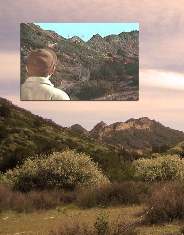
Hiking Ventura County #18: M*A*S*H Film Site - Malibu Creek State Park
The first half was easy. The trail starts as a dirt road. Along this road I completed my first multi-cache ("Watch out for the fire-breathing troll!"). A multi-cache has multiple containers - one container has the coordinates for the next which has the coordinates for the next, etc. In the last container I swapped the Balloon #2 geocoin I had with a Green 12 Days of Caching geocoin.
To my delight, the dirt road narrowed to a single hiking path shaded by trees. The hike follows Malibu Creek and passes by Century Lake. After the lake it rounds a bend where the path is shaded by oaks and other trees. Along the trail I saw my first large animal - Bambi and her mother. I didn't manage to get a picture unfortunately. You could also hear the hammering of a Woodpecker.

I left the MASH site and took the Lost Cabin Trail. As I walked the trail I heard a helicopter in the distance - could have sworn I heard Radar yelling "Incoming Wounded!" At the end of this trail there was another cache ("Judy's Cabin"). The hider had built a Lincoln Log cabin to cover the cache - very clever.
As I was walking this trail I was keeping an eye on the butte along the trail. I was hoping to locate a wash or a game trail that would lead me up the side of the butte where I thought there was another cache. . On the way back I followed what looked like a trail and I eventually found what, on a good day, may be called a game trail. I headed up and started bushwhacking my way up the butte. The going was slow and calling this a trail would not be completely accurate. I had to stop every now and then to allow my heart to slow back to normal. By the time I reached the top I was pooped. I checked my GPS hoping to see that I was near one of the caches ("Bat Cave", "Malibu Macro", and "Malibu Micro"). Unfortunately, I was on the wrong butte. Darn. I had hoped there would be some way to get to the other buttes but there wasn't a butte bridge in sight.
I located a game trail going down the other side of the butte and I headed down. I learned a couple things about game trails on this hike. The first is game rarely goes where you want to go. In this case, the trails led away from the caches. The second is that game is generally short. While the trail was fairly obvious, brush grew over the game trail baring my way. Most game, being short like coyotes, would have no problem going under the tangled branches. Since I am not short, I had to wrestle with the brush all the way down. I followed what I thought was a trail heading down to the creek. As I made my way slowly down the butte, I was convinced that I would die the death of a thousand cuts. The bush became more tangle and the trees more sharp. There were parts where I slid down the butte on my butt. I made it to the creek - actually a tributary that feeds run off into Malibu Creek. I followed the almost dry tributary until I reached the main creek.

I continued up the river and, after climbing a boulder, the dam came into view. It looked cool with algae and sea plants growing where the water ran over the dam. I pulled out the camera and slid the lens cover over and ... nothing. The camera was dead. CRAP! Water got into the camera. I've been meaning to buy a new camera just not yet. Sigh.
I climbed up the rocks and onto the dam. There was a geocache nearby ("Malibu Redwoods"). After the cache I was planning to cross the dam but that turned out not to be an option. Once there had been a bridge crossing the dam but not anymore. I followed the Forest Trail along the century lake back towards the M*A*S*H site. There were ducks and other water fowl in the lake. I made it back to the main trail and headed for my last cache of this hike ("Malibu Creek A.K.A. Heffers' Ghost"). After finding the cache, I headed for Rock Pool where several movie scenes were filmed including Planet Of The Apes and Butch Cassidy and the Sundance Kid. Of course, along the way, there were several great picture taking opportunities that were missed forever.
I really liked this hike even though my butte climbs and river wading experiences were grueling. It sucks about the camera. Amazingly, the tick count on this hike was only one. After all the bushwhacking I did I expected to be covered in hundreds. I sprayed myself with 40% DEET which was stronger then the other stuff I was using (25%) - maybe that helped. My total hike was 7.04 miles and my climb was about 600 ft. Pictures can be found here.
Wednesday, May 23, 2007
Past Vacations #18: Yosemite, Manzanar, And Death Valley
This was a strange but satisfying vacation. We decided to go to Yosemite. The decision was a little spur of the moment - at least for us - we only planned about a month ahead or so instead of the year or two ahead as we usually do. The plan was to drive to Yosemite and spend three days enjoying the beauty of the park.
We left on a Wednesday. The drive to the park was uneventful. We checked into our hotel near the southern gate to the park. We then drove into the park to get information that we would need to plan our visit. As we drove in I saw a sign that said "Ride The Logger!" I read the sign out loud and the wife almost squirted Diet Mountain Dew out her nose! HA! Unfortunately we never rode the logger (a train) so I have no pictures, magnet, or a T-Shirt.
Our first day was a preview of the next - HOT! It was easily in the 90s. We spent part of the evening in the hotel pool cooling off.
HOT
 The next day we entered the park and made our way towards the valley. Before entering the valley we stopped at Glacier Point which offers a panoramic view of Yosemite Valley. From here you can see all of the valley, El Capitan, and Half Dome. The views are breathtaking. We tore ourselves from the heavenly vistas and drove into the valley. Traffic, as usual, was pretty crappy. We reached the end of the valley and stopped at the Ahwahnee Lodge Dining Room for lunch - one of the wife's goals. Pictures of Yosemite are here.
After lunch we were going to do a short hike but after reaching the trailhead, the 100°F+ stopped us in our tracks. This irritated the heck out of me and the ugly side of my temper came out. We stopped at Yosemite Falls and I sulked and really didn't enjoy the beautiful falls. Me and heat do not go together and I was really disappointed about not being able to hike. On the way back to the hotel we decided that staying in Yosemite was not going to work. The forecast was for temps in the 100s and no relief.
We weighed our options and decided to look into going to Manzanar. We had talked about visiting this WWII Japanese Internment Camp for awhile. We had been interested in going since they opened the new visitor's center in 2004. At the hotel we asked the counter person about Manzanar. The counter person didn't have a clue about Manzanar (as do most Americans unfortunately). She managed to pull up some information on the Internets and gave us a print out.
The next day we checked out of the hotel and drove back into Yosemite. To get to Manzanar we would drive through the park and leave by the eastern exit. The drive through the park is really awesome. After reaching the eastern exit we turned south. As we drove south it got hotter and hotter. The Honda's AC worked overtime. We stopped in Bishop for a quick lunch. It was 100°F outside and I saw this poor Goth girl in full BLACK goth regalia. She must have been roasting in that getup.
HOTTER
 We made it to Manzanar mid-afternoon. It was hot (did I say it was hot?), dry, and the wind was whipping. Manzanar is located in the middle of hot dry Owens Valley. The only structure standing is the old gymnasium which had been converted into a visitors center. We walked through the exhibits learning about how the Japanese - even the US born - were rounded up and moved to intern camps similar to Manzanar - 10 camps in total. It is sad how little Americans know of this dark stain on our history. Along with the exhibits, there is a movie that tells the history of the camp. The wife and I were the only people in the theater. When the film reached the attack on Pearl Harbor, the electricity went out and alarms sounded. We both looked around wondering if this was part of the show. Turns out the wind had knocked out the electricity - a common occurrence in the area. The power was soon restored and we finished the movie.
One of the exhibits was a list of names of those who were in the camp. The wife once taught a student whose Grandmother was interned at Manzanar. She doesn't talk about that period of her life. Another exhibit told of a son of one of the interns who joined the army, fought bravely, and died in Europe. His medals were granted after his death and had to be delivered to his mother at Manzanar because she was not allowed out of the camp to receive them. Sad.
We then got back in the car and took a driving tour of the camp. The buildings are gone except for some foundations. One interesting remains are of fountains and rock lined ponds created by the internees - bringing some beauty and civilization to their imprisonment. The most memorable part of the park is the cemetery marked by an obelisk. Many of the graves are small - Children presumably. There is evidence of visitors as most graves are decorated. The cemetery fence is decorated with origami cranes left by visitors. Along with the gymnasium/visitor's center and the cemetery there are a couple of guard shacks and a restored guard tower. Some Manzanar pictures are here.
We spent the night in the town of Lone Pine. Many western movies were filmed near here. This town is also the gateway to Mount Whitney, the tallest mountain in the contiguous 48 states. I know a guy who will be climbing it this August.
HOTTEST
 Since we had one more day left on our vacation, and it was hot everywhere we had been, we decided to take the temperature to the extreme. We left Lone Pine and drove into Death Valley. The temperature in Death Valley was 117°F (It had been 125°F earlier that week). We visited Scotty's Castle where we toured the impressive home. It's pretty cool - even in the desert heat. When we reached the car, a bird had dropped a load on the top of the car -It was the size of my thumb!! We laughed that somewhere that bird was screaming in agony. Ha!After the castle we drove to the Ubehebe Crater. It was so hot that we only jumped out of the car, took some quick pictures of the volcanic crater, and jumped back in. It was pretty neat though. We got back to the main road and headed for Badwater Basin, the lowest point in North America. I decided to walk out on the salt flats. It was like walking through a furnace. It had rained recently (yes it rains in Death Valley) and the salt stuck to the bottom of my shoes. My feet got heavier as I walked. The salt formed little stalagmites standing a quarter to a half inch off the ground. The scenery was a little surrealistic. I had two bottles of water with me and they were getting hot. I turned around and started back to the car. I had to put my camera in my pocket because the metal case was getting to warm to hold in my hand. The wife was in the car with the AC running. I got in and we made our way out of the valley. We were going to stay in the valley but all the hotels were full so we set our sights on Ridgecrest. Some Death Valley pictures are here.
We drove out the west park exit and turned south. The road drives through hills and dry lake beds. We stopped in the town of Trona. Half of the buildings in Trona were boarded up. It was a little weird. I should have taken pictures but I didn't. We stopped at the local gas station but the electricity was out and we couldn't fill up. We got back in the car and continued on our way to Ridgecrest.
Ridgecrest, at the time, was a very important place for me. They were talking about moving my job to the China Lake Naval Weapons Center. China Lake refers to the dry lake bed where the center is located. The wife had joked that she would move there if we had a pool. After visiting she said that a pool was not enough. I agree. Fortunately It turned out that my job wasn't going anywhere and the scary prospect of moving to Ridgecrest no longer haunts us.
Our vacations are usually planned ahead. This one was planned on the fly which resulted in many unexpected discoveries.This turned out to be a great vacation full of American history and Nature's extremes of beauty and desolation. There is something to say for spontaneity.
We left on a Wednesday. The drive to the park was uneventful. We checked into our hotel near the southern gate to the park. We then drove into the park to get information that we would need to plan our visit. As we drove in I saw a sign that said "Ride The Logger!" I read the sign out loud and the wife almost squirted Diet Mountain Dew out her nose! HA! Unfortunately we never rode the logger (a train) so I have no pictures, magnet, or a T-Shirt.
Our first day was a preview of the next - HOT! It was easily in the 90s. We spent part of the evening in the hotel pool cooling off.
HOT

After lunch we were going to do a short hike but after reaching the trailhead, the 100°F+ stopped us in our tracks. This irritated the heck out of me and the ugly side of my temper came out. We stopped at Yosemite Falls and I sulked and really didn't enjoy the beautiful falls. Me and heat do not go together and I was really disappointed about not being able to hike. On the way back to the hotel we decided that staying in Yosemite was not going to work. The forecast was for temps in the 100s and no relief.
We weighed our options and decided to look into going to Manzanar. We had talked about visiting this WWII Japanese Internment Camp for awhile. We had been interested in going since they opened the new visitor's center in 2004. At the hotel we asked the counter person about Manzanar. The counter person didn't have a clue about Manzanar (as do most Americans unfortunately). She managed to pull up some information on the Internets and gave us a print out.
The next day we checked out of the hotel and drove back into Yosemite. To get to Manzanar we would drive through the park and leave by the eastern exit. The drive through the park is really awesome. After reaching the eastern exit we turned south. As we drove south it got hotter and hotter. The Honda's AC worked overtime. We stopped in Bishop for a quick lunch. It was 100°F outside and I saw this poor Goth girl in full BLACK goth regalia. She must have been roasting in that getup.
HOTTER

One of the exhibits was a list of names of those who were in the camp. The wife once taught a student whose Grandmother was interned at Manzanar. She doesn't talk about that period of her life. Another exhibit told of a son of one of the interns who joined the army, fought bravely, and died in Europe. His medals were granted after his death and had to be delivered to his mother at Manzanar because she was not allowed out of the camp to receive them. Sad.
We then got back in the car and took a driving tour of the camp. The buildings are gone except for some foundations. One interesting remains are of fountains and rock lined ponds created by the internees - bringing some beauty and civilization to their imprisonment. The most memorable part of the park is the cemetery marked by an obelisk. Many of the graves are small - Children presumably. There is evidence of visitors as most graves are decorated. The cemetery fence is decorated with origami cranes left by visitors. Along with the gymnasium/visitor's center and the cemetery there are a couple of guard shacks and a restored guard tower. Some Manzanar pictures are here.
We spent the night in the town of Lone Pine. Many western movies were filmed near here. This town is also the gateway to Mount Whitney, the tallest mountain in the contiguous 48 states. I know a guy who will be climbing it this August.
HOTTEST

We drove out the west park exit and turned south. The road drives through hills and dry lake beds. We stopped in the town of Trona. Half of the buildings in Trona were boarded up. It was a little weird. I should have taken pictures but I didn't. We stopped at the local gas station but the electricity was out and we couldn't fill up. We got back in the car and continued on our way to Ridgecrest.
Ridgecrest, at the time, was a very important place for me. They were talking about moving my job to the China Lake Naval Weapons Center. China Lake refers to the dry lake bed where the center is located. The wife had joked that she would move there if we had a pool. After visiting she said that a pool was not enough. I agree. Fortunately It turned out that my job wasn't going anywhere and the scary prospect of moving to Ridgecrest no longer haunts us.
Our vacations are usually planned ahead. This one was planned on the fly which resulted in many unexpected discoveries.This turned out to be a great vacation full of American history and Nature's extremes of beauty and desolation. There is something to say for spontaneity.
Monday, May 21, 2007
Hiking Ventura County #17: Santa Rosa Trail
This hike could be split into three segments. The first third of the Santa Rosa Trail climbs the Mountclef Ridge. On the trail up I did a couple Geocaches ("Indian Winter" and "Boulder Gate"). There were four more nearby but I thought they were on another trail so I proceeded in making my way up the ridge.

At the top of the ridge I checked the GPS and realized that the four caches that I thought were on another trail were actually on the ridge line. The trail turned right but the caches were to the left so to the left I went. The caches ("Rabbit Racers", "Wildwood Minarets Travel bug Resort", "One To Go", and "Voce Dorata") took me further out on the ridge. The further out on the ridge I went, the narrower the ridge got until the trail became hard to follow and I had to start scrambling. Fortunately I had modified my walking stick last week, adding a lanyard to the end. I had drilled a hole in the end of the walking staff and attached a cord from a digital compass I had. This cord allowed me to hang the staff from my wrist freeing up my hand while climbing. Worked great.
The last cache was at the end of the ridge. In the cache I found the Jerry Garcia Lives Travel Bug. I exchanged that for the POW-MIA geocoin that I had. The views from the cache site were awesome even if the fog obscured the view of the lowlands on either side of the ridge. I enjoyed the views of Wildwood Park while I rested.
The way back to the main trail was more difficult. It was harder to see where the trail went and I had to backtrack a few times. On one attempt to scramble up some rocks, I slipped, smacking the scab from the Alpine Slide injury, and bloodying my weenus (Hey Hey! keep it clean. The weenus is the loose skin at the end of your elbow). I had a new first aid kit with me on this hike but my injury wasn't worth a bandage or anything.
The second third of the trail headed toward the Cal Lutheran University campus. After my detour to the ridge, I returned to the trail and came to another decision point - east trail or south trail. I chose south - the wrong decision because there were four caches on the east trail. The south trail eventually met back up with the east trail and I decided to backtrack on the east trail to do the caches. I ended up dropping the Jerry Garcia Lives TB in another cache ("Planet Wildwood") trading it for the T.V. Balloon geocoin. I also did "Santa Rosa Trail Spur", "Full Moon Buck", and "Things Are Not What They Seem". At this last cache I was attacked by ticks, finding three on me while I was examining the cache.
The last third of the hike goes through residential areas. This was the least satisfying part of the hike. I left the Santa Rosa Trail when it reached the Cal Lutheran Campus. From there I took the residential streets back to the trailhead. The sun started to peek out of the clouds just in time to shine on the picturesque asphalt.
This hike had a few firsts - I had my newly modified walking stick lanyard (a success), I had a 2 liter camelbak instead of bottles (felt good but it's hard to tell how much water you have left), I carried a first aid kit (didn't use it but it felt good knowing I had it if I needed it) and I had a mesh drawstring bag to carry out trash I found on the ridge (I still need to figure out how to attach it so it doesn't bounce around while I walk - mixed success).
The first third made the hike worth it. The whole hike was 7.26 miles and the elevation gain was about 480 ft. Pictures, as usual, are here.
Sunday, May 20, 2007
A Saturday Of Science And Spirituality

At first this was disappointing but I realized that I had seen most of the exhibits already. I have been interested in space exploration since I was a little kid. I had seen all the pictures and I followed many of the missions. I monitor the Space.com RSS feed. The exhibits were not geared towards the knowledgeable person - they were geared to the uninformed but interested or the hardcore Space Geek (I did see a guy in a full Star Trek: Enterprise uniform). I am somewhere in the middle and the result is that my visit to JPL was pretty dull.
I went to the designated rendezvous point and waited. The wife and the "J" showed up about 40 minutes late. They had gone to one of the exhibits and had stood in line for an hour. We got some dinner (Burgers and Hot Dogs) and I bought a couple of T-Shirts for my collection. They did not have magnets - Bummer. We did stop to ask the Scientist a question. The wife asked about Black Holes and the "J" asked what he would be if he weren't a Scientist (He would have been an Historian or a Linguist). I abstained from asking a question. A few pictures here.

Well, this was a strange day. Then again, we thrive on strange stuff. It didn't quite live up to my expectations but it wasn't terrible either. We can now say that we have been to JPL and to the Rose Bowl.
Tuesday, May 15, 2007
Past Vacations #17: New York City 2005
DISCLAIMER :
My recollection of this vacation, specifically what happened, when, on Wednesday, Thursday, and Friday, is vague at best. I am sure the Godson will find errors in this telling of the New York vacation story. Any corrections or additions can be made in the comments.

We flew out the week before Easter. We took a cab from JFK to the Godson's apartment in Spanish Harlem. The cabbie had little, if any, idea how to get there. We had to help him navigate. We were a little worried but we eventually made it. The Godson's apartment is perfect for the single guy. The place was new - he was the first occupant in that particular apartment.
On Sunday we all took the subway and went to the Cathedral for Mass. Later that day we went to the Tenement Museum. We bought a ticket to the museum tour and then went to a nearby coffee house where we bought snacks and something to drink while we waited for our tour. The tour takes you through a restored tenement building - an example of how Irish immigrants lived in the late 1800s.
On Monday the Godson had to go back to work so the wife and I, armed with the Godson's pocket subway map and directions, headed out on our own. We took the subway downtown. We returned to the Cathedral so the wife could peruse the gift shop. We visited the wife's favoritest place in the whole wide world - Tiffanys. Tiffanys was followed by Rockefeller Center (The ice rink is much smaller than I imagined), lunch, and a tour of NBC Studios.
After NBC we headed for the Empire State Building where we stood is a hellacious line. The view from the observation deck was pretty cool. The weather reduced the view a bit but it was still the highest I've ever been in a building. During my first trip I had an opportunity to go up in the World Trade Center but decided not to do it because of the lines. I regret that decision as I will never have the chance again.

On Tuesday the wife and I headed to Battery Park to catch a ferry out to the Statue of Liberty. The weather was great that day and we had some great views of Lady Liberty. I wasn't sure what to expect and it turned out to be pretty cool.
After some lunch on Liberty Island we caught another ferry to Ellis Island where we toured. Thinking of how many people were processed there makes the head spin. An interesting place for those interested in history.
We returned to the Battery Park and made our way to Wall Street and ground zero. I had my picture taken by the bull and we both somberly looked at the remains of the World Trade Center. We than made our way back to the Godson's apartment.
On Wednesday, the Godson only had to work half a day. The wife and I slept in late and eventually made our way to the Bronx to visit the Godson's school. The school day ended at noon with the kids doing the Stations Of The Cross (It was just before Easter). The Godson then gave us a quick tour of the school before we got back on the Subway. On the ride a boy kept popping in our car and trying to shoot us with a potato gun. If he had done it one more time I would have grabbed the gun but he got away.
OK, Here is where the memory becomes murky. It's weird that I remember older vacations clearer than this one. Maybe it's because we were doing so much cool stuff and it all just blurred together. I remember what we did but not when we did it.
I think we went to a couple movies near times square on Wednesday. First we went to see Bride & Prejudice, a Bollywood movie that didn't do too much for me. I'm not really into musicals. The wife and Godson liked it though. The second movie was Gunner Palace. This was a documentary about soldiers in Iraq. I picked this one. I'm a sucker for a good documentary. This wasn't one. At least, this wasn't the time for one. I think a more upbeat movie would have set us in a better mood. My bad.
After the movie we went to an Irish Pub and played trivia. We kept yelling out the answers which was probably why we lost but we didn't suck either. We had some good food and drink and trivia-ed away the night before heading back to the apartment to crash.

We eventually decided to have a Steak dinner (Not sure what day ... blurry .... soooo blurry). The Godson checked around on-line and found a place that seemed promising. We headed out and when we got there we were really confused. The place looked more like a diner then a steak house. We asked the girl at the counter if they served steak. This turned out to be a challenge since she hardly spoke English. My guess is that she was Russian. She finally said that they did serve steak and we sat down and had some grub. It turned out to be OK but it was not what we expected.
I'm not sure about Friday. I think we rode the Staten Island Ferry. That's all we did - ride the ferry. Once we reached Staten Island, we got off then got back on and rode it back. Now we can say we've been on a New York Ferry.
The vacation was great, in spite off my chronologically challenge memory. The Godson was a gracious host and his is always welcome to visit our place (which he has done several times). Pictures are here.
Sunday, May 13, 2007
Sliding Through The Bottle Forest
It is strange how things work out sometimes. You set your sights on one destination and on the way are blown off course and discover something unexpected and wondrous. Saturday's roadtrip was such a journey.
 The wife and I, joined by the "J", headed to Big Bear Lake to ride the alpine slide. The drive was about three hours. On the way we had to detour when the 210 Freeway unexpectedly came to an end. Not knowing where we were going, we followed the traffic until we made it back on course. We made our way up the mountains to Big Bear, peaking at around 7,112 feet. The road is a twisty - turny - winding - twirling road and the wife was not appreciating the beauty of it all. That road was trying its best to make her hurl. I slowed down the best I could to diminish her stomach churning. We finally made it to the lake and made our way to the Alpine Slide at Magic Mountain. Before starting our runs down the slide, we paused to let the wife's stomach to calm by stopping at the snack bar and dining on Hot Dogs and Chicken Strips.
I was hoping to take some pictures on my way down the slide and from the ski lift on the way up but I was a little disappointed to find out that cameras were not allowed on the slide so I only have one picture of the track. We bought five runs and headed for the slide.
Here is a view of the slide. For those who do not know what an Alpine Slide is, it is a track made of concrete or fiberglass. You ride down on a sled. The sled is equipped with wheels. Push forward on the handle and the wheels are lowered and you speed up. Pull back on the handle and the wheels go up allowing the skids to slow you down. You take a ski lift up to the top of the track and ride down. It gives you a bobsled like experience. This was our second try at Alpine Slides (This was the "J's" first time). Our first time was a year before our marriage, 1996, at Lutsen, Minnesota.
My first run was relatively slow so I could check out the course. It felt less stable in some of the turns then I remembered from Lutsen. A little history: We had an 8 run pass at Lutsen and on the seventh run, trying to go as fast as I could to catch up with the wife, came out of a curve too fast and managed to roll my sled. This resulted in a bloody raw patch on my forearm just above the elbow. 11 years later I still have the inch and a half diameter spot on my arm that won't tan. That changed on Saturday. The spot is now bigger. On my second of five runs, I managed to roll my sled. This time I scraped the forearm - roughly in the same spot as last time - one half inch wide and about 2 1/2 inches long. I also managed to make a two inch moon shaped skid mark on my bicep. YEAH!!! We finished all five of our runs. After each run we were breathless - it was like your breath was sucked out or maybe it was that you forgot to breathe on you way down. The slide was a hoot! The "J' agreed that the slide was great. At the end we were all dog tired. My arms felt like noodles from pushing the handle forward. I don't remember it being so difficult at Lutsen but I was 11 years younger and Big Bear is at almost 7,000 ft.
We finished our runs just in time as a High School class showed up and were getting ready to start their runs. We headed into town and stopped to walk the shops. The "J" bought a really cool "Cars" lunch box and the wife bought a "Life Is Good" sweatshirt. We stopped for some really good ice cream before getting back into the car.
I pulled out the atlas to look for an alternate way home that would bypass the detours. I decided to head north and take 18 west to Palmdale. This turned out tho be a good decision for the wife. The road out the north is a lot less twisty - turny and she had no problem. 18 West turned out to not be very scenic. I had thought it was another highway that went thought the mountains north of LA but it turned out to be a desert road instead.
 When we reach Victorville, I missed a turn. As I continued on the road, I realized that something was wrong as the sun was in the wrong position. It should have been blinding me, instead it was on our left. We pulled over near Helendale to figure out where we were. We were on a part of historic Route 66 and we were heading NNE - in a direction totally opposite of what I wanted. We turned around and this is where we discovered something unexpected and wondrous - Elmer's Bottle Trees. On the side of Ol' Route 66 was a forest of bottle trees. Elmer had erected metal poles adorned with all sorts of bottles of all sorts of colors. On the top of each pole were strange, eclectic things like typewriters, toy guns, whirligigs, wheels, street signs, and more. We wandered through the forest, our eyes wide with wonder. It was simple, it was fun, it was quirky - all the thing we like. What a serendipitous find. We didn't see Elmer but we enjoyed his art and creativity. You can find pictures here.
We eventually made it home. We all agreed that we had a great day - a day full of fun and quirkiness. It is the unexpected paths that bring joy to your journey. Who would have thunk that the joy this day was in the shape of a Bottle Forrest.

I was hoping to take some pictures on my way down the slide and from the ski lift on the way up but I was a little disappointed to find out that cameras were not allowed on the slide so I only have one picture of the track. We bought five runs and headed for the slide.
Here is a view of the slide. For those who do not know what an Alpine Slide is, it is a track made of concrete or fiberglass. You ride down on a sled. The sled is equipped with wheels. Push forward on the handle and the wheels are lowered and you speed up. Pull back on the handle and the wheels go up allowing the skids to slow you down. You take a ski lift up to the top of the track and ride down. It gives you a bobsled like experience. This was our second try at Alpine Slides (This was the "J's" first time). Our first time was a year before our marriage, 1996, at Lutsen, Minnesota.
My first run was relatively slow so I could check out the course. It felt less stable in some of the turns then I remembered from Lutsen. A little history: We had an 8 run pass at Lutsen and on the seventh run, trying to go as fast as I could to catch up with the wife, came out of a curve too fast and managed to roll my sled. This resulted in a bloody raw patch on my forearm just above the elbow. 11 years later I still have the inch and a half diameter spot on my arm that won't tan. That changed on Saturday. The spot is now bigger. On my second of five runs, I managed to roll my sled. This time I scraped the forearm - roughly in the same spot as last time - one half inch wide and about 2 1/2 inches long. I also managed to make a two inch moon shaped skid mark on my bicep. YEAH!!! We finished all five of our runs. After each run we were breathless - it was like your breath was sucked out or maybe it was that you forgot to breathe on you way down. The slide was a hoot! The "J' agreed that the slide was great. At the end we were all dog tired. My arms felt like noodles from pushing the handle forward. I don't remember it being so difficult at Lutsen but I was 11 years younger and Big Bear is at almost 7,000 ft.
We finished our runs just in time as a High School class showed up and were getting ready to start their runs. We headed into town and stopped to walk the shops. The "J" bought a really cool "Cars" lunch box and the wife bought a "Life Is Good" sweatshirt. We stopped for some really good ice cream before getting back into the car.
I pulled out the atlas to look for an alternate way home that would bypass the detours. I decided to head north and take 18 west to Palmdale. This turned out tho be a good decision for the wife. The road out the north is a lot less twisty - turny and she had no problem. 18 West turned out to not be very scenic. I had thought it was another highway that went thought the mountains north of LA but it turned out to be a desert road instead.

We eventually made it home. We all agreed that we had a great day - a day full of fun and quirkiness. It is the unexpected paths that bring joy to your journey. Who would have thunk that the joy this day was in the shape of a Bottle Forrest.
Friday, May 11, 2007
Hiking Ventura County #16: Chumash Trail

I had some difficulty at the beginning of the hike. The trail starts heading up from the start and does not let up until it gets to the turnaround point. I was concerned that I wouldn't make it. I expect I was trying to go up too fast and eventually my body got in sync with my walking and I started feeling a lot better. This happened at the Cozy Dell hike as well. I hit a wall and I feel like I'm going to collapse and then ... the feeling passes and I feel great the remainder of the hike.
I liked this hike. The trail zig-zags up through the rocky hills. There were a lot of wildflowers that added to the usual California brown. The trail wasn't very crowded and it gave me a good workout. The sky was clear and it was quite hot when I got back to the car - in the 90s I would guess.
I did four geocaches on the way to the turn around point. The fourth cache actually was at the turn around point where the Chumash Trail intersects the Rocky Peak Fire Road. After this cache I sat down, enjoyed the cool breeze, rested, and downed a bottle of water and a protein bar. The views from the top were pretty impressive with sweeping panoramas of the city of Simi Valley and the surrounding mountains. The caches I did were: "Bed Rock" (I found a snake skin near this one - no snake in it though), "A BUGS LIFE" (I left The Zoo's Loose!! TB in this cache), "Kokopelli's Simi View" (This cache had a lot of Kool stuff in it but I didn't trade anything), and "Crossroads Overlook".
There were a lot of lizards along the trail. I didn't see any Rabid Rabbits though. I was walking on a section when I heard what sound like a rattle - turned out to be a snake - not a rattle snake - that was slithering through the dry grass. I almost jumped out of my skin when I heard the sound. There are rattlesnake warnings posted at the trailhead but I did not see or hear any 'real' rattlesnakes.
The trip down was much quicker then the assent (1 hour vs 2 hours). There-N-Back trails have the disadvantage of having to walk through the same area twice but there is also an advantage. As you hike you tend to look ahead, to the left and to the right but you rarely look behind. Sometimes the best view is behind you. The way back on a There-N-Back trail gives you an opportunity to see what was behind you on the way up.
The total distance on this trail was 5.66 Miles. Back near the trailhead I found a cool tire swing hanging from an Oak tree. It looked like fun but I didn't have the guts to try it. Here are some pictures. To my delight, this hike was Tick free.
Wednesday, May 09, 2007
Upcoming Stuff
Things have been a little slow lately. I've been hiking a lot but it just hasn't been enough. This is about to change - at least for the next few weekends. The itinerary is:
- Friday 11 May: Hike the Chumash Trail.
- Saturday 12 May: Drive to Big Bear and ride the Alpine Slide.
- Saturday 19 May: Open house at NASA's Jet Propulsion Laboratory followed by the Rosary Bowl (A day of science and spirituality).
- Sunday 20 May: Hike the Santa Rosa Trail.
- Friday 25 May: Hike Rocky Peak Park.
- Saturday 26 May: Roadtrip to Soledad and Carmel Missions.
- Sunday 27 May: Drive to Santa Barbara for the I Madonnari.
- Saturday 2 June: Hike to The M*A*S*H film site.
- Monday - Friday 4-8 June: Business trip to Portsmouth, Rhode Island.
- Saturday 9 June: Go see Wicked at the Pantages Theater (assuming we can get tickets).
Monday, May 07, 2007
The Shoes Make The Hiker
A couple years back the wife convinced me to buy some Merrells. They were called Satellite Mocs. When I first put them on, I had my doubts. This particular shoe has a neoprene collar that hugs the ankle tightly. The shoe fit like a glove and didn't shift as you walked. The result is a comfortable, stable shoe. Add to this a boot-like sole that gripped like a monster - I almost tripped a few times because the sole did not slip, gripping instead. The upper was an attractive nubuck that fit most casual social situations. I wore these shoes to Peru where we walked all over the place and I never got a blister and never felt under dressed. I started hiking this year wearing my Satellites and they performed remarkably.
 Alas, the time arrived that the tread started to wear down on the ol' Merrells and it was time to replace the old boys. I went to the Merrell site and looked at what they had to offer. They had some shoes that appeared to be similar to the now discontinued Satellites. They were described for light Winter hiking. This concerned me because I didn't what a sweaty foot. I decided to purchase the Chameleon II Stretch instead. The one thing that gave me pause was that the Chameleon has stretch speed laces that cinch the shoe tight. I bought them at a nearby outlet mall and I tried one on with my old Satellite on the other foot - they felt identical - a good thing.
Piedra Blanca Hike was my first outing with the new shoes. If you recall, I got a blister on that hike. I don't think it was the shoes fault. I didn't cinch the shoe tight enough. Proof of this is that after I cinched the shoe tight, the torn blister on my heal did not hurt at all. I was expecting pain on the way back to the trailhead and, the shoes hugging by feet tightly, I felt no pain at all. Saturday's hike to Long Canyon confirmed this - 9.03 miles and my feet felt fine. My only criticism, again not the shoe's fault, is that after walking for a long distance my feet tend to swell and, since the shoe is so hugging, the shoe feels too tight.
Other then that, I really love this shoe and this brand. The wife thinks they look cool - a big plus in my book. They won't work in all social situations like my Satellites but their main function now is hiking - not a social situation. If you need a shoe for light hiking, Merrell Chameleon II Stretch are a great choice.
Saturday, May 05, 2007
Hiking Ventura County #15: Long Canyon

The trails form several loops that climb up and down ridges. The land is covered in the usual grass and chaparral with outcroppings of rock. As you climb over the first ridge the sound of the freeway noise vanishes. The weather was wonderful today and there were quite a few people on the trails including several riding mountain bikes. The trail was very similar to other trails that I've done in the Thousand Oaks area. At the beginning I was a little disappointed as the scenery was ordinary and nothing special. I guess I have been spoiled by the Piedra Blanca, Potrero John, and Tar Creek hikes.
At the bottom of the ridge the trail winds in and out of Oak Trees that were growing next to a dry creek bed. I assume the creek is seasonal. I liked the portions of the trail in the trees. The sun was beating down and the shade was welcome. I came to an intersection and I heard a buzzing. The ground was perforated with holes and grey-ish bees were buzzing from hole to hole. Bees living in the ground - another first for me. It was ... Cool.
Now, you may be wondering how I managed to to stretch the hike from 5.1 to 9.03 miles. There are two answers - geocaches and bad navigation. There were sixteen geocaches (at least) on this trail. They are on different loops of the trail. I managed to do fourteen of the caches. Two were on a loop that just wasn't convenient. Most of the fourteen caches on the trail were themed - American Made Stuff, Kisses and the lips that go along with them, Rubber Ducks, Plastic Animals, Doll House Miniatures, and Eggs. Chasing after these 14 caches stretched the hike out quite a bit. Here are the caches that I found: "Rubber Duckie", "Fusion", "Itty Bitty, but not", "Left-Overs", "Little Wild Things", "Chumash Labor Union", "American Ingenuity", "Just Another Trail Side Cache", "Solong Elang", "This Way to the Numbered Tree...", "Numbered Tree", "Pucker Up", "Hardboiled", and "Scrambled". I picked up a travel bug ("The Zoo's Loose!!") and a geocoin ("POW/MIA").
As for the bad navigation, after the last cache I headed up the wrong way. I caught my accident and turned around but not before I added at least 0.5 mile to the hike. When I got back to the trailhead, I was exhausted and sun burned (My face is bright red - why? - because I forgot my hat - Duh!). I expect to be a little sore tomorrow. It was a pretty good hike even though it felt like a rerun of other hikes. That's to be expected I guess.
On the way back to the house I picked two ticks off me ( thrown out the window). When I arrived home I found another on my shirt (killed with the pliers). A fourth had latched on to my stomach (pulled off and stomped into oblivion on the concrete). I really like hiking but the Ticks are driving me crazy.
A few pictures are here.
Tuesday, May 01, 2007
A Blog For The Readers
I just want to point out the Best Man's blog - Reader's Diary: Log of a Compulsive Reader. The Best Man is a prolific consumer of literary material and shares his opinion in his posts. I want to apologize for not adding his blog to my Friends, Family & Miscellaneous section - an oversight that I have now corrected.
PS. Now that I've mentioned it in Homer's Travels, the Matron Of Honor may even start reading it. (Off to Hell I go ...)
PS. Now that I've mentioned it in Homer's Travels, the Matron Of Honor may even start reading it. (Off to Hell I go ...)
Subscribe to:
Posts (Atom)