Homer's Travels: December 2011

Saturday, December 31, 2011

A Homer's Travels Look Back At 2011

It's time for, what has become a ritual here at Homer's Travels, the look back at the year gone by.  After a very lackluster 2010, 2011 turned out to be amazing.   While I only had two goals, they both panned out.

2011 turned out to be a year with a very different feel to it.  The first part of the year was full of anticipation (and a little misplaced dread) with a little fun mixed in.  The second part was all adventure, all the time.  The third part was slow, simple, relaxed, and full of nostalgia of the summer gone by.

Let's look back at 2011, shall we:
  • In January, after realizing my rather disappointing results at meeting my 2010 goals, I set only two rather large goals - The Camino and Route 66 - both that I managed to complete.  My mood, having been rather bleak for the second half of 2010, was turning around.  My eyes, corrected by Lasik back in 2006, finally fell to the ravages of age ... so I got my first pair of reading glasses.  I snowshoed for the first and only time in 2011.  January was also when I really started planning for the Camino in earnest, starting to look at how to get to Saint Jean Pied de Port and putting together a packing list.
  • In February I addressed dental issues, having my first root canal.  We went to high and low brow events like roller derby and Poetry Out loud.  I decided to stop posting under my old moniker (Homer-Dog) and started posting under my real first name (A decision that I'm still struggling with actually).  As I finalized the Camino transportation plans and bought things on my packing list, I began my usual freak out.
  • March was a fairly muted month punctuated with two major events: a roadtrip to eastern Iowa, including the birthplace of Captain Kirk and the Antique Archaeology home base, followed by participating in our first curling tournament.  I received my pilgrim's credential this month (though I would not use this one along the Camino) and I bought the train tickets and made the hotel reservations I would need in Spain and France.  My Camino plans were coming together nicely.
  • In April I started putting together the Route 66 vacation plans.  I failed at a good deed,  I consulted an expert about my Camino, and I met another Blog friend, Dobegil, in the real world.
  • In May, the Camino started.  After a rocky start I walked from Saint Jean Pied de Port to Boadillo Del Camino.  (This portion of my Camino was recounted in Homer's Travels starting on August 1 through September 11.)  I saw amazing things, met amazing people, and had an amazing adventure with ups and downs and amazingly amazing amazement.
  • In June my Camino continued with more amazing places, amazing people, amazing things, and more amazing adventure ending with me returning to Madrid.  (This portion of my Camino was recounted in Homer's Travels starting on September 12 through November 8.)
  • In July the Wife and I went on our Route 66 vacation.  After stopping at the lake for the 4th of July visit with the in-laws, we headed for Chicago and another adventure ... just as awesome as the Camino ... started in an amazing way.  (I started posting about Route 66 on December 1 and will continue into January 2012.)  A week after returning from Route 66 we gathered at the Haverhill Social Club and celebrated family.  The Wife and I also started planning next summer's blockbuster China/Tibet/Nepal/India vacation.
  • In August I started the Camino post marathon as I started writing three posts a week and posting pictures from my adventure.  I also started to realize that the leg pains I was experiencing since returning from Spain were not going away.
  • In September the post writing marathon continued.  GeekHiker stopped by for a few days.  The aches and pains didn't go away so I started physical therapy.
  • October ... the post writing marathon continued ... though with a week long break.  Not much happened this month.  Physical therapy continued.  The only thing of interest was seeing the movie "The Way".
  • November saw the completion of the retelling of my Camino.  I slowed down my writing soon after that.  I broke a shell (and my heart a bit).  The month ended with a large family Thanksgiving get together at our place that was great.
  • December, a month of unusually warm and dry weather was dominated in documenting our Route 66 vacation and Christmas at the Brother-in-Law's.
  • This year I hiked 756.44 miles, 513.61 of those were on the Camino.  This year I covered more walking distance than the last three years combined!  Crazy!!!
  • I biked eleven times this year (five times the prior year) for a total distance of 122.17 miles.  I've done better but it was a definite improvement over last year.
  • Snowshoeing ... once again I only did it once this year.  While it was my longest outing yet (5.35 miles) it was not very impressive.
  • I started this year thinking I wouldn't read any books in 2011.  This didn't last long.  I got my library card and started reading books from the library.  This year I read a whopping 10 books, down five from last year.  Being out of the country or on the road for ten weeks probably didn't help.  I read about 3,552 pages - almost 43% fewer than 2010.
  • We went to several concerts this year: James and Benjamin Taylor, Decemberists, John Mellencamp, and, of course, U2.  I didn't post about it but we took the Parents-in-Law to see Johnny Mathis.  The MiL saw him during his first year as a singer almost 54 years ago.
  • The number of posts, after dropping 36% in 2010, bounced back a bit because of the Camino and Route 66.
While most of my years have been filled with a multitude of small things, this year was dominated by two big adventures.  The Camino and Route 66 made for the most awesome three months I have ever experienced and that's no exaggeration.  It was the best summer we've both had in a long time, if ever.  While my Camino ended six months ago, my mind has never left the Way.

What will 2012 have in store for Homer's Travels?  Well, I'll save that question for another post and another year.

Here's to a Happy and Prosperous New Year for all.
May all your dreams come true in 2012.

Thursday, December 29, 2011

Route 66 & California - California

It was the last day of the Route 66 section of our vacation.  The route parallels I-40 for a while driving through the California desert landscape.

There wasn't much reason to stop along this stretch of the route.  The little towns you drive through were all small and dusty.  Most of the old route landmarks were now fallen down, graffiti encrusted, ruins.  One place we did stop at was a lone tree along the road decorated with shoes.  It reminded me of the Camino ... as just about everything did back in July.  The place we should have stopped at was the Amboy Crater.  I probably could have gotten some interesting pictures of the volcanic cone but we decided to pass it by.  We were both tired and anxious to get to the end.

Route 66 Shoe Tree.
After Barstow we passed by Elmer's Bottle Forest without stopping.  We'd been there before.   We ended up stopping in Victorville for lunch.  Emma Jean's Holland Burger not only had good food but the staff was a real hoot - rough around the edges and full of piss and vinegar.

After a satisfying lunch we decided that we needed to visit at least one Route 66 museum along the way so we stopped at the California Route 66 Museum and saw relics of the old road.  We bought some more magnets and I got a Route 66 pin for my hat.  This stop was the high point of the day.  Sadly, it went downhill really fast after this.

We decided to skip the route as it went through Los Angeles.  We wanted to visit Olvera Street and China Town (which happens to be on the route) and have time to do some shopping.  I consulted the map and figured out where I had to exit the freeway to get to Olvera Street and we got on the freeway.  It shouldn't have taken us very long.  Sadly, my navigation skills that day weren't any better than the Wife's during the sleeping bag saga.  I totally misread the map.  Where I thought there was an exit, there wasn't.

We realized the error of my ways and then made a slew of errors and miscalculations.  Frustration, irritation, arguing, and general unpleasantness ensued.  An hour and a half to two hours later, after fighting bumper to bumper traffic, driving streets that I'd never driven before, we finally managed to reach Olvera street.  We were very fortunate that we didn't kill each other along the way ... multiple times.  The only thing that saved us was the fact that most of the stores we wanted to visit were still open ... but just barely.  If they had been closed I would have feared for my life.

After shopping we rejoined the route and battled the traffic again until we reached the Santa Monica Pier - the official end of Route 66.  It was almost dark.  We drove past the famous sign without even stopping.  We'd had enough.

The Route 66 stage of our vacation was over so we stopped at a McDonalds in Malibu (with flat screen TVs and comfy sofas) for a fast food meal.

The drive up the coast was in the dark.  It's much more interesting during the day.  It wouldn't have been dark if I hadn't got lost.  We reached Oxnard, the town I'd lived in for almost 21 years and then ... I got lost again.  I missed my turn at Wooley Road.  Why did I miss my turn?  It fell into another of my memory holes.  My first hole was the James Taylor concert that I have zero recollection of.  This time I forgot a whole street.

Yes, I forgot the entire Wooley Road.  This wasn't some little side street or alley.  This was a street I took almost every Sunday for at least eleven years on my way to grocery shopping.  This was a major road that ran only a few blocks from where I lived.  It's existence was completely wiped from my memory in three and a half years.  I compared notes with the Wife and I realized that my mind had divided the characteristics of Wooley Road with two adjacent streets.  Some of Wooley Road went to 5th Street, some went to Hemlock Street.  Weird.

I was relieved when we got to our hotel in Ventura and I could put this day behind me.  I can now say I've driven Route 66.  I can say it was a mix of ups and downs, starting on a high note and ending with a frustrating, snarling, whimper.  Now it was time for the California portion of our Vacation.  Hopefully it would be a little smoother.

Pictures of our Route 66 vacation can be found in my 2011-07 Route 66 Roadtrip Google Photos album.

Approximate distance driven this leg: ±345 miles (We were lost ... probably drove a bit more than this that last day).

Tuesday, December 27, 2011

Saga Of The Sleeping Bag

One of the items on my Christmas list this year was a lightweight, compact sleeping bag.  I've been looking for one since ... July 2009 when I used my prize winnings to buy some things for my planned Camino.  Back then I went to Cabelas and purchased an Eureka Cheyenne sleeping bag,  Soon afterward I had buyers remorse.  The bag was too heavy and bulky so I returned it.  I left Cabellas without a sleeping bag.

For my 2011 Camino I chose to use a sleeping bag liner as a sleeping bag.  It worked well but, in some albergues, it was not warm enough and I had some chilly, sleepless nights.  I decided to fix this problem for my 2013 Camino.  Going back to Cabellas I found a relatively cheap, very compact, and very light Eureka Hoback sleeping bag.  It's only good down to 60°F (15°C) but, with my bag liner, it should be fine down to 50°F ( 10°C).  It weighs about 1 lb 3 oz (0.54 kg) and packs down to 7" x 5" (10 x 12 cm).

So I put the Eureka Hoback on my Christmas list.  I specified the make (Eureka), model (Hoback), and size (Regular).  Unfortunately I did not specify the temperature because I didn't think it would be necessary.  I did not foresee the ordeal the Wife would go through.

The ordeal.  It started last Thursday in the parking lot of the Wife's school.  She was getting her billfold out of her car trunk when a gust of wind closed the trunk lid on her head ... hard (It was still hurting four days later).

She got in her car and, distracted by the cranial throbbing, turned right instead of left.  After driving a while the pavement turned to dirt and the Wife realized that she'd turned the wrong way.  She made a right thinking the interstate was north of her.  The interstate turns southwest as it leaves Omaha so it was, in fact, south of her.

Realizing this mistake the Wife turned right on Pacific and, one more turn later, made a complete circle around her school.  She gets on the interstate knowing that you could see Cabelas from the interstate.  She headed west.   Cabelas was east (I am surprised actually ... I would have guessed west as well).  Before she knew it she passed the last Omaha exit, realized her mistake, and had to drive to the next town (Gretna) before she could get off the freeway.

She exited the interstate.  It was almost 2:00 PM and had not eaten lunch yet.  Being hungry and frustrated, the Wife pulled into the drive-thru line at a McDonald's.  She opened her wallet, reached in for the $20 bill inside and ... tore it in half when she tried to pull it out.  She left the drive-thru line even more frustrated and still hungry.

She got back on the interstate and made it to Cabelas.  It had taken her over an hour to make, what should have been, a ten minute drive from school.  She went in and, not finding what I was asking for, asked a helpful Cabela's person.  He looked it up on the inventory and found one.  When the Wife saw that the sleeping bag was only rated to 60°F she said "This can't be right."  The Cabela guy assured her that this was the only Eureka Hoback they had.  The Wife insisted that it couldn't be right.  After discussing what I was going to use it for, the Cabela guy suggested an ... Eureka Cheyenne.  Not wanting to leave the store empty handed after her ordeal, she bought it ... and a Snickers bar for lunch.

Yesterday I returned the Cheyenne and bought a Hoback ... which was now priced 36% off.  I guess it all worked out and we got a funny story to boot.

Monday, December 26, 2011

Route 66 & California - Arizona & California

We left New Mexico and headed west into Arizona.  The route alternated between frontage roads and the freeway and passed through small desert towns.

In Holbrook, AZ the route passes the Wigwam Motel with its concrete Tepee cabins.  When I think of Route 66, it is places like this that I think about.  Each cabin had an old car parked next to it to add one more vintage detail.

The Wigwam Hotel in Holbrook, AZ.
This is what I think of when I think Route 66.
Next stop along the route for us was the Jackrabbit Trading Post.  The gift shop appeared to be closed but the real attraction in my mind was the giant jackrabbit out front.  The Wife and I took turns getting our picture taken riding the rabbit (my picture is up on Facebook).

Lunch time was approaching and fortunately for us we were getting close to Winslow, AZ.  We drove downtown and parked near the town's main attraction: a statue "standing on a corner in Winslow Arizona".  For those who don't recognize the quote listen to this.  Awesome song.  Across the street from the little park, statue, and mural is a gift shop.  Eagles music is playing both outside and inside of the store with "Take It Easy" playing every now and then.  We walked through the store and scored some cool t-shirts, magnets, and a Route 66 sign that now adorns our den/computer room.

"Standing on a corner in Winslow, Az.
Note the "Girl in a flat bed Ford" in the background.
After asking the store clerk for restaurant recommendations we walked a block or so down the road to a small sports bar.  It was closed (we forgot to take the time change into account) but we decided to wait for it to open.  It was worth it as the food was great.  The Wife had a burrito that was a little famous in the area.  It was made by a Chinese lady in the kitchen and the Wife agreed it was a tasty burrito.

Next stop was Meteor Crater just down the road from Winslow.  This was my second time here having visited it in 1995.  Up to this point the weather had cooperated but as we approached the crater the skies got wicked dark (the picture doesn't do it justice) and all around ugly.  It started to rain when we got out of the car and headed into the visitor's center.   The visitor's center was much bigger than when I was here last.  As it rained outside we checked out the gift shop, watched the historical movie, and listened to the ranger stories (normally held outside but inside a theater today).  We came out of the ranger session in time to see the rain stop so we went outside and took pictures.  The hiking trail around part of the crater was no longer open and had apparently been closed for quite a while.

Meteor Crater Panorama
Farther west, past Flagstaff, Williams, and several small towns, the route finally leaves I-40 and heads out into the desert.  After a couple days of desolation and freeway driving, this part of Route 66 was very welcome.  The scenery was still desert but to me it was beautiful.  We passed Burma-Shave signs.  We stopped at an old trailer park to take pictures of a giant Tiki head reminiscent of the Easter Island heads (Easter Island is on our short list of places to visit someday).

Tiki (Easter Island) head near an old trailer park.
Farther west the road hits the Black Mountains where the route became a twisting mountain road (I like this kind of road but the Wife ... not so much).  The guide book talked about Shaffer's Fish Bowl Springs which sounded like a picture taking opportunity.  Unfortunately we must have passed it by without seeing it.  I'm a little disappointed with this as the area was very picturesque.

Black Mountain desert scenery.
The drive through the Black Mountains was one of my favorite stretches of the route.  Eventually you start driving through mining areas and small towns that service the area mines like Oatman, AZ where you can see wild burros wandering the streets (we saw one).

Hazy Black Mountains.
The road eventually reaches the Colorado River and Goose Lake where soon afterward you rejoin I-40 heading west.  We stopped in Needles, CA for the night.  We ate at Juicy's Famous River Cafe which was next door to our motel.  A place with an awesome name and awesome food.  This was followed by Dairy Queen.  Yum.

To me, this day turned out to be one of the better days along Route 66.  A good drive, interesting things to see, and good food.  The route was almost over - just one more day.  We were both tired of being in the car but we were holding up pretty well I think.  Tomorrow, the end of the route in Santa Monica, CA ... and one of the worse driving days of this vacation (Damn Los Angeles!).

These pictures and more have been posted in my 2011-07 Route 66 Roadtrip Google Photos album.

Approximate distance driven this leg: 428 miles.

Sunday, December 25, 2011

Merry Christmas To All Family And Friends, Old And New.

I want to wish a very Merry Christmas to my family and friends from all over the world.  You all made this year very special.


Merry Christmas!

Thursday, December 22, 2011

Route 66 & California - New Mexico

The drive through New Mexico was rather ... sedate.  We started the day with a stop at Tee Pee Curios (in Tucumcari) where  we bought a magnet or two.  The rest of the day was driving on frontage roads and, as a lot of the old 66 route was impassable by mortal Hondas, driving on I-40 itself.

Tepee Curios in Tucumcari, New Mexico.
All along the route at the intersections of the freeway (I-40) and other major roads (I'm being liberal with the word 'major') there are gift shops/restaurants/gas stations.  We stopped at a couple of these but that is all we could stomach.  They were just so cheesy touristy and they all sold exactly the same junk.  We did eat at one of these places in Cline's Corner, NM and, frankly, I remember the food being pretty good.

As we got closer to Gallup  we left I-40 for a while and passed through nice but desolate small towns.  At Cubero we stopped to get gas.  It turns out that Hemingway wrote part of "The Old Man and the Sea" in the cafe.  The Wife went in search of where Hemingway had stayed.  The clerks at the Villa Cubero Trading Post were very helpful but not that knowledgeable about Hemingway.  Our best guess is he stayed in the little cabin behind the store which houses the bathrooms today.

Soon afterward we hit our first weather of the trip.  It started to rain fairly hard as we approached Gallup.  We found a place to stay and checked in just as the rain started to pour.  We're talking monsoon!

We'd set up a date with GB, the Wife's niece's boyfriend who lives in Gallup.  He picked us up at the hotel and took us to the El Rancho Hotel for dinner.  A lot of movies, mostly westerns, were filmed in the area and the stars and movie crews used to stay at El Rancho.  The walls of the two story lobby are covered in pictures and autographs.

GB treated us for a terrific dinner.  Thinking we were going to pay for the food I ordered one of the most expensive steaks on the menu.  I felt bad when GB  payed the check.  We have since paid him pack with a few free home cooked meals at our place.

After the excellent meal we were going to tour Gallup but the rain had another idea.  We ended up going back to the hotel and saying our goodbyes.

Meeting with GB was the highlight of this day on the route.  I only took pictures in Tucumceri and, of those, I've posted only two that can be found on my 2011-07 Route 66 Roadtrip Google Photos album.

Approximate distance driven this leg: 334 miles.

Monday, December 19, 2011

Route 66 & California - Oklahoma, Texas, And New Mexico.

It was Sunday when we left Weatherford, OK.  We drove around looking for the space-suited statue of Thomas P. Stafford but, after finding the appropriate park, decided that the statue was not there anymore.

We got back on the route and, after a brief stop near Canute, OK to see a 1928 Grotto (Here I found a geocache without even using my GPS - it was just sitting on the ground next to the Grotto), we headed for Elk City.   In Elk City we visited the National Route 66 Museum ... that was closed.  It would open in a couple hours if we wanted to wait ... which we didn't.

The Route 66 museum sign.  The museum was closed.
The rest of western Oklahoma was pretty desolate.  We stopped at the Stardust Hotel & Restaurant in Sayres, OK for lunch.  This was our second choice but the Western Motel and Route 66 Bar was closed ... permanently.  Turns out the Stardust served a mean Sunday Buffet and I was quite satisfied with the meal.

The Route here follows I-40 most of the time.  You drive along frontage roads that parallel the highway.  Every few miles the frontage road would cross under or over the freeway and continue on the other side.  I wish I'd  counted the number of times we switched back and forth over the highway.  It turned into a joke after a while.  It was tempting just to get on the freeway but we wanted to stay as faithful to the route as possible so we tolerated the zig-zag path along the route.

We entered Texas.  The drab scenery and highway hopping that started in Oklahoma continued across the Texas panhandle.  We passed a bank whose sign said it was 110°F (43.3°C) outside.  I didn't believe it.   "That can't be right," I said. Not much farther ahead another sign said 109°F.  OK, I guess it was right.

We stopped in McLean, TX at the Devil's Rope/Old Route 66 Museum (Devil's Rope = Barbed Wire).  It was closed on Sunday.  Outside the museum in the little shade that existed we found three bikers (riding Harleys) and a fourth driving an SUV.  Turns out they were European tourists (a Brit, a Spaniard, and I don't remember where the other two were from).  They'd flown into Chicago, rented the SUV and motorcycles, and were riding Route 66.  The SUV was a good idea.  The bikes, in this heat .... well you could see it on their red, puffy, sweaty faces.  It was too hot for that.

Barbed Wire Balls
We said our goodbyes, got back in our air conditioned car, and continued West.  In Groom, TX we left the route to visit "the largest cross in the western hemisphere."  The 190 foot cross is impressive but it felt a little cheesy to me.  We followed the sign to the visitor's center (called a Pilgrim Center).  We used the facilities and walked through the gift shop.  I noticed something here.  While all the Route 66 guestbooks I'd seen until then had a lot of foreign tourists, the cross' guestbook had only Americans.  A little girl wondered aloud if Jesus was hurting while nailed to the cross.  I guess we were in the bible-belt.  On the way out to the car I walked by the life sized stations of the cross statues and reached a depiction of the last supper.  As I took a picture of Saint James, a little boy walked up to the Judas statue and gave it a hard slap saying that he was "bad."  His mom explained he had been punished enough.  I hurried back to the car.  Strange ... I'd felt more comfortable visiting the Mosque in Jordan than this cross in Texas.

190 feet tall cross near Groom, TX.
Next came Adrian, TX, the geographic midpoint of the Route.  There isn't much there so we stopped only to take pictures of the sign before moving on.

The midpoint of Route 66.
We ended our driving day in Tucumcari, NM.  The main street was lined with old hotels and stores with what looked like vintage neon signs.  You could tell the town was trying to keep the spirit of Route 66 alive.  That night we ate at the Pow Wow Restaurant & Lounge.  The Wife can testify that the hot sauce here is truly hot as her face turned red and her eyes and nose watered.

Being a Sunday we missed a few of the attractions and the scenery in the Texas panhandle ... well not the most interesting.  We'd been on the road now for five days and we were both a bit car weary.

These pictures and more have been added to my 2011-07 Route 66 Roadtrip Google Photos album.

Approximate distance driven this leg: 307 miles.

Thursday, December 15, 2011

Route 66 & California - Missouri, Kansas & Oklahoma

We left Missouri and headed into Kansas.  Route 66 cuts the corner of the state, staying in Kansas for only thirteen miles.

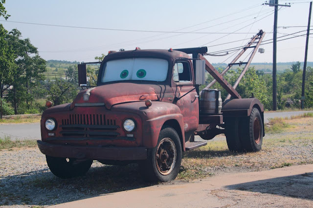
We stopped at a store in Galena, KS called 4 Women on Route 66.  They sell sandwiches, antiques, and souvenirs.  Besides being in an original Route 66 gas station, their claim to fame is an old truck parked out front.   The tow truck is the original inspiration for Tow Mater.  Apparently someone from the movies was driving Route 66 for inspiration when they were working on "Cars" and saw the old rusty truck.  The real truck is now called Tow Tater due to copyright issues (The truck was named by a little girl, the winner of a contest).

Inspiration for Cars' Tow Mater.
After Galena we drove across Rainbow Curve bridge, the last remaining Marsh Arch bridge on the route.

Rainbow Curve Bridge.
We left Kansas and entered Oklahoma.  I found the drive here interesting but the Wife soon got bored with the scenery and, for the first time this vacation, took a nap in the passenger seat.  This is very unusual.  I expected her to start napping the first day but she held out a whole three days before taking her nap.  She took her role as navigator seriously.

We stopped in Claremore, OK at Ron's Hamburgers and Chili.  This little place had some of the best burgers I've ever eaten.  They were so big and greasy that you had to eat them with a knife and fork (The buns were too soaked in grease to pick up).  I think I had a Double Jumbo Cheeseburger.

We drove by tiny gas stations, Dairy Kings, and bronco bulls on the way to our next stop: a big blue whale on an idyllic pond.  The whale was once part of an amusement park but was moved here when the park closed down.  Now it's just a roadside attraction.  We bought a magnet here.

The mouth of the blue whale.
The route takes you through Tulsa and Oklahoma City.  These cities confirmed that following the route through cities is not fun and often confusing and stressful.  In Oklahoma City we ended up going around this one loop of highway three times before we finally figured out where we had to turn.

We ended the day in Weatherford, OK.  We ate dinner at Lucille's Roadhouse - even more good food.  All this good food also contributed to my bad blood tests after I got home.

This day was a long driving day with a sprinkling of interesting things along the way.  Route markers were getting fewer and farther between but you knew you were on the right track because of all the businesses with Route 66 in their names.  Tomorrow goodbye Oklahoma, hello Texas panhandle.

These pictures as more have been added to my 2011-07 Route 66 Roadtrip Google Photos album.

Approximate distance driven this leg: 324 miles.

Wednesday, December 14, 2011

Book: Christopher McDougall's "Born To Run"

Christopher McDougall's "Born to Run" is an interesting introduction to the world of ultramarathon runners, the science behind long distance running, and the history of a Mexican tribe of runners hidden deep in Copper Canyon country.

The story roughly follows the clandestine organization of a race between Tarahumara tribesmen and elite American ultamarathoners.  The book talks about both the early history of long distance running and the history of the Tarahumara.  Interspersed in the story of the race, the Tarahumara, and the author's participation in the race are several chapters about the history and benefit of barefoot running.

I found the book interesting and well paced.  I was interested in both the race and the barefoot running chapters and the history provided a nice backdrop for the storytelling.  It was good enough to make me wonder about the shoes I wear while walking and if I may benefit from barefoot walking.  Something to talk to my physical therapist about I think.

A good read and recommended for anyone who runs and  ... like me ... those who don't but are interested in running.

Monday, December 12, 2011

Route 66 & California - Missouri

We left Val-E-Vue and headed to Camdenton where we stopped to souvenir shop.  Not finding everything we wanted (I was looking for a Lake of the Ozarks T-Shirt) we headed to the source of the lake, Bagnell dam.  While we said we wouldn't stop at fast food along the route, I did stop at a McDonald's for a plate of hotcakes.  Since we were technically off the route (Camdenton is about twenty miles off Route 66) this was technically not a violation of the no fast food pledge ... and that's my excuse and I'm sticking to it.

We made it out to the dam and shopped some of the stores around the dam.  I found a couple of cool T-Shirts and I also managed to take pictures of two more giants.  Here's one:

"What, me worry?"
Back to Camdenton and then to Ha Ha Tonka state park south of town.  I was surprised my parents never took me here ... but they may have and I just don't remember (Mom, you can clear up that one).  The park features forests, caves, glades, and miles of hiking trails but the main attraction are the ruins of Snyder's Castle.  The home, built in the early twentieth century, was going to be a private retreat for a wealthy Kansas City Businessman.  He ended up dying before it was finished.  His children finished the project and it served as a hotel until it burned in a fire in 1942.  The ruins are pretty cool and reminded me a lot of Knapp's Castle near Santa Barbara, CA.

Ha Ha Tonka "Castle"
Pictures of the Lake of the Ozark  part of our trip can be found in my 2011-07 Route 66 - Lake Of The Ozarks - Ha Ha Tonka Google Photos album.

Back in the car we rejoined Route 66 and drove through some beautiful forested scenery.  We reached the town of Marshfield, MO, hometown to Edwin Hubble, namesake of the Hubble Space Telescope.  There was supposed to be a model of the telescope in the town square.  We could not find the town square.  Being the guy I am, I refused to stop to ask for directions and, after driving around town for too long, I just left town.  This did not make the Wife very happy (my lack of willingness to ask questions is a major irritant to the Wife) and the car was a little quiet for the next twenty-something miles.  To make it worse we were in Marshfield on the day of the last Shuttle launch.  It would have been a nice tribute to the end of the shuttle era to see the Hubble replica ... if I hadn't been so pigheaded.

 Forty-some quiet minutes later we arrived in Springfield, MO.  I have many memories of Springfield.  Springfield had the closest shopping mall to where we lived.  Christmas shopping was done in Springfield ... a very important fact for a kid like me.  I remember piling in the car or pickup, (My brother and I would be in the back under the camper shell sitting on an old bus seat.  The truck was black with a white stripe and we all called it the Skunk.) heading to Springfield, and just wandering around the stores.

In Springfield we also broke the silence and started looking for a place to eat, settling on a Steak & Shake with the word "TAKHOMASAK" painted on several sides of the place.  Being a lover of ice cream, I am a little embarrassed to say that I had my first shake here.  Yes, it took 48 years for me to have my first shake (Chocolate Chip Cookie Dough flavored).  When I was a kid one of my many eccentric food weirdnesses was not liking soft melted ice cream (soft serve was fine).  I wasn't fond of the "chocolate soup" so I think a shake never appealed to me.  My tastes have changed a lot over the years and I am glad to say that I liked my shake and the accompanying burger.

Out of Springfield the route diverges from I-44 and takes you through beautiful country landscapes and little towns.  In the small town of Halltown, MO we stopped at the Whitehall Mercantile, a small antique/junk store.  We looked around - I don't remember buying anything - and we checked out the guestbook.  Just about all of the restaurants and small stores we stopped at along the route had a guestbook.  The Whitehall Mercantile book, a typical one, amazed me.  It was full of people from all over the world.  It reminded me of the albergue guest books.  There seemed to be more European names than American.  A lot of Norwegians.  I guess if you want to see typical America then driving Route 66 is a great way to do that.

We got back in the car and started to back up and we heard a terrible screech coming from the front-passenger side wheel.  It only happened when we made a turn and went away when we drove straight but when it went off it sounded like our wheel was going to fall off or like we were dragging some metal on the ground.  It persisted as we made our way down the route.  I was thinking bad bearings or something.  I was also hoping it would just go away.  After making a stop to take pictures of the "Crap Duster", we bypassed a part of the route to speed our arrival to Joplin.

"Crap Duster"
We stopped at a gas station and asked for directions to the nearest Honda dealer.  We drove north and the world changed around us.  We went from a typical large town to a devastated war zone.  This spring a tornado ripped through Joplin killing 159.  The destruction we drove through was total but the signs of people rebuilding were everywhere as well.

We reached the Honda dealership and were lucky enough to get there before the last mechanic had left for the day (We were also lucky it had not been damaged by the tornado).  I drove the mechanic around the parking lot ... screeching all the way.  It took less than twenty minutes to fix.  It turned out a small rock had got stuck in the brake mechanism and it had fallen out as soon as he took off the wheel.  We weren't even charged anything.  The Wife and I were both relieved.

We found a hotel and checked in.  We asked the desk clerk about any locally owned restaurants that he could recommend.  He said he once knew of some places but after the tornado "They aren't here anymore." We ended up eating at a steak house that was a local chain (I think we ate at one in Nebraska during our Sandhill Crane viewing).

Joplin turned out to be a sobering end to our driving day.  I have added these and other pictures to my 2011-07 Route 66 Roadtrip Google Photos album.

Approximate distance driven this leg: 232 miles.

Thursday, December 08, 2011

Route 66 & California - Illinois & Missouri

We left Litchfield and headed to our next destination along the route.  In the town of  Stanton, IL we stopped at Henry's Rabbit Ranch & Route 66 Emporium.  Think a small carhenge with VW Rabbits ... and real rabbits. I took pictures and we talked to the owner (He nearly talked our ears off).  We bought some magnets in his store and pet the rabbits wandering around the store.  He gave us a free gift (I think it was a pen) because we were driving Route 66.

The Rabbit Ranch. - Buried VW Rabbits.
We crossed into Missouri near St Louis and stopped at a park.  At the park the old route 66 Chain of Rocks bridge still crosses the Mississippi river and is now a hike/bike trail.  We walked part way across the bridge looking at various route 66 displays along the length of the bridge including an old (vandalized) fire truck.  The bridge was also the habitat of birds of prey that screeched as we walked by their perch.  It sounded like the bridge creaking.  From the bridge you could see two 'buildings' in the river.  I later found out they were "water towers" that once supplied water to St Louis.  One of them look like it would make a cool little house.

Chain of Rocks bridge - crosses the Mississippi river with a turn in the middle.
We left the bridge and, on our way through St Louis missed a turn and ended up driving miles out of our way until we realized out mistake and, checking the map made it back to the route.  Sadly our inadvertent detour made us miss Ted Drewe's Frozen Custard stand and the "concretes" that have been sold here since 1941.  It would have been my first frozen custard ... I still haven't had a frozen custard.  We discovered that following route 66 through cities was the worst as the route had changed the most in cities and often resulted in a twisty, turny, and confusing course that was easy to lose your way on.

World's largest rocking chair near Fanning, MO.
We stopped for lunch in the Lewis Cafe in St Clair, MO.  This turned out to be another great local place with awesome food.  We stopped at the world's largest rocking chair near Fanning, MO where I bought one of the few ice creams along the route (I kept the ice cream and candy to a minimum and was very well behaved).  We passed by a giant hillbilly swinging his arms.

Giant hillbilly with spinning arms.
We eventually left the route to head north-west toward Camdenton, MO and the Lake of the Ozarks where I lived the first nine years of my life in the 60s and early 70s.

We arrived to Camdenton and drove passed my grade school then headed to my old kindergarten.  I almost missed the turnoff to the old school.  I had trouble recognizing the place.  The old kindergarten is now a county museum.  It was closed when we got there but a man sitting on the steps told us that they were rehearsing some play in the gym and that we could walk through the museum if we wanted.  So we had a little private walk through.  It was a little strange.  I almost couldn't find the old school building but once I was inside I recognized my old classroom which I hadn't seen since 1968, forty-three years ago.

My kindergarten, now a museum.  I wonder what that means?
We stopped for the night at a place dear to my heart, the Val-E-Vue resort on the Lake of the Ozarks.  Yes, that's where I get my email address from.  It was my home from the day I was born to just before my ninth birthday.  I'd been back a few times since we moved in 1972 but the last time was in 1985 or 1986, almost twenty-five years ago and this was the first time I'd stayed at our old resort.  We checked in to Cabin #4 and asked the young man who checked us in where a good place to eat was.  He suggested Captain Ron's Bar & Grill.

On the way to the place I was amazed at what I didn't remember.  Things had changed so much
in the last twenty-five years.  It was like I was on a whole different planet but then I would see something I recognized and memories would flood back.  Captain Ron's was on the beach.  The bar was outside but we sat in the restaurant and had some good food which I followed with Triple Chocolate cake (Chocolate cake, mousse(!), and frosting).  It was yummy.

The old swimming dock at the Val-E-Vue resort.
We returned to Val-E-Vue and I walked around to see how things had changed.  The water level was high as water was let out of the dam every spring.  The old barn we used for storage, and I thought was haunted, had been torn down.  Several old and new buildings had been victims of a heavy snow a year or two back.  There were new docks and a few old ones including the swimming dock that was now a shadow of it's former self without its slide and diving board.  Our old house had burned down in the late 70s or early 80s so I knew it wasn't there anymore.  The basement had still been there when I was there last and was still being used as a rec room at that time, but it was totally gone now replaced by a trailer.  Generally the place was starting to look a little run down.

The whole lake scene was slow this year and the resort only have two parties staying there at the end of the 4th of July week.  The resort felt like a ghost town compared to when I was a kid.  The economy was impacting the lake.  The huge number of condos and rental houses that had gone up in the last forty years also had taken its toll on the resort business.  I could understand, with the economy as it is, how it would be hard to keep the place up.

Sunset over the Lake of the Ozarks.
Things were so different and yet felt so familiar.  The woods I played in, the shores I followed looking for treasures that had washed up, and the lake that had always been there, unchanging, a constant in my young life - they were all still there but the material things made by Man had changed almost beyond recognition.  When I think back to the good old days it's to the years on the Lake of the Ozarks.  I was at the carefree, no responsibility years.  I know this was a hard time for my parents.  Money was always tight and running a resort is not an easy thing to do for a young family but I rarely saw that.  I have to thank my parents for that and, in hindsight, they made my years on the shores of the Lake of the Ozarks some of the best years of my life.

Pictures of this leg have been added to my 2011-07 Route 66 Roadtrip and 2011-07 Route 66 - Lake Of The Ozarks - Ha Ha Tonka Google Photos albums.

Approximate distance driven this leg: 286 miles.

Wednesday, December 07, 2011

Book: Iain M. Bank's "Look To Windward"

As I read more of Iain M. Bank's Culture novels, I am finding myself warming up to his style.  While the other Culture books held my interest but were a little lackluster at times, the latest book, Iain M. Bank's "Look To Windward" held my interest and was a good read ... definitely an improvement.

The book follows a plot involving love lost, revenge, justice, and redemption.  A civilization, once thrown into a planet-wide civil war by Culture meddling, seeks justice through a plot that would result in the loss of billions of Culture lives.  The weapon of destruction is a man who lost the woman that he loved in the civil war.  He embarks on a suicide mission that fails.  In the end his own personal mission, to end his life, a life not worth living without the woman he loved, is accomplished when he joins with his target, a sentient computer (known as a Mind) in charge of a huge space habitat.  The Mind - who once participated in a war where two stars, along with all the life orbiting them, were destroyed - has lived with guilt for over a thousand years.  After a few thousand years of guilt the Mind saves the lives of billions but joins with the assassin in a pact of mutual suicide.  The end of the book hits the right note of redemption and living, or dying, the way you wish.

The book is well written, interesting, and recommended.

Monday, December 05, 2011

Route 66 & California - Illinois

If you're going to drive Route 66 and want to stay as faithful to the original route as possible, you need a good guide book.  We used Jerry McClanahan's "EZ 66 Guide For Travelers 2nd Ed".  The spiral bound book gives turn by turn directions, descriptions of historical places and sights along the way, and recommended places to stop along the route.  The route is well marked in Illinois with Historic route 66 signs along the way similar to this (I drove the whole thing and didn't once take a picture of an official sign ... what was I thinking?  This picture is a scan of a magnet):
We left Chicago with the guidebook in the hands of the Wife, an excellent navigator, and headed down the mother road.  We knew there was a lot to see along the route and that we couldn't stop at everything of note along the way.  We decided that we would try to be picky and avoid most museums and concentrate on the stranger attractions and oddities along the route instead.

Our first stop was the Gemini Giant (The guidebook has several "Giant Alerts" along the route).  The Gemini Giant is an old Muffler Man with a few space related accessories added on.  We stopped to take some pictures and get some lunch at the Launching Pad Drive In.  Sadly, the drive in was closed.

The Gemini Giant.
We ended up eating at the Old Log Cabin restaurant in Pontiac, IL.  The restaurant dates back to 1926 and served some good food.  This was the beginning of something I hadn't expected ... though I should have ...  Route 66 was becoming a foodie vacation.  We'd decided early on to not stop at any fast food places along the route until we'd reached the end.  It was similar to the no fast food pledge I made myself when I walked the Camino.  We would try our best to eat at locally owned diners and restaurants along the way.  Now I wish I'd journaled about where and what I ate along the route.

Along the road we passed by the birthplace of Colonel Blake (A MASH character and also the birthplace of the actor who played him) which also happens to be the world's only source of Beer Nuts.

The next Giant Alert was in the town of Atlanta, IL where we discovered a Paul Bunyon holding a hot dog ...  I have no idea so don't ask.

A Paul Bunyan holding a Hot Dog ... What?!?
We arrived in Springfield, IL and visited Abraham Lincoln's tomb and presidential library.  Both were impressive.  People left pennies on every statue in the monument and we added one or two ourselves.

Lincoln with your nose so bright, won't you guide my sleigh tonight ...
Our next stop was for the Wife: "Our Lady of the Highway".  It was supposed to be south of Waggoner.  After driving south, west, east and north of Waggoner, a tiny half-horse town, we gave up and continued further south ... and there it was.  In the front yard of a farm house was a shrine with a Mary statue.  Signs along the route recited the Hail Mary.  We stopped and took pictures.

Our Lady of the Highway.
We ended the day in the town of Litchfield, IL.  We ate at the Ariston Cafe (built in 1931).  We had our second awesome meal of the day there.

Our first day on the route was exactly what I expected.  A lot of quiet driving, interesting sights, small towns, lots of turn left-turn right, and a few weird things in between.  What I didn't expect was the feeling I had as I drove along the route.  In my head I was still on the Camino and the route, while by car instead of by foot, felt like a continuation of my pilgrimage.  Statues, memorials, historic guideposts, Mary, natural beauty, and ...

Route 66 Pilgrim's Shell.
These pictures and more have been posted to my 2011-07 Route 66 Roadtrip Google Photos album.

Note: While I did record GPS tracks along the way, I didn't start the GPS until I took the first picture.  This resulted in incomplete tracks.  I just didn't think I would want to include maps and stats for a driving vacation.  After including stats and tracks in my Camino posts I realize I made a mistake on the Route 66 roadtrip.

Approximate distance driven this leg: 260 miles.

Thursday, December 01, 2011

Route 66 & California - Beginning At The Beginning

I arrived back home from Spain late in the evening, Tuesday, 28 June.  Four days later we climbed in the car and left on our summer vacation.  The vacation would take us to my In-Law's lake house in Iowa, along the entire length of Route 66, up the coast of California to San Francisco, and back - over three week's time.

Route 66 - the Will Rogers highway, the Mother Road, the Main Street of America - runs roughly 2,448 miles (3,940 km) from Chicago, IL to Santa Monica, CA.  The route, established in 1926, passes through eight states and innumerable small towns.  I'd wanted to drive it for a long while and I was happy that the Wife also thought driving the route would make for a great vacation.  It would be somewhat of a challenge as we'd discovered a while back during our first vacation as a married couple that car trips over ten days were stressful and this vacation would be twenty-two days long with fourteen of those being driving days.

Before we actually started Route 66 we were stopping at the In-Law's lake house on Lake Cornelia.  We spent three days there enjoying ourselves at the lake and celebrating the fourth of July with the annual boat parade and fireworks.  I told stories of my Camino (the first of many tellings over the next few months) and relaxed the best I could.  I was still a little high from my experience in Spain and my body was trying to recover and, I suspect, having withdrawals from the 1,600 mg of Ibuprofen that I took every day while I walked the Camino.  The craze at the lake this years was the mini-hot air balloon.  You could see them being launched all around the lake and we launched a few of our own.

Hot air balloon being launched at Lake Cornelia.
On the fifth of July we drove east.  We stopped in the town of Galena, IL for lunch.  This is one of our favorite towns (along with Cambria, CA and Stillwater, MN).   I always marvel at the stairs coming down the bluffs into the downtown area - reminded me of the Camino.

Stairs in Galena, IL.  Reminded me of the Camino.
Our destination that day was Chicago, the start of Route 66.  We stayed in a hotel on Grant park only a couple blocks from the official start of the route.  After settling into our room we went down to the lobby.  The Wife went up to the front desk and asked what there was to do within walking distance.  The hotel clerk told us about museums, restaurants, and stores in the area.  As he was doing this another visitor was checking in and the other clerk asked him if he was here for the concert.  "What concert?"  we asked, thinking it might be some free summer concert in Grant park.   "U2" he said, "do you want to go?"  We laughed and said "Sure but we don't have tickets."  "There's a guest in the hotel who is trying to sell a couple tickets.  Do you want me to call him?"  he said.  "Heck yeah!"  we said.  We met with the gentlemen (from New Zealand, I think) who appeared to be a hard core U2 groupy.  He quizzed the Wife (I think he wanted his tickets to go to real fans) and, being satisfied with her answers, sold us two floor tickets for face value ($54 a piece - not a bad price at all).  WHAT!?!  What just happen?!? 

We walked over to Soldier Field where the concert was and went in.  We bought some food and headed down to the floor.  We kept looking at each other and grinning from ear to ear.  WHAT!?!  (That became our reaction to just about everything on this vacation - WHAT!?!)  This concert had been sold out and we didn't even know it was that night and it just kind of fell into our laps.  WHAT!?!

The concert started with Interpol warming up for U2.  They were pretty good but I was only familiar with a few of their songs.  Next U2 came on and it was crazy awesome.  A great concert.  Up there with Green Day and the Eagles.

Near the end of the night it was starting to get really hot.  We'd been standing (no chairs on the floor) for about five or six hours and as the night progressed the people on the floor had slowly pressed towards the stage until we were all packed in like sardines - hot sweaty sardines.  By the last encore it was too much for us and we made our way to the edge of the crowd so we could try to cool off.

As we got close to the wall I saw the Wife was in bad shape.  I got her sitting on the floor, back to the wall, and asked someone for water.  When no one came through I bought a bottle and got her drinking.  By this time first aid arrived and we were helped to the first aid station where we encountered Nurse Mary.  She was all business and no nonsense.  She got the Wife on a bed, checked her vitals, and asked her questions ("What day is today?").  She handed the Wife two bottle of water and said "Drink these and pee.  If you don't pee, you go to the hospital."  It wasn't easy but the Wife finished the two bottles (three including the one I gave her) and did what she was told.  Nurse Mary didn't seem to believe the Wife but, after signing away all liability, she let us go.  This whole incident was a flashback of the start of our first roadtrip together.

We walked ... slowly ... back to our hotel.  It was a little scary there for a bit but, despite the heat stroke,  what a marvelous way to start the route.