Homer's Travels: September 2019

Friday, September 27, 2019

Appalachian Trail: Pinkham Notch To US 2 (Gorham, NH)

🐻 x 6
🦌 x 1
UPDATED 12-05-2020

I've been wrestling with a decision for weeks.  I bet you know what that decision was.  The final decision clicked into place during this section of the Appalachian Trail (AT) and a choice became clear.

The fall colors in the White Mountains.
Day 175 - I was dropped off at Pinkham Notch and I started up the Wildcat Mountains.  I'd woken up a bit bummed this morning and I felt a bit emotional as I climbed the steep rocky trail.  I think it was running into George that did it.  I realized that everyone I met in the south and cared about were either forever ahead of me, had flip flopped and I'd met them going south (like Sista', Tarzan, and George), or had already quit the AT (Salamander, Ruckus, Day Glow, Lumberjack, Jug, Phoenix, Red Bush).  This made the trail feel incredibly lonely for me.  Combining this with the fact my body simply wasn't recovering every night like it did down south and I missed home, the pieces clicked into place and the choice was clear.  I was going to quit my AT thru-hike attempt.

I arrived at the Carter Notch Hut.  The Hut was transitioning from summer full service to winter self service.  They let me and a couple other thru-hikers sleep in the bunk room.

In better weather the colors would
have reflected in the pond.
Day 176 - I crossed the Carters - Carter Dome, Middle Carter, and North Carter mountains. Despite having over ten hours of sleep I had little energy. Every rock, every labored step reinforced my decision to quit.

There were few views today due to low clouds and fog but occasionally I got glimpses of the fall colors.  The reds, oranges, and yellows always made me smile despite how tired I felt.

I reached the Imp Shelter.  My goal was five or six miles farther ahead but I couldn't do it.  I stopped at Imp for the night.

Day 177 - I slipped three times on my last day on the trail.  After I crossed my last mountain, Mt Moriah, I was heading mostly down hill.  The trail went from rocky to not so bad dirt/rock/root mix.  It's these nicer trails that get me.  I lower my defenses as I push myself to move faster.

The early morning light on my last day on the AT.
The first two slips were minor.  A banged knee here.  An overextended knee there.  A few bruises.  The third was a bit more ironic.  I was rushing the last two miles because I wanted to beat the coming rain and be dry when I got to the hostel.  I reached a stream.  The bank was a broad smooth granite shelf.  I approached the edge intending to step down when my feet went out from under me.  I ended up sitting in six inches of cold water.  The only casualty was a smacked funny bone that numbed my left arm.   My pants sort of dried by the time I got to the hostel.

The slips and falls I've been having lately just reinforced to me that it was time to come home.

The AT gave me a parting gift though.  I heard a noise ahead and a large moose with a full rack came out on the trail ahead of me.  It moved away from me before turning off trail.  It paused to look at me before it went deeper into the woods.  Sadly, no pictures.  Also sadly there is no moose emoji so I had to use a deer head in the counter at the top of the post.

More about my leaving the AT in my next post.

Pictures can be found in my 2019 Appalachian Trail Google Photos album.

Total Distance: 1,893.7 Miles (3,047.6 km)
Section Distance: 20.2 Miles (32.5 km)
Section Elevation Up: 7,311 ft (2,228 m)
Section Elevation Down: 8,164 ft (2,488 m)


Tuesday, September 24, 2019

Appalachian Trail: Lincoln, NH To Pinkham Notch

🐻 x 6
UPDATED 12-05-2020

The words of the week are Vortex and Brutal.
  • A Vortex is a trail town that sucks you in and won't let you go.  Lincoln, NH was a vortex for me.  
  • Everyone I talked with in the Whites used the same word to describe the trails: Brutal.  I can't come up with a better word.  The trails were truly sadistic.
The difficulty of the trail during the last five or six days was several orders of magnitude greater than what I've experienced on the Appalachian Trail (AT) or any trail I've hiked.  Parts of the descents were potentially life threatening where a trip or slip could lead to a serious or lethal head injury.  I questioned and still question if this was worth the risk.  But … for some reason I hike on.

On my way to Mt Lafayette.
Day 167 - To reduce the amount of food I was going to have to carry I decided to slack pack the Kinsman Notch to Franconia Notch segment of the AT.  This would be my first slack pack.  Slack packing is hiking without a pack.  You carry only water, water treatment, and snacks.  You still walk the distance but you are carrying a lot less weight.  Since this was my first time I would be doing a relatively short day to feel out how much easier it actually is.

It turns out that it really doesn't make it that much easier.  At the start I felt less stress on the joints which was welcome.  What it didn't do was allow me to hike faster.  Half way through I realized I was going to get to Franconia Notch at or shortly after sunset.  The rest of the hike was a forced march down a rocky trail in a race against the fading sun.  Needless to say my first slack packing experience was not very fun and stressful.

On the way down from North Kinsman Mountain my left knee began to hurt.  Eighteen hundred miles and now my knee starts to hurt.  At this point I started to ask why I was doing this.  Had my body reached its physical limits?  Was it time to go home?

I arrived at a parking lot just as the last light of the sun was fading.  As I pulled out my phone to call a shuttle a car pulled up and asked if I needed a ride to Lincoln.  I said sure and they took me back to my hotel.  Trail magic.

I called the Wife to talk about my thoughts.  She encouraged me to keep going.  I was not totally convinced that keeping going is the right option but continue I will … for now.

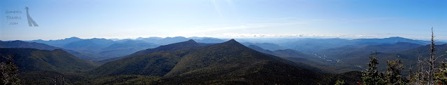
The mountains go on forever.
Day 168 - I was supposed to continue hiking today but decided to risk not making it to Katahdin in time and took another zero day to let my knee rest.  Lincoln turned out to be my vortex, sucking me in and not letting me go without a struggle.  (Looking back with hindsight I probably didn't need that extra zero day and I was just looking for an excuse not to hike.)

Even panoramas can not capture the sweeping views.
Day 169 - I made it out of town.  My shuttle dropped me off at Franconia Notch and I headed up Franconia Ridge.  It was a beautiful day and the views once you got up to the top of the ridge were awesome.

The climb up Little Haystack Mountain, Mt Lincoln, and Mt Lafayette went well. The difficulty started when you descended Lafayette.  The rocky descent slowed me to a crawl and the knee pain returned.

After one last climb and decent of Mt Garfield I arrived at Garfield Ridge Shelter.  It was a ten mile day and I got there just before dark.  It was a cold night with a frost advisory.  I stayed warm in the shelter.

There was a hiker there without a tent.  He was planning to sleep under the shelter but we convinced him to move in with the rest of us in the shelter.

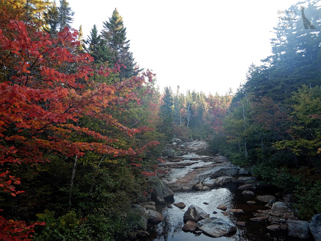
Yes, fall colors are making an appearance.
Day 170 - My goal was the Ethan Pond Shelter around fifteen miles ahead but I knew I wouldn't make it.  There was only one climb. But I learned that in the Whites the descents were the hard part that slowed me to a crawl.  Sure enough, the descent from South Twin Mountain sucked the life out of me.

I stopped after less than ten miles at the Zealand Falls Hut.  The huts are run by the Appalachian Mountain Club (AMC).  They are beautiful cabins/lodges with running water, some solar electricity, and food.  They are also expensive.  Fortunately the AMC offers a few spots for thru-hikers to work for stay.  I washed dishes and was allowed to eat cold leftovers and to sleep on the floor once the paying guests went to bed.   The food was excellent.

Along they way to my first hut, as I climbed a steep rocky trail, I was passed by a girl in a pink tutu and a guy.  They were practically running down the hill.  I silently cursed their young, fearless bodies.  I would later find out that they were volunteers at the huts racing the White Mountain Hut Traverse a forty-nine mile race going from hut to hut.

A few of the hut volunteers went out overnight to raid, and steal the mascot from, another hut.  These volunteers seem like a fun bunch.

That night the stars were out in force but once again it was too cold to loiter around staring at the stars.  I slept well once the class of middle schoolers finally quieted down.

How many colors do you want?
Day 171 - I was told that the Ethan Pond Trail, which the AT follows, was going to be an easy hike.  I've learned to take these comments with a grain of salt.  Nevertheless I planned for a longer day.

I left the hut and soon joined the Ethan Pond Trail.  Wow.  The trail was smooth and rock free.  It climbed slowly over seven miles or so.  I blazed through this section averaging over two miles per hour for the first time in a long time.  I was bummed when the trail returned to its rocky ways.

The extra speed gave me time to climb Mt Webster and Mt Jackson in time to arrive at Mizpah Springs Hut.  I decided to shell out the fee and get a bunk and hot meal here.  After eating a great meal I went to bed early.  My bunk room in this three story hut was empty.  It was nice to have a quiet and warm place to sleep.

The sun is struggling to get through the clouds.
Day 172 - This was going to be a big day.  I was going to knock off most of the Presidentials today.  I was getting ready to leave before breakfast when the cook (the hut cook rotates through the hut's four "croo" members and is also the person in charge that day) asked if I wanted some pancakes to go.  She bagged up four pancakes and I put them in my pack for later.

The day started foggy and cloudy. There were hardly no views for the first five miles.  I stopped at the Lake of the Clouds Hut to use the privy and to refill my water.

I'm heading for those mountains.
As I climbed up Mt Washington, the highest of the Presidentials, the clouds cleared out and the sweeping views returned.  At the top it was crowded.  You can drive or ride a short two car train up to the top.  The line in the restaurant was too long for me to get anything so I bought a magnet and started back down the other side of Mt Washington.

The next six miles were a slow, rocky slog up, down, and around mountains.  I snapped off another trekking pole and smacked my right knee on a rock in the process.  I was able to repair my pole somewhat but my knee bruised and would hurt the next few days.

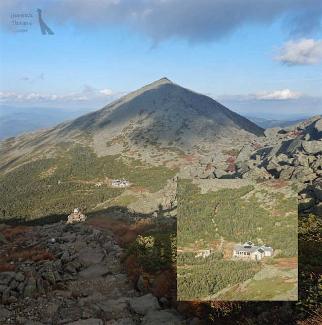
The Madison Springs Hut at the base of Mt Madison.
I arrived at the Madison Springs Hut.  I ended up paying a small price for cold leftovers and a space on the floor.    The food here, like all of the huts, was excellent.  This hut was also full of kids.

I shared the floor with two non-AT hikers.  One girl was doing the forty-eight mountain challenge doing the forty-eight tallest mountains in New Hampshire.  She was curious about the AT and we shared our hiking experiences.

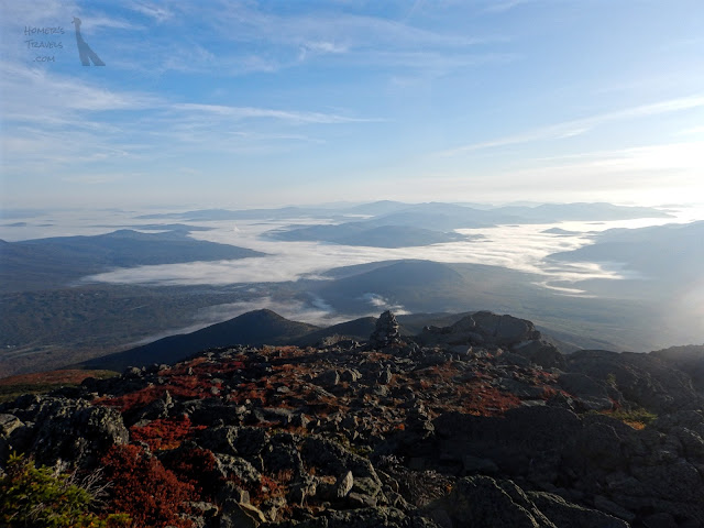
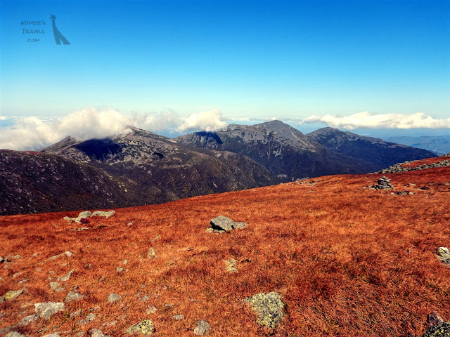
The view from Mt Madison.  That is fog in the valleys.
Day 173 - I got out early and headed up Mt Madison.  The climb up was rocky and slow but relatively short.  The views this day were gorgeous.  The forty-eight mountain challenge girl joined me here briefly.  We said our goodbyes as she headed back the way she came and I took the AT down the other side.

The way down was brutal.  I felt like I was constantly starting to fall.  I'm not sure if my sense of balance was working properly.  I averaged a half a mile an hour down this rocky, sadistic trail.

Part ways down I ran into Tarzan and Sista' who had flip flopped (jumped north to Katahdin and then hiked south).  We chatted a while before my struggle to get down the hill continued.

Despite the yellow arrow, the Appalachian Trail is not the Camino de Santiago.
The trail finally calmed down and I started to make up some time.  I was maybe a quarter mile from Pinkham Notch when I approached a bridge over a creek.  The bridge was wide, flat, and had no railing.  My thoughts were elsewhere when my foot caught on a rock.  I was going down hard.  I thought I would land on the bridge but then realized I was going over the side. At some point while I was diving head first off the bridge my leg hit the edge of the bridge which caused me to flip.  I landed flat on my back in the rocky creek bed.  My backpack cushioned the fall - it felt like I was landing on a marshmallow.  I ended with a nasty bruise just under my right knee and abrasions on the back of my right hand and right shoulder where I probably hit a rock.   I was lucky.

I got to the Pinkham Notch visitors center and called a hostel for a pick up.  At the hostel I found George who I hadn't seen since Harper's Ferry.  She'd been stuck in the hostel vortex for twelve days.  We hugged and smiled our way through our reunion.  She had flipped at Kent, CT and would be heading south … eventually.  She was not only completing her AT but also hiking home to North Carolina.

Day 174 - I expected to be sore from my fall when I woke up but the swelling near the bruised calf had gone down and, while stiff, I was not as achy as I thought I would be.

I chatted with George about people we knew in common. Ruckus quit after cracking some ribs wrestling.  Salamander succumbed to home sickness at the one thousand-four hundred mile mark and had quit.  Jug and Phoenix ran out of money in the Shenandoahs.  Day Glow and Lumberjack realized they were fighting more and quit before it could hurt their marriage.  I was both surprised and saddened that I had survived them all.   

I took the hostel's free shuttle to Walmart for resupply.  I changed my plan slightly adding a day.  I'm not sure how easy or hard it will be.  I'm hoping it will be a little easier than what I just went through.  Southwest Maine is not supposed to be easy but I can't imagine anything harder than the Whites.

Pictures can be found in my 2019 Appalachian Trail Google Photos album.

Total Distance: 1,872.6 Miles (3,013.6 km)
Section Distance: 69.1 Miles (111.2 km)
Section Elevation Up: 22,961 ft (6,998 m)
Section Elevation Down: 23,098 ft (7,040 m)

Note: The extra blue line pointing to Lincoln was due to me
forgetting to turn off my GPS on my slack pack day.

Monday, September 23, 2019

Happy First Day Of Autumn!!!

I want to wish everyone a very happy first day of Autumn.  The fall is one of my favorite as the leaves change and the air turns crisp.

It's kind of hard to see but many of these leaves are bright red and orange.
The turning of the leaves is becoming more apparent here in New Hampshire.  While it is hard to see in many of my Appalachian Trail photos there is more and more color decorating the mountains.  I can't wait to see what's to come.

Happy fall equinox everyone!!! 

Tuesday, September 17, 2019

Appalachian Trail: Hanover, NH To Lincoln, NH

🐻 x 6
UPDATED 12-05-2020

I'm approaching the White Mountains.  This is possibly the most difficult part of the Appalachian Trail (AT).  High elevations, rocky climbs, and few opportunities to resupply.  The first of the Whites, Mt. Moosilauke, was a positive preview that I hope carries through the rest of the Whites.

A view of the mountains to come.
Day 160 - I slept in a bit and had breakfast before checking out and going to the post office next door.  I picked up the replacement segment for my broken trekking pole and I was ready to go.

Since I was leaving late I planned a short day to Moose Mountain Shelter.  I was later joined by thru-hikers Luna and Early Bird.

You want me to climb that?!?
Day 161 - My next target was the Fire Warden's Cabin on the top of Smarts Mountain.  This would be another short day.  Despite the shortness of the day it was still difficult due to all the climbing involved.

I arrived at the cabin and settled in.  I was tired.  I didn't feel the extra calories I'd been eating after leaving town.  I was just as pooped as before.

The sun started to go down and I was alone in the cabin.  This was a surprise as I'd expected not be alone.  I set up my sleeping pad in a corner and went to bed early.  I woke up when I heard the rain and was happy to be in a dry and fairly warm place.

Mushrooms?  Eggs?  Easter Bunny poop?
Day 162 - My lack of planning caught up with me.  Mt. Moosilauke, the first of the White Mountains, was approaching and the short days I'd just done hadn't put me in a good position to tackle the climb.  I had to go as far as I could to get close to the base of the mountain.

I ran out of steam at the base of Mist Mountain.  I'd hoped that I would at least reach the top of this shorter mountain.  I stealth camped near a creek at the bottom.  While I was eating dinner I stepped on a ground bee's nest.  In the mild chaos I was stung on my neck.

The trail leads to Mt. Moosilauke straight ahead.
Day 163 - I climbed up and over Mist Mountain and reached the base of Mt Moosilauke.  I filled my water bottle and added some caffeine.  I'd been off caffeine for a couple weeks but I figured the 3,800 ft (1158 m) climb needed an extra boost.

The climb up the south side of the mountain was surprisingly gentle.  It went straight up the mountain for a while before becoming a rock climb.  The rock climb ends at a narrow ridge that leads you to the last four hundred foot climb to the summit.

Follow the cairns.
Rock cairns lead you above the tree line to the summit.  The drizzle that I walked through in the morning was gone and a cold wind blew at the top.  The views from Moosilauke were pretty awesome and were a preview of the views coming in the rest of the Whites.  More surprising was the fact that I felt really good.  I am guessing that the caffeine with the higher calorie intake worked together to power me up the mountain.

It was windy and cold at the summit.  I sat and talked to a couple day hikers before heading down the North side.  The trail started out muddy before turning steeply down a rocky trail.  This really slowed me down.  Part way down, just past the 1,800 mile mark, I turned off the trail and stopped at the Beaver Brook Shelter.  I was only a mile and a half away from the road where I could catch a shuttle but it was still a 1,800 ft climb down a very rocky trail.  Stopping at the shelter was the wise choice I think.

I was joined by Early Bird in the shelter for a very chilly evening,

Days 164, 165 & 166 - I slept in a bit - it's hard to get out of your sleeping bag when it's cold.  It took me nearly two hours to climb down to the parking lot and Kinsman Notch.  I called a shuttle and headed into Lincoln, NH.

I took two zero days after the nearo into town.  I wanted to give my body a really good rest prior to tackling the Whites.  I also resupplied and got a haircut.

I'm off to the Whites. My original plan had three days to get to Gorham, NH.  Since I expect the Whites to be more difficult I am adding a day and, in a way, winging it.  It will be challenging and interesting … and a bit scary too.

Pictures can be found in my 2019 Appalachian Trail Google Photos album.

Total Distance: 1,802.6 Miles (2,901.0 km)
Section Distance: 53.4 Miles (85.9 km)
Section Elevation Up: 15,894 ft (4,845 m)
Section Elevation Down: 14,193 ft (4,326 m)


Monday, September 09, 2019

Appalachian Trail: Killington, VT To Hanover, NH

🐻 x 6
UPDATED 12-05-2020

This last section was short which was better for my worn out legs.  I increased my calorie budget and felt pretty good.   I'm feeling pretty good and my mood has improved.  Twelve states are behind me and only the two hardest states remain.

Kent pond.  I just want to sit and dangle my feet.
Day 156 - I hiked out of Killington and rejoined the Appalachian Trail (AT).  The trail passes Kent Pond and Mountain Meadows Lodge.  I considered zeroing at the lodge but it is closed for renovations and you could see the work being done to the exterior.  The dock on the pond just begged to be sat on with your feet dangling.

Like the rest of Vermont there were several hills to climb on this day.  The trail designers in Vermont don't believe in proper switchbacks and most of the climbs are straight up the mountain.

Today was going to be a sixteen mile day but, after talking to some southbounders (including one recording his thru-hike for Google Street View) said I had to stay at the Lookout Cabin.  I'd also considered shortening the day so I would have three even days of fourteen miles each.

I reached the cabin and ran into Hemingway, a thru-hiker I hadn't seen since Hot Springs, NC one hundred and twenty days ago.  Strange how the trail works.

The sunset colors light up the clouds.
The cabin was near the top of a mountain and had a small platform built on the top of the roof.  Climbing a ladder to the platform gave you a 360° view.  Hemingway, a few other thru-hikers, and I watched the sunset from the best seat in the house.

The oranges and yellows of sunrise.
Day 157 - Hemingway is an earlier riser than I am.  I slept in a little since sunrise is slowly getting later.  I got up and climbed the ladder for a view of the oranges and yellows of dawn.

The hike today took me past three farm stores.  I decided to skip the first two and visit the third.  Turns out I did that totally backwards.  The first two had hiker-centric products while the third was all high-end snooty-centric.  I did buy a pint of snooty organic ice cream.

I made it to my stop at a reasonable time.  My hiking speed was comparable to my speed down south.  There are a couple of potential reasons for this.  The trail conditions in Vermont are similar to Virginia with fewer rocks.  I also increased my calories per day.  Both of these may explain the extra speed.  I hope this continues into New Hampshire.

Another milestone to lift my spirits.
Days 158 & 159 - One more Vermont hill climb before I got into town.  Before starting up the hill I passed through West Hartford, VT.  The AT passes by a hostel.  One of the owners waved me down and offered me a snack.  I rested, ate cupcakes, a banana, washed it down with juice, and chatted with the owner.

The hill felt tough as I expected.  The trail comes out on a road south of Norwich, VT and becomes a road walk for the next two and a half miles.  Not far down the road a homeowner had placed two Adirondack chairs with a mail box with a log book and Tootsie Rolls. Another house farther down the road had a large jug of water near the curb for hikers.  The AT skirts Norwich, crosses the Connecticut River (the VT-NH border), and goes up a hill to the Dartmouth campus.

I spent way … way … too much for a hotel room.  Despite the cost they didn't have guest laundry.  I took an Uber to do laundry.  The next day I took another Uber to Walmart and resupplied.  I boosted the calories again which means it will be a heavy haul when I leave town.  I was also hoping for a haircut but, being the weekend, everything close to the hotel was closed.  Weekends often threw monkey wrenches into resupply plans.

Today, after picking up a piece to fix my broken hiking pole at the post office, I'll head for the next town, N. Woodstock, NH, the beginning of the White Mountains.  The Whites are considered the most difficult part of the AT and also the most spectacular … and they are only four days away.

Pictures can be found in my 2019 Appalachian Trail Google Photos album.

Total Distance: 1,749.9 Miles (2,816.2 km)
Section Distance: 46.1 Miles (74.2 km)
Section Elevation Up: 11,365 ft (3,464 m)
Section Elevation Down: 12,322 ft (3,756 m)


Thursday, September 05, 2019

Appalachian Trail: Bennington, VT To Killington, VT

🐻 x 6
UPDATED 12-05-2020

I knew the next few days were going to be tough.  I don't think I knew how tough.  I managed to meet my goals but I had to reduce some of my goals to make it.  As I add extra days to reduce my daily miles and zero days to let my legs recover I am creeping closer to the point of no return or, more correctly, the point of no finish.

The sun sets over a beaver pond.
Day 149 - One of the hotel staff dropped me off at the Appalachian Trail (AT) trailhead just before 7:30am - about an hour later than I usually start hiking. I had a long day planned.

The trails in Vermont, when not muddy, are decent.  There are a few rocky and/or rooty parts but the trails are similar to the trails in Virginia.  The one thing that makes Vermont difficult are the climbs.  It seems that every day has at least one and often more hills to climb.

After a long slog I reached the shelter before my target of the day.  I considered cutting the day short but knew I couldn't make up the distance and every day for this segment was long distance.  I decided to push on to the target shelter.

I guesstimated I would get to the Story Spring Shelter a half hour or so before sunset.  I have been slower lately so I was a bit concerned when the sunlight dimmed.  As the sunlight dimmed I got some beautiful views of a beaver pond at sunset.  I arrived at the shelter about twenty minutes before official sunset.  I had to pull out my headlamp to find the bear box and privy.

There are some nice views in Vermont.
Day 150 - I left the shelter and headed north.  As I was heading downhill my pole stuck in a hole and I heard a sharp crack.  The pole broke in half.  That's the thing about carbon fiber trekking poles, they are very light but they only flex to a point before they break.  I'm surprised I made it over sixteen hundred miles before I broke a pole.  A replacement pole segment is waiting for me in Hanover, NH.

I climbed Mount Stratton with only one pole which felt out of balance.  At the top of Mount Stratton is where Benton MacKaye came up with the idea for the AT.

I ended the day at my target of Spruce Peak Shelter.  While I got there over an hour before sunset it still took longer than I expected.  I'm definitely slowing down.

A cairn field along the AT.
Day 151 - This day was the shortest day so far but it felt like a much longer day.  The long climbs really wiped me out.

I was dragging my butt when I got closer to the Lost Pond Shelter.  Then I heard the laughter.  There was a college orientation group at the shelter.  I have found that these college orientation groups tend to be loud so sleeping in the shelter was out of the question. I found a tent pad at a safe distance.  This was a shame since the shelter really looked nice and even had a wood burning potbelly stove.

Day 152 - I decided the next two days, originally eighteen and twenty miles respectfully, were too long.  I added an extra day so that I would do two fourteen mile days and one ten mile day.  I thought this would make things easier.  The last day would be food free but it would end in a town where I could eat.

Near the end of the day I nearly fell on my face again but managed to just roll my ankle.  I limped my way down the hill to the Minerva Hinkey Shelter.

I was joined by four south bound thru-hikers.  I went to bed early.  As I was trying to sleep one of the thru-hikers took out stainless steel throwing knives and began throwing them at a tree.  He was not very good so each throw ended with a loud metallic clang.  *Sigh*

Over night it began to rain.  I kept waking up every few hours.  As it approached time to get up the rain did not let up.  *Sigh*

Only five hundred miles to go yet so far.
Day 153 - My ankle was stiff as I hobbled around camp.  I left the shelter in the rain.  It poured all day.  I slipped on a muddy hill and left a dime sized piece of palm skin on the trail.

Fortunately my ankle loosened up as I hiked.  First I climbed a thousand foot hill.  Then, after climbing down the ridge, I climbed two thousand six hundred feet to the top of Killington Mountain where my stop for the day, Cooper Lodge Shelter, sat near the top.   On the way up to Killington Mountain I passed the five hundred miles to go sign.

Near the top there is a restaurant that serves food to skiers and other sightseers.  It closes at 5:00pm.  It was only a short distance from the shelter.  Early in my AT attempt I know I could have made it in time to go to the restaurant but now I was so slow I knew I wouldn't make it.  I didn't make it.

I was the only hiker in or around the shelter.  It was a stone shelter and was a bit dilapidated.  Where there once were wooden shutters there was plastic sheeting and most of the plastic was flapping loosely in the wind.  The roof was leaking.  Some of the bunks were slanting so much they were unusable.  I picked the best one to set up my sleeping pad.

I made food.  As I was eating I started to shiver.  My clothes were wet and the temps were in the low fifties.  I stripped off my wet clothes and put on dry stuff including my base layers.  I crawled into my sleeping bag fairly early, put in my earplugs to counter the flapping plastic, and fell asleep.

I woke up near midnight having to use the privy.  I went out to use the privy and was greeted my a clear sky full of stars.  If it hadn't been so cold I would have stayed out and admired the stars but I went back into the shelter and crawled back into the sleeping bag.

Another milestone down.
Days 154 & 155 - I left the shelter in a fog.  I only had a bag of trail mix to eat.  Most of the hike today would be downhill but there was one small hill to climb before I got into town.  The trail conditions were pretty good but the wet rocks and roots slowed me down a bit.  Along the way I passed the one thousand seven hundred mile mark.  Each of these milestones pushes me on while each mile drags me back to reality.

I reached a road and walked the half mile into the town of Killington, VT.  The only thing here are two hotels, a deli/convenience store, a post office, and a styling salon.  I checked into the hotel across from the deli.  I took a shower, picked up my resupply box of food at the post office, and bought some food at the deli.

When I left Bennington I had considered only taking a nearo into Killington spending only one night in town but at the end of this segment my body was screaming for a full day off.  I took the two nights and I added another zero day in Hanover, NH.  (Looking back with hindsight my original plan for a nearo would have been a better choice.)  My body is just not recovering anymore.  As I write this my legs feel stiff and I can hardly walk.  I am now considering taking several consecutive zeros before I enter the White Mountains in New Hampshire.  This would put me finishing at risk if the weather turns bad.  I have things to think about over the next week.

Pictures can be found in my 2019 Appalachian Trail Google Photos album.

Total Distance: 1,706.3 Miles (2,746.0 km)
Section Distance: 94.1 Miles (151.4 km)
Section Elevation Up: 19,710 ft (6,008 m)
Section Elevation Down: 20,289 ft (6,184 m)