Happy Birthday to my Mom!!! Wish I were there to celebrate.
Every time I pass a fern I think about you and your maidenhair ferns. One of those strange associations I guess. The trail is greening and ferns and flowers are everywhere so I am reminded of you often.
I hope you have a great birthday. For me, the trail is calling.
Thursday, May 30, 2019
Wednesday, May 29, 2019
Appalachian Trail Milestone: Passed My First Camino Today

Back in 2011 I walked it in thirty-nine days. On the Appalachian Trail (AT) it took me fifty-seven - I walked shorter stages and took more rest days on the AT.
This makes my AT the second longest hike I have done miles-wise and the longest time-wise.
Sunday, May 26, 2019
Appalachian Trail: Mountain Harbor Hostel To Damascus, VA
UPDATED 10-18-2020
I am crossing hundred mile marks sooner. The first one hundred miles took twelve days (not including zero days). The second hundred miles took ten days. The third hundred miles took nine. Four hundred took eight days. Looking ahead five hundred will drop in seven days. This will not go on forever though. I don't plan to do five twenty mile days in a row any time soon. I expect I will top off at six days per one hundred miles eventually or maybe I'll just be satisfied with a hundred miles per week. Yeah, that sounds about right.
Day 48 - I had a late start this day since the hostel didn't serve breakfast until 8:00am. The breakfast was magnificent. Everything from blueberry pancakes (fresh picked blueberries from their garden) to ham to perogies to chocolate cake to so much more. I left the hostel with an extra three or four pounds in my belly.
 |
| Jones Falls. |
The trail changed along this section. Water became more prominent as we passed rivers, waterfalls, and cascades. It was a nice change. I crossed the four hundred mile mark today.
I'd thought about stopping at a hostel for the night but I decided to push on to a campsite at 16.7 miles (26.9 km). There were three thru-hikers there - me, Spaceman, and Cali-Butter (From California with a smooth voice like butter). I thought I heard a bear while I was in my tent but I think it was just Spaceman snoring.
Day 49 - More rivers, more waterfalls. Huge rock formations. I almost took a wrong turn but ran into Camelback Santa who steered me in the right direction. The trail passed a large waterfall where I ran into a few thru-hikers I'd thought were miles ahead.
 |
| Laurel Falls. |
Most of the people I met were heading to a hostel on the other side of Pond Mountain. I took an alternate route into Hampton, TN. I stopped there to resupply and planned to stay at the Braemar Castle Hostel.
I bought some food, ate at a small diner, and got a haircut at the local barber shop. Hampton is kind of like Hot Springs without any of the charm. Spaceman noted to me later that many of the thru-hikers were better dressed than the town residents.
Stepping out of a grocery store I heard someone call my name twice. I still have no idea who it was. I assume it was someone who went to the other hostel driving by in a shuttle but no one has told me it was them.
The hostel was in an old stone building with creaky floors and crooked door frames. I kept waiting for someone else to check in but no one showed up. I was alone. It was a nice hostel but being alone gave me the creeps. I felt like I was in the movie "The Shining".
 |
| Lake Watauga. |
The lake was a nice change of scenery with its beaches and boats. Took a wrong turn and accidentally skipped a few hundred feet of the AT. I kind of felt bad but didn't walk back. The area around the lake does not permit camping due to bear activity. You are asked to hike through without stopping.
Water was getting harder to find on the trail. This combined with warmer temperatures and higher humidity made for a miserable hike up the mountain. I was relieved when I finally arrived at the Vandenventer Shelter. Supposedly there had been a suicide in this shelter. The shelter had a nice view of the lake and mountains.
As I went about my end of day chores I listened to a few guy discuss the correct amount of shrooms to take for a better hiking experience.
Day 51 - I left the shelter and promptly ran into a girl I'd met in day one of my Appalachian Trail (AT) hike. She was with her Mom at the next shelter. She had skipped the Smokies because she had heard how difficult they were. Strange how the trail brings people back together at random. A few day before I'd run into The Lady Who Waits No More slack packing (hiking without a pack). I hadn't seen her in weeks.
The trail passes a grave marker for Uncle Nick Grindstaff. You find lots of grave markers along the AT but this one was pre-AT. He was born in the 1851 and died in 1923. The sad thing was the line at the bottom of the stone that read: "Lived alone, suffered alone, and died alone." Makes you wonder what his story was.
Spaceman had reminded me that Memorial Day was approaching and if we were getting mail we had to be in Damascus by Friday or have to wait until Tuesday to get any mail. I had a new pair of shoes waiting in Damascus so I decided to push hard to get to the town. I passed by the shelter I'd planned to stop at and then passed a campsite too until I finally stopped at the Double Spring Gap Campsite. I ended up hiking 19.9 miles (32 km). I was pooped, naturally, but I felt okay. No extra aches or pains. Old aches and pains were not any worse.
Spaceman showed up and I said I was pooped so I got in my tent really early. Iceman, Labamba, and Andrew showed up and put up their tents.
A few hours later I heard someone yell bear. I stayed in my tent since the other guys scared it off before I could have gotten out of my tent. A little while later the bear came back. This time the other guys threw rocks at it until it left. I stayed in my tent. The third time the bear returned I got out of the tent. The bear had managed to get its paws on two food bags. My bag, which was hung in a tree in such a way that it violated multiple food hanging rules, was still there. Spaceman and Labamba were not so lucky. Labamba would find his shredded bag the next day along with a bag that didn't belong to any of us - this bear has been hunting food bags for awhile. Despite this I have still not seen a bear.
Days 52 & 53 - I booked it the thirteen miles or so to Damascus. On the way down the mountain I crossed into Virginia, my fourth state. It will be awhile before I see another state since there are more AT miles in Virginia than any other state.
Damascus is one of the few towns the trail passes right through. I stopped at the post office and picked up my package and walked to the B & B where I'd booked a private room with a bathroom. A shower never felt so good. I ate a late lunch at a diner and checked out the resupply potential. Damascus is both hiker and biker friendly due to both the AT and the Virginia Creeper bike trail passing through.
I soaked in the tub a bit before doing my laundry in the same tub.
I have always had trouble sleeping when I get in town. It took me a while to get to sleep but I really slept hard. I got up, went to the diner for a hearty breakfast, bought a magnet, and mailed my cold weather clothes (along with a few magnets and the cool stone Buddha I'd bought in Franklin) back home. I walked to the Food City and did resupply before returning to my room and crashing for another hour and a half. The afternoon was mostly chilling and eating a light lunch. Dinner would be in the diner again due to the fact the food was good and it was close by. There are other places to eat but they are just too far to walk in this heat.
Next stop, Marion, VA.

Day 51 - I left the shelter and promptly ran into a girl I'd met in day one of my Appalachian Trail (AT) hike. She was with her Mom at the next shelter. She had skipped the Smokies because she had heard how difficult they were. Strange how the trail brings people back together at random. A few day before I'd run into The Lady Who Waits No More slack packing (hiking without a pack). I hadn't seen her in weeks.
 |
| One of the few handicapped accessible parts of the AT. |
Spaceman had reminded me that Memorial Day was approaching and if we were getting mail we had to be in Damascus by Friday or have to wait until Tuesday to get any mail. I had a new pair of shoes waiting in Damascus so I decided to push hard to get to the town. I passed by the shelter I'd planned to stop at and then passed a campsite too until I finally stopped at the Double Spring Gap Campsite. I ended up hiking 19.9 miles (32 km). I was pooped, naturally, but I felt okay. No extra aches or pains. Old aches and pains were not any worse.
Spaceman showed up and I said I was pooped so I got in my tent really early. Iceman, Labamba, and Andrew showed up and put up their tents.
A few hours later I heard someone yell bear. I stayed in my tent since the other guys scared it off before I could have gotten out of my tent. A little while later the bear came back. This time the other guys threw rocks at it until it left. I stayed in my tent. The third time the bear returned I got out of the tent. The bear had managed to get its paws on two food bags. My bag, which was hung in a tree in such a way that it violated multiple food hanging rules, was still there. Spaceman and Labamba were not so lucky. Labamba would find his shredded bag the next day along with a bag that didn't belong to any of us - this bear has been hunting food bags for awhile. Despite this I have still not seen a bear.
Days 52 & 53 - I booked it the thirteen miles or so to Damascus. On the way down the mountain I crossed into Virginia, my fourth state. It will be awhile before I see another state since there are more AT miles in Virginia than any other state.
 |
| Entering Virginia. |
I soaked in the tub a bit before doing my laundry in the same tub.
I have always had trouble sleeping when I get in town. It took me a while to get to sleep but I really slept hard. I got up, went to the diner for a hearty breakfast, bought a magnet, and mailed my cold weather clothes (along with a few magnets and the cool stone Buddha I'd bought in Franklin) back home. I walked to the Food City and did resupply before returning to my room and crashing for another hour and a half. The afternoon was mostly chilling and eating a light lunch. Dinner would be in the diner again due to the fact the food was good and it was close by. There are other places to eat but they are just too far to walk in this heat.
Next stop, Marion, VA.
Pictures can be found in my 2019 Appalachian Trail Google Photos album.
Total Distance: 470.8 Miles (757.7 km)
Section Distance: 79.0 Miles (127.1 km)
Section Elevation Up: 14,230 ft (4,337 m)
Section Elevation Down: 15,509 ft (4,727 m)
|

Monday, May 20, 2019
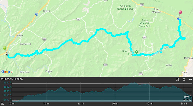
Appalachian Trail: Erwin, TN To Mountain Harbor Hostel
UPDATED 10-18-2020
 |
| The dense spruce forest. |
The climb out of Erwin was difficult but not terrible. I met a newbie after the first shelter. She'd started in Erwin and was hoping to meet up on the trail with her thru-hiker nephew. I don't think she will be on the trail for long. She needed help putting up her tent. All of her food was in the form of nutrition shake powder. No 'real’ food. Other people who saw her said she was struggling.
At a pass where the AT crossed a road I met Brother Tom handing out Trail Magic. I had lemonade, banana bread, and a brownie. He had been doing this for years. He commented how slow it was due to trail days. I didn't expect magic this late. Most 'professional' trail magicians travel with the March/April bubbles.
I arrived at my target campsite. I sat down and drank some water. I decided to push on. The added miles would not shorten my AT but it would allow me to stop at a famous shelter located in a converted barn.
The next four miles were pretty awful. I climbed up a steep mountain which had a dense spruce forest on the top. At one campsite partway up I noticed a tree decorated with Christmas ornaments. A note book explained that it was a memorial for a young man of twenty-two. At the bottom of the notebook cover was the suicide prevention hotline number. I left a message in the book but failed to take down the information.
The trail snaked through the dense spruce forest. The trail was somewhat vague so I walked from one white blaze to the next.
The trail down the mountain was difficult and my cranky left foot was having none of it. By the time I got to the Cherry Gap Shelter my foot was hurting and I was pooped. I did 17.1 miles (27.5 km).
I arrived to the shelter after 5:00pm and I was the only one there. Two others arrived over the next hour or so. Three people in a shelter area is rare. I ate, hung my food bag, and went to bed early. I dreamt I lost all my stuff while on vacation. It rained early in the morning and I was glad I'd skipped the campsite and moved on to the shelter.
 |
| Another day … Another view. |
Day 46 - This was a long day but satisfying. The up was tough and the down was welcome.
I passed the site of an old hotel that was dismantled a long time ago. I took a break at the highest shelter on the AT, Roan High Knob shelter. The shelter is actually a cabin with a door but it also had some Blair Witch vibes too. Apparently from the log notes the shelter is really cold at night.
 |
| The attic of the Roan High Knob Shelter. A bit spooky. |
Talked to Betty who was thinking about thru-hiking. I gave her advice and told her how it was on the trail. I hope she got something from my experience.
 |
| The view from my tent site. |
 |
| Near the top of Hump mountain. |
As I left the highlands I finally crossed into Tennessee. For a while the AT had bounced between Tennessee and North Carolina.
 |
| Another state bites the dust. |
I got a bed, took a shower, washed some clothes, and ate a pint of Ben and Jerry's. I resupplied at their well stocked general store and had a burger, fries, and a salad for dinner.
At the end of the day vans rolled in bring hikers who had jumped ahead for Damascus Trail Days. The trails will not be so empty tomorrow.
It will be a late start tomorrow as the all you can eat breakfast starts at 8:00am.
It will be a late start tomorrow as the all you can eat breakfast starts at 8:00am.
Pictures can be found in my 2019 Appalachian Trail Google Photos album.
Total Distance: 395.2 Miles (571.58 km)
Section Distance: 69.0 Miles (111.0 km)
Section Elevation Up: 14,697 ft (4,480 m)
Section Elevation Down: 16,998 ft (5,181 m)
|

Thursday, May 16, 2019
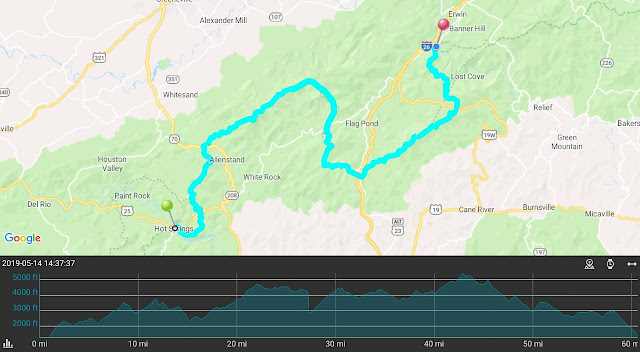
Appalachian Trail: Hot Springs, NC To Erwin, TN
UPDATED 10-18-2020
Day 37 - I left Hot Springs late because I'd forgotten to buy a gas canister for my stove. The outfitter opened at 9:00am and they were out of small cannisters so I bought a huge, heavy one.
 |
| The French Broad River along the trail. |
 |
| A bench begging to be sat on next to the serene pond. |
The full pack of food and bigger gas canister didn't help - by the time I got to the Spring Mountain Shelter I was exhausted. By the the numbers the climb up to this shelter was not as bad as the first day in the Smokies but I was more tired and worn out today. This was a bit demoralizing. I felt I was backsliding. It was supposed to be getting easier.
Day 38 - My plan for the day was to do a short hike to the next shelter some 8.6 miles (13.8 km) away. When I got there I felt like I'd gone through the wringer. I was pooped.
I stopped at the shelter and rested. Drank some water and ate some food. Then I made an odd decision. I decided to hike the 7.3 miles (11.7 km) to the next shelter.
 |
| Note the AT blazes going down the rock wall. I climbed down the wall hand over hand. |
 |
| Passed the three hundred mile mark. |
There were several people at the shelter including an Italian named Long Feather (for the feather in his hat) who played the guitar.
Day 39 - The forecast had rain Saturday and Sunday. Some people in the shelter were going to hunker down. This didn't make sense to me so I started out in the drizzle.
There was only one hill in my way, Big Butt Mountain (love how things are named in these parts). It was just a light intermittent drizzle when I crossed the crusty rocky top of big butt. After the summit it started to rain harder.
I started humming songs with the word 'sunshine' in their title. It worked. My mood was lifted up and I really made good time down the hill. The good mood was countered by an older hiker wearing a Trump 2020 hat who liked to preach to the younger generation. I did my best to politely ignore him.
At the bottom I made my way to the Laurel Hostel. This place is tiny and has few amenities but it was dry and warm and the shower was hot. The resupply was non-existent so the owner took me and a few other hikers to Erwin, TN for resupply and McDonald's take out.
Day 39 - The forecast had rain Saturday and Sunday. Some people in the shelter were going to hunker down. This didn't make sense to me so I started out in the drizzle.
 |
| Is this Big Butt Mountain's crack? |
I started humming songs with the word 'sunshine' in their title. It worked. My mood was lifted up and I really made good time down the hill. The good mood was countered by an older hiker wearing a Trump 2020 hat who liked to preach to the younger generation. I did my best to politely ignore him.
At the bottom I made my way to the Laurel Hostel. This place is tiny and has few amenities but it was dry and warm and the shower was hot. The resupply was non-existent so the owner took me and a few other hikers to Erwin, TN for resupply and McDonald's take out.
While I was heading north we heard stories of a murder on the AT. Turns out the murderer stopped at the Laurel Hostel briefly. The owner pointed out a hole made by a knife point. Apparently the guy known as Sovereign stabbed his knife into the top of the coffee can tip can. The owner then told him to leave (no doubt backed by the second amendment). Soon afterward the guy killed a hiker and almost killed another.
Day 40 - The forecast for today was more rain so a few of us decided to take a zero in the hostel. We went into town again to eat and get more supplies. This was the third weather related zero day and I wondered if I'm being too cautious. Hiking in the rain can suck but as they say "you must embrace the suck." This zero day ate up my extra day I'd earned a few days ago. In hindsight I should have not taken the zero day at the hostel. It really didn't rain that much the next day. The confederate flag under one of the bunks didn't make me comfortable either.
 |
| This appears to be a bear print on the trail but no bear has been seen yet. |
The owner of the hostel was nice enough. His older brother would show up every now and then. His accent was so thick I could hardly understand him. A hiker from Netherlands was fascinated by him since he had no clue what he was saying. He just kept nodding his head.
This day also tied for the longest hike in terms of days hiked I've ever done matching my second Camino.
Day 41 - After talking with other hikers over the past couple of days I decided to push hard the next couple of days. This day would be a long 15.9 miles (25.6 km) predominantly up hill.
It was a very long day and it was overcast and a bit uninspiring but after seeing some interesting but muted views from Big Bald Mountain I arrived at Big Bald Mountain Shelter where I spent the night with a few other hikers.
Day 42 - Temperatures were in the low 40s this morning and for some reason I was really cold. I think some of my insulating fat layers have been replaced with non-insulating muscle. I spent most of the night putting on more layers.
I left early and hiked hard in an attempt to warm up. Today I would push hard again, this time predominantly down. By the end of the day I'd hiked 16.8 miles (27 km) to Uncle Johnny's Nolichucky Hostel and Cabins just outside Erwin, TN.
I rented a cabin that had a set of bunk beds with full size mattresses. I've never seen that large of a bed. The hostel has an outfitter and offered three free shuttle trips into Erwin. I took one of those shuttles into town to resupply and eat an Italian dinner.
This day also tied for the longest hike in terms of days hiked I've ever done matching my second Camino.
 |
| A meadow is a nice change of scenery along the trail. |
It was a very long day and it was overcast and a bit uninspiring but after seeing some interesting but muted views from Big Bald Mountain I arrived at Big Bald Mountain Shelter where I spent the night with a few other hikers.
 |
| Is that Pi or is a shelter nearby? |
 |
| Lots of rain equals lots of water in the streams. |
I rented a cabin that had a set of bunk beds with full size mattresses. I've never seen that large of a bed. The hostel has an outfitter and offered three free shuttle trips into Erwin. I took one of those shuttles into town to resupply and eat an Italian dinner.
I spent time with a few hikers I knew including Eastwood and Jim (He always wore a bandana but too many hikers were named Bandana). Jim and I had spent the last few shelters and the Hostel together.
The hard hiking days I'd just done had pushed me a day ahead of schedule.
Day 43 - Another zero day to recover from the two hard days I'd just hiked. A shuttle into town for breakfast and a relaxing afternoon at the hostel to let my body recover. That was what I needed.
A lot of hikers here were shuttling ahead to Damascus to celebrate Trail Days. It's a big celebration with gear vendors, food, and lots of drinking. I decided to skip it. Who knows, I may catch up to people who took time off for the festivities. I expect the trails to be empty between Erwin and Damascus. Eastwood and Jim took the shuttle. I never saw them again.
Pictures can be found in my 2019 Appalachian Trail Google Photos album.
Total Distance: 355.16 Miles (571.58 km)
Section Distance: 70.35 Miles (113.22 km)
Section Elevation Up: 15,928 ft (4,855 m)
Section Elevation Down: 15,794 ft (4,814 m)
|

NOTE:. Due to human error, part of the GPS track was not recorded properly. I drew in the approximate route on the map but the elevation data listed above is an approximation.
Wednesday, May 15, 2019
My Eighth Caminoversary
We often do not realize that our lives are a series of life changing adventures.
Enjoy your life and onward to your next adventure ...
 |
| Follow your own Camino. |
Sunday, May 12, 2019
Happy Mother's Day
I want to wish my Mom a very Happy Mother's Day.
I would be nothing without you.
I would have liked to be there but the trail calls.
I would be nothing without you.
I would have liked to be there but the trail calls.
Thursday, May 09, 2019
Appalachian Trail: Standing Bear Farm Hostel To Hot Springs, NC
UPDATED 10-18-2020
My first bubble is way ahead of me. I liked most of those people. Only Curry, who has had knee issues, is behind me. My second bubble didn't click with me. My third had some good people who I liked but they too are ahead of me. The latest one was, frankly, too old. I prefer a younger group who doesn't discuss retirement or losses in their families. Younger people are more positive and supportive.
I have been told there are a few bubbles behind me. Not sure if they will catch up with me. If they do, will we find something in common?
 |
| An orange salamander sharing the wet trail. |
I climb up the trail in pouring rain. I'd thought I might do a fifteen mile day but the river that was the trail, and my wet cold self, convinced me to go for my planned stop of 6.9 miles (11.1 km).
I arrived early to the shelter and stripped off my wet clothes and put on some dry things to help me warm up. The weather got better but I decided to stay anyway. In hindsight this was a mistake. Several other hikers stopped at the shelter with me but continued on once the rain had stopped. I should have done the same, maybe not another six miles but anything more would have been better in the long run.
Day 34 - This morning started out cloudy but dry. The trail was still slow going due to the muddy swampy conditions left by the rain. I started out really slow this day.
 |
| The view from Max Patch. |
After Max Patch I got a second wind and finished the 13.1 mile (21.1 km) target for the day. The shelter was small and a bit rundown so I tented for the fourth time on the AT. A couple older gentlemen stopper here as well.
 |
| For my Mom: Closest thing to a Maiden Hair Fern that I could find. |
 |
| The AT symbol marking the trail in Hot Springs. |
I checked out the town and got some food - not easy to do when three of the four restaurants were closed for one reason or another. I did eat a pint of Ben and Jerry's while I did laundry.
On the second day I slept in a little and had a good breakfast. I ran into Strider, Hemingway, and Cricket here where they were taking a longer break.
I resupplied at the outfitter, Dollar General, and a cool country store. Since I was in a town named Hot Springs I soaked in a mineral springs hot tub. I was alone since most of the hikers I knew in town had soaked the day before. I bought a sleeve for my cranky left foot. Just a bunch of town and trail related stuff.
Today, after this posts, I will return to the trail. It is tough leaving the comfort of the town. At times it seems all I think about when on the trail is getting to the next town. I can't say this is the right attitude and it may just be a passing phase but it has been tough at times to keep positive. To be honest, while I'm in town all I think about is getting back on the trail.
A comment about statistics. 25% of thru-hikers quit by Neel Gap (day four for me). 45 to 50% have quit by Hot Springs. The odds are getting better that I'll make it all the way. Barring an unexpected injury, the only thing in my way is my mental state. The past few days have been tough for me. All I can say is I am here to finish and I will keep on keeping on.
Pictures can be found in my 2019 Appalachian Trail Google Photos album.

NOTE: I have corrected a day numbering issue in the last few posts.
Today, after this posts, I will return to the trail. It is tough leaving the comfort of the town. At times it seems all I think about when on the trail is getting to the next town. I can't say this is the right attitude and it may just be a passing phase but it has been tough at times to keep positive. To be honest, while I'm in town all I think about is getting back on the trail.
A comment about statistics. 25% of thru-hikers quit by Neel Gap (day four for me). 45 to 50% have quit by Hot Springs. The odds are getting better that I'll make it all the way. Barring an unexpected injury, the only thing in my way is my mental state. The past few days have been tough for me. All I can say is I am here to finish and I will keep on keeping on.
Pictures can be found in my 2019 Appalachian Trail Google Photos album.
Total Distance: 284.81 Miles (458.36 km)
Section Distance: 34.56 Miles (55.62 km)
Section Elevation Up: 8,105 ft (2,470 m)
Section Elevation Down: 8,721 ft (2,658 m)
|

NOTE: I have corrected a day numbering issue in the last few posts.
Sunday, May 05, 2019
Appalachian Trail: Gatlinburg, TN To Standing Bear Farm Hostel
UPDATED 10-18-2020
Day 30 - Hitchhiking didn't happen. After another thru-hiker and I tried and failed to get anyone to stop we decided to share a Lyft to Newfound Gap.
 |
| Charlie's Bunion. |
Met Mama Peaches and her daughter Woodstock (Months later I would meet them again after they flip flopped) and a few section hikers.
Day 31 - I decided to do another long day. This time it was 13.2 miles (21.2 km). It drizzled on and off though I still saw some awesome views.
 |
| A view before the rain. |
A Ridgerunner and his supervisor spent the night with us in the shelter as the rain started coming down.
Day 32 - A month on the trail. People got up early today. This gave me the opportunity to see my first sunrise on the trail. The best view of the sunrise was from the Privy.
I left the Smokies today on a long downhill hike. This was another rule of the park, you had to get through the park in eight days or less. At one time I didn't think I would make it but it turned out not to be a problem as I hiked out on day eight.
The weather started out great but turned humid as the day went on and the rain returned.
Part of the trail passed a river and the sound of water was soothing. The ground was wet from the rain and going downhill was slow and a bit slickery.
The trail crosses over the first major river (the Pigeon River) before going under I40. There was some trail magic under the bridge. From there it was a short, humid hike to Standing Bear Farm Hostel where I spent the night, ate some good food, took a hot shower, and did some resupply. An interesting place in the middle of nowhere. This hostel would close down due to a norovirus outbreak. The fact the cook didn't wear gloves and the kitchen wasn't far from the privy should have been a warning sign. Fortunately I didn't get sick.
Pictures can be found in my 2019 Appalachian Trail Google Photos album.

 |
| My first sunrise on the AT. |
 |
| A cluster of butterflies. |
Pictures can be found in my 2019 Appalachian Trail Google Photos album.
Total Distance: 250.26 Miles (402.75 km)
Section Distance: 35.39 Miles (56.95 km)
Section Elevation Up: 6,460 ft (1,969 m)
Section Elevation Down: 9,497 ft (2,895 m)
|

Saturday, May 04, 2019
May The Fourth Be With You
May the Fourth be with the Wife's niece and her brand new hubby.
Wishing them the bestest of wedding days and a wonderful life together.
Wish I was there to celebrate with you guys but the trail calls.
Wishing them the bestest of wedding days and a wonderful life together.
Wish I was there to celebrate with you guys but the trail calls.
Thursday, May 02, 2019
Appalachian Trail: Fontana Dam To Gatlinburg, TN
UPDATED 10-18-2020
 |
| The view from the Fontana Hilton. |
On this zero day I met Mary Poppins (a guy who knows how to properly pack pop tarts), Super, My Way, Bob (a German girl - she liked the sound of the name), Barefoot, Lunger, Strider, Hemingway, Cricket, and others.
An older lady was parked at the parking lot up the trail from the shelter. She had bins full of food and toiletries. Her grandson (I think) was hiking the AT and she was driving along the way giving out trail magic. She said she'd watched a lot of videos on YouTube to figure out what hikers needed. I helped her pack up her SUV and then she joined the hikers down by the shelter and enjoyed talking, drinking, and partaking of a joint or two.
Day 25 - I'd been dreading this day for some reason. The Smokies were notorious among AT thru-hikers for being difficult. I left the Fontana Hilton, along one of the few paved sections going to the Dam visitors center, over the dam itself, and into the Great Smoky Mountains National Park.
My original plan was to do the Fontana Dam to Gatlinburg section in four days. In Franklin I decided it was too aggressive of a plan so I made it five days. This new plan died when I arrived at my first stop at 10:40am. I still felt pretty good so I made for my old goal. Mollies Ridge Shelter was 11.8 miles (19.0 km) with over 4,000 ft (1219 m) gain in elevation. I felt oddly refreshed when I arrived.
All the shelters in the Smokies are made of stone and have fireplaces.
I was joined by most of my new trail family here as well as Ridgerunner David who helps maintain the shelters and trail. Ridgerunner David laid out all the rules such as you have to stay in a shelter in the Smokies. He was a nice guy but some didn't appreciate there being 'law' on the AT.
Day 25 - I'd been dreading this day for some reason. The Smokies were notorious among AT thru-hikers for being difficult. I left the Fontana Hilton, along one of the few paved sections going to the Dam visitors center, over the dam itself, and into the Great Smoky Mountains National Park.
 |
| Beautiful reflections. |
All the shelters in the Smokies are made of stone and have fireplaces.
I was joined by most of my new trail family here as well as Ridgerunner David who helps maintain the shelters and trail. Ridgerunner David laid out all the rules such as you have to stay in a shelter in the Smokies. He was a nice guy but some didn't appreciate there being 'law' on the AT.
One of those laws what that everyone except AT Thru-hikers needed reservations to stay in the shelter and, if it was full, thru-hikers had to give up their spaces in the shelter. I was mildly worried about this but never was kicked out of a shelter.
Day 26 - Having been a bit overconfident after the prior day's hike I decided to push again and make for Derrick Knob Shelter. Ridgerunner David had implied that it would be easier than the previous day. Shame on you Ridgerunner David. You fibbed.
When I arrived at Derrick Knob Shelter I'd hike a brutal 12.1 miles (19.5 km) up some pretty steep hills. The only consolation was that everyone in my trail family felt the same way about this section. I went to bed at 6:30pm but didn't fall asleep until my legs finally stopped aching.
Day 27 - I had a decision to make. It was a gorgeous day weather wise and I really wanted to reach Clingmans Dome, the highest point on the AT. To do this I would have to climb over three thousand feet and hike 14.1 miles (22.7 km). The other choice was to stop three miles short and do it the next day when the weather might not be as good. I decided to play it by ear.
When I reached the shelter before the final push to Clingmans Dome I stopped and took a rest. I felt surprisingly good. I decided to move on. I reached the peak of Clingmans Dome and celebrated not only reaching the highest point on the AT but it turns out that the peak is also at the 200 mile (322 km) point - another milestone.
While at the top a lady gave us brownies and cookies while her husband gave Six (a new hiker for my collection) a back stretch. Another family with a sweet little girl shared her candy with us. A nice trail magic surprise.
I left because I still had four miles to go. On the way down I kept hearing sirens. Turns out a person suffered an heart attack at Clingmans Dome. One of the thru-hikers I knew, Godspeed, had administered CPR until the EMTs arrived.
I arrived at the Mt Collins Shelter feeling pretty good. No major aches or pains though I had been taking ibuprofen (vitamin I) due to a mildly cranky left foot. Despite feeling pretty good I still went to bed early. Going to bed early was a bad habit that I developed on the AT. In hindsight I should have tried to stay up longer to socialize more.
Days 28 & 29 - I hiked the short 4.6 miles (7.4 km) to Newfound Gap and tried to figure out how to get to Gatlinburg. Most of my impromptu second trail family did not stop here so I was alone again. I noticed a thru-hiker named Letters that I met briefly getting back on trail. Her friend who was dropping her off offered me a ride into town.
Day 26 - Having been a bit overconfident after the prior day's hike I decided to push again and make for Derrick Knob Shelter. Ridgerunner David had implied that it would be easier than the previous day. Shame on you Ridgerunner David. You fibbed.
 |
| A great view after a difficult climb. |
Day 27 - I had a decision to make. It was a gorgeous day weather wise and I really wanted to reach Clingmans Dome, the highest point on the AT. To do this I would have to climb over three thousand feet and hike 14.1 miles (22.7 km). The other choice was to stop three miles short and do it the next day when the weather might not be as good. I decided to play it by ear.
 |
| The observation tower at the top of Clingmans Dome. |
While at the top a lady gave us brownies and cookies while her husband gave Six (a new hiker for my collection) a back stretch. Another family with a sweet little girl shared her candy with us. A nice trail magic surprise.
I left because I still had four miles to go. On the way down I kept hearing sirens. Turns out a person suffered an heart attack at Clingmans Dome. One of the thru-hikers I knew, Godspeed, had administered CPR until the EMTs arrived.
I arrived at the Mt Collins Shelter feeling pretty good. No major aches or pains though I had been taking ibuprofen (vitamin I) due to a mildly cranky left foot. Despite feeling pretty good I still went to bed early. Going to bed early was a bad habit that I developed on the AT. In hindsight I should have tried to stay up longer to socialize more.
Days 28 & 29 - I hiked the short 4.6 miles (7.4 km) to Newfound Gap and tried to figure out how to get to Gatlinburg. Most of my impromptu second trail family did not stop here so I was alone again. I noticed a thru-hiker named Letters that I met briefly getting back on trail. Her friend who was dropping her off offered me a ride into town.
 |
| Follow the old wooden path. |
She dropped me off at the NOC satellite store where I found a nearby hotel and got checked in. I navigated the trolley system in this tourist trap of a town to get to the post office to pick up my new rain fly and to mail the damaged one back to the manufacturer. The rest of the day was doing a partial resupply for when I reenter the Smokies and exploring the Old-Time Photograph capital of the world not to mention marveling at the multiple Ripley's Believe It or Not attractions just on the main drag. This place is hard to believe … or not.
I had a high priced … and disappointing steak here.
On my second day in town I once again navigated the trolley systems of both Gatlinburg and Pigeon Forge so I could see the new Avengers movie. Most of the navigating consisted of waiting. I waited way too much today. The movie was worth it.
After the movie and waiting I finished my resupply, got some food in my belly, and made preparations for getting back on the AT. Not sure how I will be getting back to Newfound Gap. The church sponsored shuttle services had literally been discontinued the day I arrived. This may be my first hitchhiking experience. I wonder if the rain in the forecast will help or hinder my first attempt.
Pictures can be found in my 2019 Appalachian Trail Google Photos album.
Total Distance: 214.87 Miles (345.80 km)
Section Distance: 43.27 Miles (69.64 km)
Section Elevation Up: 12,143 ft (3,701 m)
Section Elevation Down: 9,466 ft (2,885 m)
|

Subscribe to:
Posts (Atom)