UPDATED 10-18-2020
Day 1 - Mama's Taxi dropped me off at the Springer Mountain parking lot on Wednesday morning. Mountain Squid, a trail volunteer, was taking people's names and handing out trail magic. |
| The first white blaze and plaque on the AT at the summit of Springer Mountain. |
The weather was gorgeous and the trail was mostly downhill until I arrived at my stop for the night, Hawk Mountain shelter.
I met a few thru-hikers here that I would see along the way.
NOTE: I will use trail names when I can even though some of the names were bestowed after I actually met them.
Here I met Cloud and his dog Raindrop, No Heart (Yeah ... he was often heartless), Nightingale (caught singing in his tent), Crow, Curry (made curry her first night that was so spicy she couldn't eat it), Snowman, Kilroy, and Waka-Waka (he stuttered and had difficulty saying his home town ... and he like Fozzie Bear).
Day 2 - It turns out that I am the early riser of the group. I just can't sit around in the morning when there's hiking to do. Like day one the weather was great. I made good time.
 |
| An AT critter crossing my path. The largest thing I've seen so far is a squirrel. |
That night the rain came and I was glad to be in a shelter.
Day 3 - On day three it was a bit dreary and wet after the night's rain. I passed a huge puddle. It turns out several people including Waka-Waka, Kilroy, and Snowman had set up their tents where this puddle was and had been flooded out overnight.
Near the end of my hiking day I caught up with Curry and walked with her for a while. Along the way she christened me Little Hill because of the little hills I trained on near my home in Nebraska. We met up with Two Sticks (later rechristened Pack Flip - he put his pack on by flipping it over his head). She was going to hike a long day up and over Blood Mountain. I seriously considered going with her but, when we stopped at my original goal for the day I reconsidered and decided to stick to my original plan and camp at Lance Creek. Looking back this was the right decision for me. Curry and Pack Flip moved on.
Met Cowboy, Josh, and Ryan along the way. Poor Josh lost his tent poles so had to put his tent up with literally sticks and cord. Fortunately for him it didn't rain this night.
This was the first time I'd ever put up my tent on this AT attempt.
Day 4 - It was another foggy, overcast day as I climbed up and over the ominously named Blood Mountain, the highest peak on the AT in Georgia. Because of this there were no views this time and fewer people up top. Climbing the mountain wasn't nearly as tough as I remembered it but going down was just as hard, if not harder, than I remember.
I stopped at Neel Gap and Mountain Crossings outfitters. I restocked my food and spent the night in the hostel. Curry was still here. The long day had did her in and she had reinjured an old knee injury but she continued on later in the day to a campsite four miles or so farther along. The only person I knew in the hostel was cowboy. A bunch of others went down to Blood Mountain cabins for the night.
I met Shark Chow here. He is an ocean kayaker and a journalist.
Day 5 - This was the longest day on the AT so far. It was nearly eleven and a half miles with a crap ton of ups and downs. When I arrived at Low Gap shelter I was pooped. Crow was here along with Llama Mama. The whole family showed up here soon afterwards.
Along with Llama Mama I met Hershey Legs, Eagle with his dog Camo, AKA, and a strange one named Nemo.
Day 6 - the last whole day on the trail before my first break was a relatively easy one to Blue Mountain shelter. It rained on and off this day and my rain coat got a workout.
It was chilly on the top of Blue Mountain and people were showing up soaked. Crow, No Heart, Curry, and Tortoise (I described her as only a section hiker and she took offense - oops) all tried to warm up a shivering Llama Mama. We managed to get her out of her wet clothes into dry ones and Crow filled a bottle with hot water to use as a hot water bottle.
This was, by far, the wettest day so far. Everything felt damp and wouldn't dry.
Days 7 & 8 - I left the shelter early at 7:30am and headed down Blue Mountain. It wasn't raining as I'd expected it would be which made the wait for the shuttle at the bottom better.
Laundry, lunch, shower - these were the main tasks for the day. I also wrestled with editing pictures and downloading track file from my GPS. My file renaming and photo editing apps, which are great on my Chromebook at home, did not work properly on my tablet. My GPS, which has worked great so far, stopped talking to my tablet. I spent a few hours fighting with things that should have taken me less than an hour to complete. *Sigh*
Today I'm trying to stay off my feet, which is turning out to be hard since I have to walk around town to resupply and get food to eat. I resupplied at the local grocery store. I only need two days since I will be resupplying at the Top of Georgia hostel/outfitter.
To my surprise Crow and Curry showed up at my hotel on day eight. They pushed hard and got off at Dick's Creek Gap and came into town. This made the last evening of my zero day fun. We all went to the all you can eat Daniel's Steakhouse (My third visit there).
Tomorrow I get shuttled back to the trail and head back out. Weather is supposed to be good the first day but rain returns.
This is a fairly long post but I haven't even tried to tell all the stories behind all the trail names or all the other stories heard along the AT. If I did the post would never come to an end - and this is after only one week.
Pictures can be found in my 2019 Appalachian Trail Google Photos album.
NOTE: This will be the last cool map and graph until I figure out what's wrong with either the GPS or the cable.
 |
| A, so far, typical foggy day on the AT. |
This was the first time I'd ever put up my tent on this AT attempt.
Day 4 - It was another foggy, overcast day as I climbed up and over the ominously named Blood Mountain, the highest peak on the AT in Georgia. Because of this there were no views this time and fewer people up top. Climbing the mountain wasn't nearly as tough as I remembered it but going down was just as hard, if not harder, than I remember.
 |
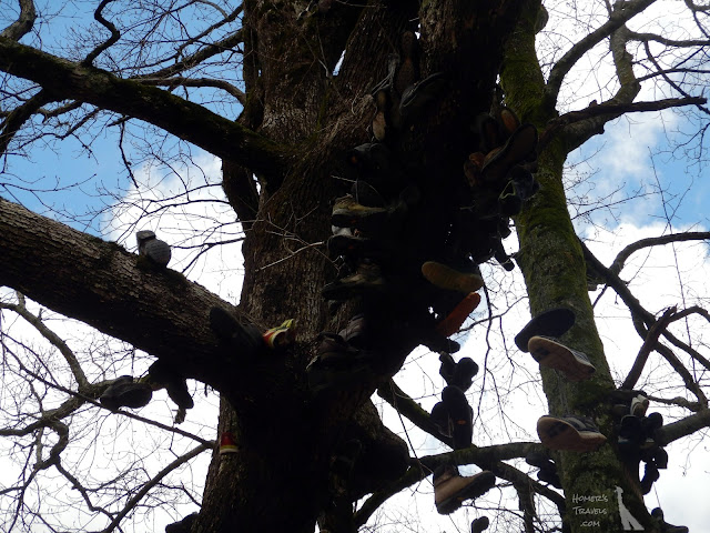
| The Neel Gap shoe tree where quitters surrender their shoes. |
I met Shark Chow here. He is an ocean kayaker and a journalist.
Day 5 - This was the longest day on the AT so far. It was nearly eleven and a half miles with a crap ton of ups and downs. When I arrived at Low Gap shelter I was pooped. Crow was here along with Llama Mama. The whole family showed up here soon afterwards.
 |
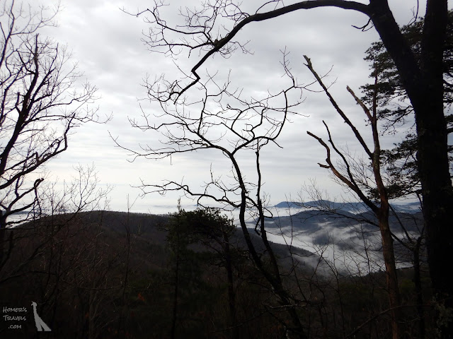
| Some views today before the fog and clouds came rolling back in. |
Day 6 - the last whole day on the trail before my first break was a relatively easy one to Blue Mountain shelter. It rained on and off this day and my rain coat got a workout.
 |
| Just love the stacked stone. |
This was, by far, the wettest day so far. Everything felt damp and wouldn't dry.
Days 7 & 8 - I left the shelter early at 7:30am and headed down Blue Mountain. It wasn't raining as I'd expected it would be which made the wait for the shuttle at the bottom better.
Laundry, lunch, shower - these were the main tasks for the day. I also wrestled with editing pictures and downloading track file from my GPS. My file renaming and photo editing apps, which are great on my Chromebook at home, did not work properly on my tablet. My GPS, which has worked great so far, stopped talking to my tablet. I spent a few hours fighting with things that should have taken me less than an hour to complete. *Sigh*
Today I'm trying to stay off my feet, which is turning out to be hard since I have to walk around town to resupply and get food to eat. I resupplied at the local grocery store. I only need two days since I will be resupplying at the Top of Georgia hostel/outfitter.
To my surprise Crow and Curry showed up at my hotel on day eight. They pushed hard and got off at Dick's Creek Gap and came into town. This made the last evening of my zero day fun. We all went to the all you can eat Daniel's Steakhouse (My third visit there).
Tomorrow I get shuttled back to the trail and head back out. Weather is supposed to be good the first day but rain returns.
This is a fairly long post but I haven't even tried to tell all the stories behind all the trail names or all the other stories heard along the AT. If I did the post would never come to an end - and this is after only one week.
Pictures can be found in my 2019 Appalachian Trail Google Photos album.
Section Distance: 55.47 Miles (89.27 km)
Section Elevation Up: 10,983 ft (3,348 m)
Section Elevation Down: 12,395 ft (3,778 m)
|
 |
| The map for my first section of the Appalachian Trail from Springer Mountain to Unicoi Gap (Hiawassee, GA). |
No comments:
Post a Comment