Homer's Travels: Geocaching
Showing posts with label Geocaching. Show all posts

Sunday, October 17, 2021

A Round About Way To A Similar Destination

 A couple things reached the same destination this year.  Both took different routes … both had different reasons … but both got to the same place.

The first started as a pandemic lockdown project for the Wife.  Over the past year or so the Wife has pursued a dual citizenship.  The first is American, naturally, and the other is through genealogy.  The Wife has ancestors from Luxembourg and for the past year she has collected birth certificates, wedding records, death records, and other genealogical proof of her Luxembourgian ancestry.  She had filled out requests and forms, often multiple times, and submitted her application for Luxembourgian citizenship.  She reached her goal in August when she was granted citizenship.

A blurry picture of the original
Walking Sister travel bug.
The second has been talked about before in Homer's Travels.  In 2007 I sent out a geocaching travel bug called the Walking Sister.  It travelled around the United States for almost four years before it turned up missing.  I had a duplicate of the travel bug tag so I made a new Walking Sister.  This time I dropped her off in Santiago de Compostela, Spain on my first Camino.  It was soon picked up and started travelling around Europe.  Starting from Spain it went to Portugal, France, Germany, the Netherlands, Belgium and even took a side trip to Cyprus.  Combined the two versions of the Walking Sister have visited one thousand six hundred and eighty two geocaches and have travelled 40,189.9 miles (64679.2 km).

So how are these two things connected?  Last week I received an update.  The Walking Sister's latest stop is in … Luxembourg.

Monday, January 09, 2012

Route 66 & California - Topa Topa Ridge

On our second day in Oxnard-Ventura area I did a hike.  When I was planning this trip I'd narrowed my hiking choices down to two: Potrero John or Topa Topa Ridge.  Potrero John is a relatively flat five miler while Topa Topa is a 15+ miles with 5,000 foot of elevation.  I figured I would decide after talking to GeekHiker.

As I discovered, and mentioned in my last Route 66 & California post, GeekHiker was not available so the choice of hikes was up to me.  I ended up choosing Topa Topa.

Now let's look at the rational for doing this hike, the hardest one day hike I'd ever done.  I'd just finished walking 510+ miles on the Camino.  I'd crossed the freakin' Pyrenees mountains with a pack on my back.  The Topa Topa hike wasn't very much different from the first day on the Camino.  On top of that, I'd already done this hike and I didn't remember it being too hard, - difficult yes, too hard no.  I felt like a superman, baby!  Bring it!  Heck, I figured it would be so easy I could do Potrero John the next day.  Yeah ... right.

Flowers on the way up Topa Topa Ridge.
So I drove up to the trailhead.  There are a couple parking spots one at the trailhead itself and another about a half mile down the dirt road.  The last time I was there they had just done maintenance on the road and you could take a regular car to the trailhead.  Apparently they haven't maintained it since I left California because there were ruts in the road big enough to swallow up the Honda Civic I was driving.  I ended up parking in the parking area about a half  mile from the actual trailhead.  PFFT!  a half mile is nothing.

I didn't have a pack.  I had a camelback full of water and a few snack bars in my pant's pockets.  I was back in my pilgrim garb (The first time in boots, long pants, and hat since I returned from Spain).  I had my hiking pole.  I confidently started up the trail.

The trail up to Topa Topa ridge.
It was mid-July and usually it can get quite hot but the weather this day was overcast and in the 70s.  The last time I did this hike it had also been cloudy and I wasn't able to get a clear picture of Topa Topa ridge.  Apparently Topa Topa is shy and she kept herself hidden from me once again.

I felt pretty good until I didn't, which is usually the case.  After the White Ledge Campground, following the arrow (white ... not yellow) the trails turns steep and the energy just drained out of me.  Several times as I plodded up that hill I asked myself "what was I thinking?"  My walking speed declined steadily.  I berated myself all the way up to the top to Nordhoff Ridge road.  I almost turned around twice.

I knew there was a picnic table just up the road and I figured I could rest there.  I turned a corner and there were a couple trucks and several people camping by the picnic table.  The table was full of stuff and I decided that I would just keep going.  One of the guys said hi and asked if I was okay.  I said yeah.  He said "You don't look it."  I should have taken that as a hint and quit there but I didn't.  I'd just walked across northern Spain Damn it!!

The sign says it all.
I reached the trail that took you to the top of Topa Topa ridge aptly named Last Chance trail.  At this point the trail really turns up and becomes a bit treacherous.  I stopped a lot on the way up this trail and when I finally reached the top I collapsed on a stone bench at the top.

I set the timer on my watch for thirty minutes and decided not to move until it went off.  I was wiped.  Totally wiped.  This was so much harder than the last time I did it.  It was harder than any day in Spain.  I guess sitting in the car for the last two weeks had erased any benefit I'd gained in Spain.  I was completely spent.  I had nothin'.

My alarm went off and I figured if I didn't get going I would never make it.  I took in the views - the ridge was above the clouds and the views were quire lovely - and headed back down the way I came. (I found a geocache on the way down ... the second one found without using my GPS on this trip - "Middle Switchback")

The view from Topa Topa Ridge.
Usually I find that going down is easier than going up.  At least it feels like it take less energy.  It is also hard on the knees.  By the time I made it down my legs and knees had taken some major punishment.  Even my walking stick hadn't helped much.  I cursed myself for not listening to my inner voice when I wanted to turn around.

The last mile or two ... or three or four ...  I was staggering.  I probably looked like an extra on the Walking Dead.  I was cursing myself all along the way down.  It didn't help that I'd run out of water three miles from the car.  This superman had met his kryptonite.  This hike was very humbling.  At the hotel I had the first ibuprofen since I'd returned from Spain.  Actually it might have been the only Ibuprofen I've had since I returned from Spain.  I also had three blisters on my feet, which were the least of my problems.

For the next five or six days my right knee hurt like heck.  I've learned since then, talking with my physical therapist, that the pain I felt was joint pain possibly caused by damage to the cartilage and/or meniscus.  My twisted pelvis, aggravated back injury, and my over-pronation probably conspired together to put extra stress on the right knee.  As of the writing of this post I still have issues with my right knee.  I've been wearing a sleeve on the knee when I walk which seems to help.

Oh ... and I didn't do Potrero John the next day.  Couldn't have done it if I wanted to.  Could hardly walk.

These pictures and more have been added to my 2008-2011 Topa Topa Ridge Hike Google Photos album.


Total Distance: 15.82 Miles (25.46 km)
Total Time: 8 Hours 31 Minutes
Total Elevation Up: 5,105 ft (1,556.00 m)
Total Elevation Down: 5,108 ft (1,556.92 m)

[Click on map for a larger version]
Note:  In the map, the bottom two plots show the elevation in red and the speed in the blue.  Each spike down is a rest stop.  That's why it took over eight hours to complete this hike.

Monday, December 19, 2011

Route 66 & California - Oklahoma, Texas, And New Mexico.

It was Sunday when we left Weatherford, OK.  We drove around looking for the space-suited statue of Thomas P. Stafford but, after finding the appropriate park, decided that the statue was not there anymore.

We got back on the route and, after a brief stop near Canute, OK to see a 1928 Grotto (Here I found a geocache without even using my GPS - it was just sitting on the ground next to the Grotto), we headed for Elk City.   In Elk City we visited the National Route 66 Museum ... that was closed.  It would open in a couple hours if we wanted to wait ... which we didn't.

The Route 66 museum sign.  The museum was closed.
The rest of western Oklahoma was pretty desolate.  We stopped at the Stardust Hotel & Restaurant in Sayres, OK for lunch.  This was our second choice but the Western Motel and Route 66 Bar was closed ... permanently.  Turns out the Stardust served a mean Sunday Buffet and I was quite satisfied with the meal.

The Route here follows I-40 most of the time.  You drive along frontage roads that parallel the highway.  Every few miles the frontage road would cross under or over the freeway and continue on the other side.  I wish I'd  counted the number of times we switched back and forth over the highway.  It turned into a joke after a while.  It was tempting just to get on the freeway but we wanted to stay as faithful to the route as possible so we tolerated the zig-zag path along the route.

We entered Texas.  The drab scenery and highway hopping that started in Oklahoma continued across the Texas panhandle.  We passed a bank whose sign said it was 110°F (43.3°C) outside.  I didn't believe it.   "That can't be right," I said. Not much farther ahead another sign said 109°F.  OK, I guess it was right.

We stopped in McLean, TX at the Devil's Rope/Old Route 66 Museum (Devil's Rope = Barbed Wire).  It was closed on Sunday.  Outside the museum in the little shade that existed we found three bikers (riding Harleys) and a fourth driving an SUV.  Turns out they were European tourists (a Brit, a Spaniard, and I don't remember where the other two were from).  They'd flown into Chicago, rented the SUV and motorcycles, and were riding Route 66.  The SUV was a good idea.  The bikes, in this heat .... well you could see it on their red, puffy, sweaty faces.  It was too hot for that.

Barbed Wire Balls
We said our goodbyes, got back in our air conditioned car, and continued West.  In Groom, TX we left the route to visit "the largest cross in the western hemisphere."  The 190 foot cross is impressive but it felt a little cheesy to me.  We followed the sign to the visitor's center (called a Pilgrim Center).  We used the facilities and walked through the gift shop.  I noticed something here.  While all the Route 66 guestbooks I'd seen until then had a lot of foreign tourists, the cross' guestbook had only Americans.  A little girl wondered aloud if Jesus was hurting while nailed to the cross.  I guess we were in the bible-belt.  On the way out to the car I walked by the life sized stations of the cross statues and reached a depiction of the last supper.  As I took a picture of Saint James, a little boy walked up to the Judas statue and gave it a hard slap saying that he was "bad."  His mom explained he had been punished enough.  I hurried back to the car.  Strange ... I'd felt more comfortable visiting the Mosque in Jordan than this cross in Texas.

190 feet tall cross near Groom, TX.
Next came Adrian, TX, the geographic midpoint of the Route.  There isn't much there so we stopped only to take pictures of the sign before moving on.

The midpoint of Route 66.
We ended our driving day in Tucumcari, NM.  The main street was lined with old hotels and stores with what looked like vintage neon signs.  You could tell the town was trying to keep the spirit of Route 66 alive.  That night we ate at the Pow Wow Restaurant & Lounge.  The Wife can testify that the hot sauce here is truly hot as her face turned red and her eyes and nose watered.

Being a Sunday we missed a few of the attractions and the scenery in the Texas panhandle ... well not the most interesting.  We'd been on the road now for five days and we were both a bit car weary.

These pictures and more have been added to my 2011-07 Route 66 Roadtrip Google Photos album.

Approximate distance driven this leg: 307 miles.

Thursday, November 03, 2011

Camino De Santiago - Cee To Fisterra

My last day of the Camino.  My last day of walking.  It felt a little surreal.  Today was day forty which I found a little ironic as I'd originally planned to do the Camino in forty days.  I just hadn't expected that would include a rest stop in Burgos, a day in Santiago de Compostela, and a walk to Fisterra.

I followed the arrows to the next town, Corcubión.  The markers took me to a church and then ... I lost the scent.  I assumed that they would take you back to the main road but, after walking along that main road for a while I realized I wasn't on the Camino anymore.  I looked at the map on my GPS and realized if I stayed on the road I was following I would eventually reach Fisterra.  I also guessed that the road I was on would eventually have to be crossed by the Camino.  It turns out I was right and, after a short distance of walking and worrying (I always fret about something), I reached an intersection of the Camino with the road and before you could say Buen Camino, I was on the Camino once again.  I celebrated by downing the chocolate bar I was carrying in my backpack.

The rest of the walk to Fisterra was gorgeous.  Forests.  Ocean views.  A nice village or two.  I climbed a hill and turned a corner and there it was in all its glory: Cape Fisterra.  The view wasn't perfect - the skies were overcast - but that did not diminish what I was feeling at that moment.  In a way it was more satisfying than reaching Santiago de Compostella.  It had a more final look to it.  You couldn't walk farther west if you wanted to.

My first view of Cabo Fisterra.
Faro Fisterra (Lighthouse Fisterra) can be made out of the tip of the cape on the left.
[Click on picture for a larger view]
The Camino took me down to a road, then detoured a bit as it headed down toward an isolated beach ... steeply .. before climbing ... steeply ... right back up to the road.  The Camino redeemed itself for this strange detour by following Langosteira Beach - a beautiful 1.2 miles (2 km) stretch of white sand.

The view of Langosteira Beech from Fisterra.  The clouds that were there earlier were long gone.
[Click on picture for a larger view.]
I entered Fisterra and followed the main road to the albergue.  It was way too early to check in, naturally.  I debated what to do for the three hours before it opened and decided to finish the walk once and for all.  I walked back up the street and followed the signs to Faro Fisterra (Fisterra Lighthouse).  The lighthouse was another 1.86 miles (3 km) up the road.

As I got closer I stopped to look for a geocache (Finis Terrae - Cache at the end of the world) on a side road within sight of the lighthouse.  It took me a while but I found it.  I'd carried four travel bugs with me and I dropped off a couple of them - Pilgrim's Companion and Hazard - Perry County Tour III Geocoin.  Both of them have since returned to the North America (the first is in Canada, the other in the United States).

I returned to the Camino and ran smack into the Canadian and his Japanese Girlfriend.  We talked as we approached the lighthouse.  The lighthouse was ... closed of course.  It's only open on Friday, Saturday, and Sunday.  It was Thursday.

I walked past the lighthouse and walked out to the farthest point of the cape.  There was clothes, boots, walking sticks, and other stuff all over the place.  As I mentioned before, the custom is that the pilgrim is supposed to burn or throw into the ocean, their worldly possessions.  I didn't have any matches or lighter but when I got out to the end I found some matches beside some clothes.  I pulled out my Columbia shirt and GV's sock.  I wondered how hard it would be to burn them since most clothes these days don't burn well, especially merino wool.  I looked around and realized that the brush on the cape was all burnt.  It was windy up there.  In my head I saw the headline: "Crazy American Pilgrim Sets Faro Fisterra Ablaze."  I thought about the festival later that night.  I was concerned that, if I was wrong about the festival, the clothes would never be destroyed.  I put rocks in the sock and the sleeves of my shirt.  I swung them around my head (the image of David slaying Goliath passed through my mind). With a mighty heave I threw them at the ocean ... and missed (the image of Goliath pounding David into the dirt passed through my mind).  Neither the sock or the shirt got even close to the water.  They just fell down the steep cliff side and were probably sitting on the rocks below.  *sigh*  Not exactly the end I was hoping for but it would have to do.

I asked the Canadian to take my picture beside the last marker (It's on Facebook).  The marker said 0.0 km.  This was the end on my road.  I headed back to Fisterra.  The Canadian and his Japanese Girlfriend convinced me to stay at the hotel they were staying at.  I'd passed it on the way up to the lighthouse.  I checked in and plopped down on the bed.  The toilet ran.  The place was a dump but it was cheap.

I did my chores and then headed to the albergue.  A sign on the lighthouse had said, if it was closed, you could get a lighthouse stamp at the albergue.  I stood in line, got my stamp, and was asked if I wanted a certificate.  I hadn't heard anything about certificates so I said sure.  She gave me a really cool certificate saying that I'd reached the Costa da Morte (Coast of Death - what they call this part of Spain) and had completed the Camino de Santiago.

I crossed the street to a German restaurant and ordered a plate of pasta and some ice cream for lunch.  It tasted good.  I wandered around the town.  There was a small beech where pilgrims were wading in the waves.  I took off my sandals and let the Atlantic ocean wash over my feet.  It felt like I'd made it.  As I left the beech an old pilgrim stripped down to his skivvies and went for a cleansing swim.

During my wanderings I ran into the Canadian and His Girlfriend again and I showed them my certificate.  They got excited and went to the albergue for their own certificates.  They were heading for the beech (the one I passed on the way in) and I tagged along.  We took the hard way over the rocks along the water.  I'm amazed I didn't hurt myself, especially since I was wearing sandals.

The beach was amazing.  At first I thought it was covered with stones but on closer inspection they were shells just like the pilgrim's shells.  Thousands of shells as far as the eye could see.  I picked up a few as a souvenirs.  The Canadian and his Japanese Girlfriend were having fun in the water.  I walked over to a derelict fishing boat, sat down, and wrote in my journal.  I walked back to the hotel.  I forgot to give them a card with my contact information - They lived in Japan and they could have watched for my butt on Japanese TV.  I never saw them again.

That evening I had ... a hamburger completo (yep, one each day on the way to Fisterra).  I bought a shirt and a magnet and went back to the hotel.  It is customary to watch the sunset but I realized that sunset was at 10:00 PM and it was on the other side of the cape.  To see it, I would have to walk back to the lighthouse.  I decided against it and went to bed at 9:00 PM.  Another underwhelming ending ... but of my own choosing this time.

Day forty - the last walking day - the end of my Camino.  My adventure wasn't quite over yet, I had four more days in Spain, but the walking was over ... and I would miss it very much.


Total Distance: 11.30 Miles (18.19 km)
Total Time: 3 hours 41 minutes
Total Elevation Up: 1,639 ft (499.57 m)
Total Elevation Down: 1,333 ft (406.30 m)

[Click on map for a larger version]

Thursday, May 05, 2011

Camino de Santiago: Traveling Companions

A week or so back I went geocaching and I ended up picking up a geocoin ("Hazard - Perry County Tour III Geocoin").  This gave me an idea.

A few years back I bought four travel bug tags.  One was used for the "Polar Explorer" and another was used for the "Walking Sister".  (I mentioned these bugs before here and here.)  Sadly, both of these bugs have since vanished along with my first ("The Mind Wanders...").  One has been confirmed lost (The guy who lost it apologized) and the other two are in hands of people who don't respond to their email.

After picking up the geocoin, I decided to use the remaining two travel bug tags to make new bugs that I'll release in Spain.  Also, each time you buy a bug tag, you get a copy so I used the copy of the Walking Sister's tag to recreate it and it will also be released in Spain.  Along with the geocoin and the new, improved "Walking Sister", I will be taking "Dirty Red Plastic Monkey" and "Pilgrims Companion".  If you've been reading Homer's Travels for a long time you may remember the Dirty Red Plastic Monkey from this post.  The Pilgrim's Companion is a small Lego Figure that I found on a beach near Ventura, California.

So I will be dropping three bugs and one geocoin in Spain.  I'll be loading nine geocaches in my GPS - six in Santiago de Campostela and three in Finisterre.  I will be putting the bugs in caches at the end on my Camino so that it is not an extra distraction during the Camino.  Hopefully the Europeans will be more generous with my travel bugs and not lose them.

Wednesday, April 20, 2011

And The Magic Eight Ball Says ...

I went geocaching today.  I parked downtown and found five caches along an 8.69 mile route.  In one of the caches I found a miniature magic eight ball.  I decided that I couldn't leave the cache without asking a question so I asked:

Will I finish the Camino?

The magic eight ball responded with an answer in it's little window:

I Say Yes!

Well then, I feel so much more confident now.

Sunday, March 13, 2011

This Week ...

This past week was another week.  Not a special week.  Not a bad week.  Just a week.  For the past seven days there were two highlights.

The first was a 10.86 mile walk I did on Thursday.  The weather was perfect - cool with lots of sun.  My walk took me to a few places I'd driven past without giving a second glance.  I stopped at an old grotto next to an assisted living complex.  I was led there by my GPS ... a geocache was supposed to be hidden in the 130 - 140 year old stone structure sandwiched between the buildings of a former mental hospital.  The stone seems volcanic which begs the question, where did the stone come from?  I am not aware of any volcanic structures near here but, then, I'm not a geologist.  I went inside and looked around in the dark.  There are dirty windows in the grotto but they do very little to illuminate the nooks, crannies, and corners of the place.  I felt like I was walking over someone's grave ... and they were getting grumpy.  I was unable to locate the cache so I'll have to go back with a flashlight.

Another passed but not visited place was the Mount Vernon Estate & Gardens park.  The gardens are modeled after George Washington's Mt. Vernon.  I was led here by another geocache, "Mt Vernon Micro", which I managed to find.  The gardens were a little bleak this late in the winter but you could tell that they were taken care of.  I will have to come by once everything is green.

The only excitement during the walk was when I was walking in a residential area.  I heard a dog yelp and I saw a small Scotty-like dog rolling on the road behind an SUV.  The driver of the SUV stopped, got out of the car and ran after the dog.  I assumed he was doing the right thing and checking to see if the dog was okay.  The driver caught up with the dog which, by the way, seemed quite healthy, and pick it up.  This seemed weird to me until he got back in the SUV with the dog.  The dog was his and it had apparently jumped/fell out the window of the moving SUV.

The second highlight of the week was a repeat of the High/Low brow day on Saturday.  We were in Lincoln for the state Poetry Out Loud competition which we followed with a Roller Derby bout.  Unfortunately, unlike out first poetry/derby combination, the outcomes were not so successful.  The Wife's student did not make the top three (They only announce the top three so there is no way to know how close she was).  The student did well and I'm guessing she was in the top five.  Maybe next year.

The Roller Derby didn't end well either.  The Omaha Roller Girls (ORG), after winning their first match of the season, went up against Lincoln's No Coast Derby Girls who had won their first five bouts.  We left part way through the second half of their bout.  At that point there was a 30+ point spread between the teams.  The final score was 62 to 93.  The No Coast defense was awesome and really shut down ORG.

Saturday, despite the losses, was a good day.  We got out of the house for a full eleven hours, they had cookies at the poetry Out Loud competition (always a plus in my book), had a pretty good Italian meal, shopped at a fair trade store, and cheered on our team at an away game.  There is only one way to follow this week - Spring Break and a drive out to East Iowa.

Saturday, January 15, 2011

A Good Week ... With A Wince

This week was fairly upbeat.  The positive attitude that I've had since after Christmas continues.

After the good blood tests on Monday, along with the two snow days for the Wife, I decided to bake the brownies I received for Christmas.  I deliberately baked them about an hour before the Wife got home so the house would smell yummy.  It turned out she'd just had a great day at school and the brownies just made the day better.  Surprisingly the 8" by 8" pan lasted three days, a day longer than I expected.

Since I was eating brownies, I had to find a way to work them off so I went for a city walk on Thursday.  I walked 10.1 miles through Creighton University's compact but attractive campus, found a geocache in Bemis park, found another one in Prospect Hill Cemetery, and cursed all the people who hadn't shoveled their sidewalks on my way back to the car.

We had about eleven inches of snow earlier in the week.  Looking for the geocache in the cemetery was not easy as none of the cemetery access roads had been cleared.  I kind of wished I'd brought my snowshoes.  By the time I walked to the middle of the pioneer cemetery I was sweating.  Nothing like high-stepping your way through snow to burn off brownie residue.  I found the cache easy enough but then I had to slog back through the snow.  On top of that, I would say only about half of the people had cleared the snow from their sidewalks.  This meant either more slogging or walking in the street.  While I was in residential areas walking in the street was fine but, once I got to a major thoroughfare, I realized my life was in danger.  I had to keep jumping back off the road into the snow to avoid oblivious drivers.  I felt like reporting everyone to the city so they could all be fined (you are required to clear the snow off your sidewalks within 48 hours of the snow fall) but I suppressed this urge because I was feeling positive, damn it.

I have yet to figure how to dress on these winter walks.  It was around 6°F when I started so I was all bundled up in thick layers.  By the time I got to the car I was sweating and, taking off a layer resulted in me being cold.  I guess I need many thinner layers instead of a few thick ones.

While most of my walking experience was positive, despite the unshoveled sidewalks, there was one thing that made me wince.  On a power box I found some graffiti that said "Aim at the head."  The A of Aim was an anarchist symbol (a messy A in a circle).  I don't know if this was written before or after Tucson.  Either way, it's disturbing.

P.S.  I accidentally published the "Aim at the head" quote over RSS Thursday.  I had typed it to remind myself to include it in my post and then accidentally hit Post instead of saving it as a draft.  I hope I didn't freak anyone out.  Sorry if I did.

Saturday, November 20, 2010

Hiking Nebraska: MoPac East Trail - Lincoln to Eagle

Sunrise on the MoPac East Trail
The MoPac East trail started its life as a Missouri Pacific Railroad right-away.  The trail starts in east Lincoln, NE and extends some 26 miles to just east of Wabash, NE.  The long, straight, and flat trail passes through four small towns.  Someday, budget willing, this trail will connect with others and you will be able to bike/hike from Lincoln to Omaha.  This week I walked part of this trail turning around in the town of Eagle.

The trail reminded me a lot of the Wabash Trace in south-western Iowa (I walked it in sections earlier this year).  The trail passes by horse ranches, farm land, and restored prairie.  The trail surface is typical crushed limestone and is fairly well maintained.  This portion of the trail crosses a couple bridges, the Stevens Creek Bridge (also called the Walton Bridge) east of Walton is the most impressive.

The trail, tree lined along most of the way, passes through Walton, Eagle, Elmwood, and Wabash.  I decided to turn around at Eagle as it was ten miles from Lincoln and going any farther wouldn't have been a good idea.  At Eagle I stopped at a tiny little grocery store and bought something to drink with the lunch that I'd packed.  I sat at a picnic table in a large public park, siting in the sun to compensate for the temperatures in the 40s-50s, and ate my lunch, gaving my feet and legs a deserved rest.

Traffic picked up on the way back.  I was passed by several bikers enjoying the trail.  My favorite cyclist was an elderly woman on a pink bike with red and white hearts.  The MoPac East trail is a terrific bike trail and I will return with my bike when I start training for RAGBRAI.

There are at least seven geocaches along this portion of the MoPac East.  I managed to find four.  My geosenses seemed a little off on this hike.

My right big toe was sore during the hike.  Actually it was more the joint where the toe connects to the foot. Feels a little like tendonitis, which I have a history of.  I'm going to rest the foot for the next week or so to let it heal a bit.

This was a good long hike that would be an even better bike ride.  I managed to do 20.88 miles with 1,988 feet of ascent.  I didn't really take any interesting pictures except for the one at the top of this post of the sun coming up over the trail.

Friday, September 03, 2010

Hiking Nebra ... Oh, Never Mind

This was going to be another hiking post.  Thursday I drove two and a half hours to Ponca State Park to do some hiking.  The park in located along a wide spot of the Missouri River.  The north part of the park is meadow while the south and west are forested loess hills.  The thing about Nebraska State Parks, or more specifically their websites, is that they don't post good trail maps.  The map I found was of poor quality and didn't have any trail lengths marked.  This makes planning a hit or miss proposition.

Now, I'm not sure if it was my need to get on the trail or what but I let my need overshadow my better judgement and I ignored the weather forecast.  Rain was in the forecast for the morning and I totally failed to even check if the weather was different two hours north.  I asked myself "what was I thinking" as I drove through the rain on the approach to the park.

The rain did let up as I arrived at the park headquarters.  I went in and picked up a better trail map along with a sheet of brief trail descriptions.  Back in the car I looked over the map and headed to the first trail that looked promising.  Ponca State Park has ten trails totaling about 20 miles.  The trails range from 0.8 miles up to 4 miles but, after studying the map a bit I saw that there were a lot of little connector trails that would allow you to combine loops.  I set my sights on a combination of the Old Oak, Bloodroot, and Corps of Discovery trails that would yield a five mile trail whose difficulty would range from easy to moderate to difficult.

I reached a trailhead for the Old Oak Trail, geared up, walked up to a plaque with a You Are Here map and felt the rain restart as I studied the map.  I didn't have a rain jacket (It was on the list in my head but I forgot to check that list when I'd left that morning) and I was carrying my camera.  I don't think I would have minded getting wet but hiking without my camera ... I feel like I would see the most amazing thing and I would not have any proof.  I looked at the trail.  It was a narrow, packed dirt trail that, after all the rain we've had, was mud.  It was also a hilly trail so I could see myself slipping and sliding my way along the trail - I would find this a plus if I were 10 but at 47 I was less enthusiastic.

I got de-geared and got back in the car and sat there listening to the patter of rain on the car roof.  Not wanting the day to be a complete waste, I drove around the park making a note of the diverse terrain and the location of various trailheads.  The rain let up a bit so I decided to look for the sole geocache in the park.  I parked near the archery/pellet gun range.  This is one thing I haven't gotten used to yet.  In California you would rarely have any type of firing range in a state park.  In the Nebraska/Iowa area, most areas, including wildlife refuges, have at least archery ranges and some are closed to hikers during hunting season.  I walked along the closed asphalt road that went through the range.  Most of the targets were just stuffed canvas targets but there were a few stuffed dear and bear to be used as targets as well.  I reached the cache location and found it ("Nebraska 4-H GC - Dixon County") fairly quickly despite the fact that the GPS was jumping all over the place.

As I walked back to the car the rain started anew.  I sat in the car and ponered how I could salvage the day.  Salvation came in the form of the Nebraska Passport program.  I pulled out the passport and looked to see if there were any attractions nearby.  The Lewis and Clark Visitors Center about forty miles west seemed to fit the bill.  I left the park and headed for Crofton, NE on the Outlaw Trail Scenic Byway.

Most of the drive west was through rain.  All that rain was heading towards Ponca State Park so I think my decision was a wise one.

The Lewis and Clark Visitors Center is actually located north of Crofton on the banks of the Missouri River/Lewis & Clark Lake just south of Yankton, SD.  The visitors center overlooks the Gavin Point dam/power plant.  This center, run by the Army Corp of Engineers and the National Park Service, has displays about Lewis & Clark, the Missouri river, and the Army Corp of Engineers.  I looked through the exhibits, bought a travel magnet, and got stamps in both my Nebraska Passport and my National Parks passport.

The rest of the day was a long drive back home with a stop for lunch in Norfolk, NE.  The day turned out pretty good.  I now had enough intelligence to plan my next trip to Ponca State Park.  I found a cache.  I picked up some stamps, and a I found a new magnet for our collection.  My only real regret was not stopping to take a picture of an old building north of Norfolk.  The red building sported a large sign that said "Wee Town".  Wee Town is, apparently, a ghost town that once was home to nearly 50 residents.

Saturday, August 28, 2010

Hiking Iowa: Preparation Canyon State Park

Note:  I was going to follow the advice of GeekHiker who suggested going out without gear, camera, GPS, or geocaches and just relaxing in nature, maybe with a book.  I ended up following his advice to the letter except that I took my camera ... and my GPS ... with geocaches loaded ... and I didn't take a book.  I guess I didn't follow his advice but it felt good to get out never the less.

After we moved to Nebraska, one of the first things I did was look for a hike to do.  My first Iowa hike was going to be in Preparation Canyon State Park.  What attracted my attention to this park, when looking for hiking opportunities, was the name.  Frankly I found it hard to believe that Iowa had anything that could be remotely called a canyon.  This was before I ventured into the Loess Hills of western Iowa.  By the way, the canyon/quarry that young James T. Kirk drives his stepfather's antique corvette into ... it ain't real folks.

When I was planning to do the hike back in 2008, I discovered that tornado damage had temporarily closed the park.  Shortly before we moved, a tornado ripped through the park uprooting trees and wrecking havoc.  Sadly the same tornado system also ripped through the Little Sioux Boy Scout Camp killing four boys and wounding 48.  It took almost two years to repair the damage to the park and finally, in 2010, I managed to go to Preparation Canyon.

Preparation canyon was named by Mormon pioneers who stopped here and set up a town named Preparation in 1853.  The Iowa DNR site has a short history of the area.

I looked at the Iowa DNR trail map and decided to start the hike at the end of the main park road on the south-west side of the park.  I would follow the trail and link up with other trails used to access eight hike-in camps.  These trails would form a loop back to a northern parking area where I could either follow the road or take another trail back to where the car was parked.

I started down the trail, and down was the word here.  To get into the park you drive up some rather high hills - high for Iowa anyway.  The Loess Hills in this part of Iowa (north-central western Iowa) are higher than those near Omaha.  The entrance of the park is at a high point so the trails on the western side of the park all start by going down.

Busy Bee ... they're always busy.
A few hundred feet down the trail I saw the results of the tornadoes.  On either side of the trail were plastic tubes that protect newly planted tree.  On the trail ahead ... well, it was hard to see the trail ahead.  It was obvious that the trail had not been maintained in the last two years.  The very wet spring and summer we had resulted in waist high grass completely engulfing the trail.  The trail, if it were cleared, would be the width of a narrow road.  Where the rangers had driven down the trail, leaving wheel tracks, was an eroded, rut filled mess.  In places the ruts were almost two feet deep.  The ruts were hidden by the thick grass and made the trail hazardous.  To make it even worse, the ground was muddy and, in places, the trail was very steep.

I waded through the grass and made it down the steep ridge.  By the time I got to the bottom my pants were completely soaked through thanks to the dew.  At the bottom the trail turns to the left to follow a creek.  The rain  had swollen the creek into a swampy, green, duckweed covered pond.  The water was so high that the trail was under a quarter inch of water.  I slowly walked through the water, feeling the mud suck at my new New Balance 977s (sort of halfway between a walking shoe and a boot). The trail then sunk deeper under water (Here's a close up of the trail at this point).  I decided that I didn't feel like wading.  I turned around and fought my way back up to the car.

Yes ... This Is The Trail Along The Creek
When I got back to the car I decided to walk down the road to another trailhead north-west of the car.  I started down this trail and ran smack dab into the same unmaintained trail that I'd encountered on the other trail.  I persevered and reached the bottom near the ponds, soaking my pants even more.  This trail was different in that the trail never went under water.  I also saw from this vantage point that the swollen creek was a collection of several pools of water connected by small streams.

Verdant Pools.
I reached the junction were the first trail met the trail I was on.  I'd turned around about 100 feet away from the junction.  This is a guess since I really couldn't discern where the other trail was.  At this point I followed another rutted, overgrown trail up the other side of the canyon.  It wasn't much better that the other two trails I'd been on.  I was starting to wonder if this entire day was going to be a wet, messy struggle hip deep in soggy grass when the grass disappeared.  I'd reached the top of a ridge where the trail I was on met up with the hike-in camp trails.  From this point on, all the trails were maintained and the grass was no more than ankle deep.  Also from this vantage point you can see the tornado damaged area of the forest.  In the center of this picture you can just  make out all the plastic tubes with new trees.

I followed the wooded trail around past unoccupied camp sites moving from one trail to another in my attempt at a loop around the park.  It was a lot easier and my pants started drying out.  It also was not very traveled this late in the summer as a number of spider webs stretched over the trail.  I passed the sole occupied camp where the sounds of a father-son pair enjoying one last camping trip before school starts could be heard beyond their tent.

My next turn took me out of the wooded area onto a grassy meadow covered hill.  A nicely mowed path led up to the top of a hill and a welcome bench.  From the top of the hill you could see the treetops - I'll have to try to get up here when the leaves change this fall.  I stopped and ate a snack bar while I felt the cool breeze on my face.  I sat under a blue sky with temps in the high 70s and I felt content.  It had been months since I'd gotten out of the house, out of the backyard, out of the car, out of civilization.  It was restoring.

I followed the trail past a few more empty camps.  Stopped to take pictures of flowers and insects - my favorite subjects, it seems.  The trail ended at another parking area.  The choice from here was either follow the road back to the car or follow another trail that connected up with the overgrown trails I'd been on earlier.  As my pants had started to dry, I decided to follow the road back to avoid another soaking.  I did stop to look for a geocache but it was hidden in the middle of the tornado damage and I suspect it was in Oz by now.

Back at the car I drove to a nearby overlook in the Loess Hills State Forest, found a geocache ("Loess Hills Forest Overlook"), and took pictures for this panorama:

Loess Hills Forest Lookout Panorama.
There is a short trail that leaves from the impressive lookout platform (you can see the trail in the picture) but, not knowing how long it was I decided not to do it.  Turns out it was only 0.91 miles.  I'll have to do it some time as the area is beautiful.

Total hiking distance was about 4.72 miles including the extra round trip I did on the first, waterlogged trail.  The elevation gain from peak to trough was about 317 ft but I ended up doing this elevation four times (There are multiple 'canyons' in this park).  Pictures, mostly of insects and flowers, can be found here.

Saturday, August 21, 2010

Potrero John Creek Trail vs. The Geocaches

Looking at my blog stats, posts about California hikes have gotten the most hits.  In particular, the post about the Potrero John Creek hike has been one of the most popular ones.

The Potrero John Creek hike is one of my favorites.  I'm not sure if it was about the trail or about the mindset I was in when I did it but it made me feel good.  Looking back, witnessing what has happened, I am not sure I would have written about it.

When I did this hike back in 2007 there were no geocaches on the trail.  Six months after I posted about the trail, a rather active geocacher, chaosmanor, commented that there were now 12 caches on the trail.  As of this post there are 17 caches, 18 if you include the one multi-cache's second stage.  While I am a geocacher myself, I wonder if having this many caches on a 2.75 mile trail is a good thing.

While geocaching, after getting close to the coordinates, it is often easy to follow what I call the geocacher tracks.  Over time as more and more geocachers hunt for a cache they trample the plants around the coordinates.  Since not all of the geocachers are coming from the same direction, there are usually multiple trample paths.  There are times I can follow the geocacher tracks right to the cache.  If the area where the cache is hidden is particularly beautiful, the trampled plant life and the dirt trail blazed by the geocachers often diminishes the experience of nature.  Not all geocaches are that destructive but, as the geocaching community has grown, so has the percentage of inconsiderate searchers.

And it's not just one trail.  Just look at this Map to see how cache happy the area has become.  Each little icon is a geocache.  The trail ending just to the right of center on the top of the map is Potrero John.  In less than 81 square miles there are almost 350 geocaches.

So, when I see that there are 17 geocaches on the trail, I wonder how much destruction has occurred?  How much has been taken away from the experience?  More importantly, how much damage is a direct result of my post?

My blog friend, GeekHiker, has posted about a hike that he calls his 'Secret Spot'.  He hasn't posted where it's at and, now that I have thought about the Potrero John Creek trail, I think that was a wise decision.  I wish I'd thought of that.

I have not gone back there since the geocaches have been hid.  Maybe my worst fears are exaggerated and everything is just peachy.  Or maybe not.  I console myself with the fact that there are many responsible geocachers who have, like me, discovered this once hidden treasure and have come away feeling happy.

Friday, July 23, 2010

2010 Vacation: Jordan - Day Five - Petra

Every vacation usually has that on destination, that one attraction, that you really look forward to visiting.  For Peru it was Machu Picchu.  For our summer vacation last year, it was Yellowstone and Arches National Parks.  For our Jordan vacation it was Petra.

We had a whole day at Petra.  We started, early in the morning to beat the heat, outside the gates where we met up with our fellow tour people (they all walked from their Hotels) and guide.  We passed through the gates and started down a dusty road that, after passing some simpler tombs, led us to the start of the Siq, a narrow valley that leads to the Petra ruins.

The Siq, which is Arabic for shaft, is a narrow canyon with sheer stone walls three to six hundred feet high.  In places the canyon is only ten feet wide.  Along the way are small shrines carved into the stone.  One impressive sculpture was of a caravan including three life size camels and their leader.  Only the bottom half of the leader and some hooves remain.  Water channels run the length of the canyon walls on both sides.

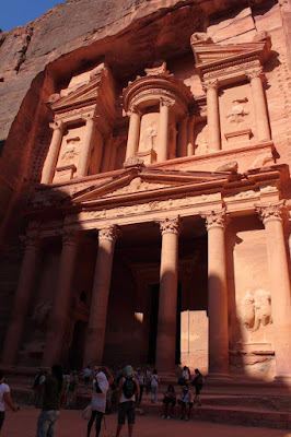
Petra - The Treasury.
As we approached the end of the Siq, a guide for another tour group started humming the Indiana Jones theme.  Why, you ask?  Well, at the end as you turn a slight corner you see possibly the most spectacular, and most recognized, ruin of Petra - the Treasury - famously showcased in Indiana Jones and the Last Crusade.  The carved facades are memorials and tombs of wealthy and/or powerful Nabataeans who made Petra their capital sometime in the 6th century BC.  This would make Petra the oldest ruins that I've ever been to - very cool.

Our guide took us along the winding canyon pointing out other facades and, eventually, more Roman ruins.  Petra has changed hands many times in its lifetime.  The last residents, Bedouins, left in the 60s after King Hussein payed them a personal visit to ask them to leave so that it could be preserved.  In return for them leaving, they were given a new village not far away and they were allowed to work and sell things in Petra.  Most of the vendors we saw in Petra were Bedouin.

We wandered down the canyon admiring the swirling strata of the stone (I had better pictures of the stone but my camera card decided, after this picture, to take a crap and they all went *poof*).  We looked into one chamber to see the burial niches.  We passed Roman temples.  Our guided tour ended at a museum.

At this point we were given choices.  The afternoon was ours to do with what we pleased.  Our guide had told us of another facade known as the Monastery.  By the way, the names given to these facades have nothing to do with what they were used for.  They were all tombs.  The treasury was not a bank.  The Monastery never had monks.  The Monastery lied past the museum ... up 900 steps.  It was probably in the high 90s or low 100s Fahrenheit.  I looked at the Wife and she said Hell Yes.  We hadn't traveled all this way to be turned away by a few steps.

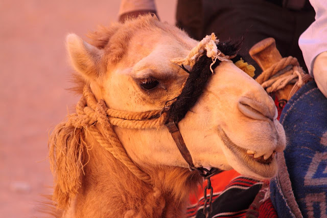
What Would Jordan Be Without A Smiling Camel.
The steps were not all contiguous.  You would walk up a few dozen steps hewn in the stone and then hit a flat stretch.  The path up twisted and turned in and out of shade.  In the flat areas small Bedouin shop keepers had set up tents where you could get shade and buy crafts.  We were passed by surefooted donkeys carrying tourists up the stairs.  I let the Wife set the pace as I figured my usual pace would be too fast.  We were doing pretty good.  Soon we could see a large tent, larger than all the others, up above our heads.  Thinking this was our destination we pushed ahead.  It wasn't the Monastery but it was the location of our most memorable Jordan vacation moment.

I reached the big tent first.  The tent covered a large rest area with chairs, a jewelry store full of Bedouin jewelry, and a snack bar.  I turned around looking for the Wife.  She looked winded so I tried to steer her to one of the chairs.  She passed me, ignoring the chairs, and sat on a step.  I wondered what was happening when she started wheezing, crying, and said she couldn't breathe.  She was having an anxiety attack and hyperventilating.  I tried to calm her down.  She laid flat on her back gasping loudly.  Two French women came over and fanned her with their hats.  I got up and bought cold water and rushed back.  I got back in time to hear one of the French women, her face only a few inches from the Wife's face, say:
"You must promise me you will hire a monkey.  You must ride the monkey down. You must have you husband hire you a monkey."
Now, this was a very confusing thing to hear.  I was confused and you could see in the Wife's eyes that she was thinking about what the French woman was saying.  All this talk of hiring a monkey distracted the Wife so much that she forgot that she couldn't breath and she stopped hyperventilating.  The Wife said later that she was thinking "She means Donkey but she's saying Monkey" and she didn't know if she should laugh or not.  We think that the effort and the heat had combined to deprive the Wife of air which triggered the anxiety attack.

The Wife recovered and downed the water bottle.  I asked if she wanted to go back and she insisted on continuing so, after we had rested a while, we continued.  The Monastery was only about ten minutes further ahead.  At the top there was a very large, lush Bedouin tent with carpets, pillows, hookahs, tea, and cold drinks.  Opposite the tent was a huge facade.  Very impressive and worth the climb.  Because of reasons beyond my control ... damn camera card ... the only picture of the Monastery is a scan of a postcard the Wife bought.

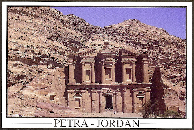
The Monastery - Resorting To A Scanned Postcard - Damn Camera Card.
I left the wife at the tent and went up to some view points.  At one of these viewpoints was a geocache.  I figured it was my last chance to find one in Jordan.  To get to it you had to walk out on a four foot ledge with a knee shaking drop off and search the pock marked cliff face.  I searched and searched and did not find it.  My GPS said I was two feet away from it at one time.  It probably was gone.  Or maybe I was just too tired to see it.  I left Jordan without finding a single geocache.

I rejoined the Wife and we headed back down.  Going down is so much easier.  We stopped at a lunch place near the museum at the bottom and ate ... a buffet lunch.  After eating and drinking our fill we headed back up the canyon to our hotel.  Since it was the afternoon, the temperature had gone up several degrees since the morning and it was really, really hot.  By the time we got to our room we were exhausted and a bit ripe, if you know what I mean.  We had been walking around Petra for about nine hours.  We walked about 10 miles per my GPS (Actually it said 11.67 miles but GPS reception was shaky in some of the valleys and the track actually shows me walking through solid stone in some places so I'm guessing it over did it on the distance).  The vertical, from the museum up to the Monastery was 768 feet.

After showering and cooling off a bit we were crazy enough to go back out and do some shopping.  Prices were pretty reasonable as it was the off season.  We even negotiated for some ice cream.  If we'd known the ice cream was so good in Jordan we would have bought some sooner.  Those Eskimo Pies were awesome.

The last of my pictures have been added to my 2010-07 Jordan Google Photos album.

Tuesday, July 20, 2010

2010 Vacation: Jordan - Day Four - Madaba, Mt. Nebo, And Al Karak

Jordan is a Muslim country.  Some 94% of the Jordanians are Muslim.  The rest are mostly Greek Orthodox.  After spending three days exploring Muslim, Roman, Byzantine, and Ottoman cultures, day four of our Jordan vacation was primarily focused on Christian culture.

We checked out of our Amman hotels, got on our short bus, and headed south.  Our first stop was the city of Madaba.  The city of Madaba is roughly 45% Christian.  One of the first things I noticed as we entered the city were signs advertising liquor and beer.

In Madaba we stopped to visit an example of the Christian churches of the area, the Greek Orthodox Basilica of Saint George.  The church is known for it's extensive mosaics including a mosaic map of the holy land dating back to the 6th century.  Our guide took us to a room with a blowup of the map and explained several landmarks on the surprisingly complete map before we entered the basilica to see it for ourselves.

Basilica of St. George - Mosaic Map of the Holy Land
From Madaba we went to nearby Mount Nebo, the supposed location of Moses' death.  There is no physical proof of this but it has been visited by two Popes so I presume is is accepted by the church.  From the top you do have some awesome views of Jericho and the Dead Sea, despite the ever present sandy haze.  This is where God gave Moses a view of the promised land before burying him, somewhere, on the mount.

There is a 4th century church and monastery on the highest point but it was being restored and we could not go in.

Near the entrance of Mount Nebo is a sculpture with representations of Jesus, Moses, and Mohamed.  While the faces of Jesus and Moses are fairly detailed, Mohammed's image is vague to satisfy Islam's prohibition on images of the prophet.

General Tours, our tour company, has a custom of taking it's guests to one charity location, a way to give back to the host country.  In Peru it was an orphanage in Cuzco.  In Jordan it was a mosaic factory outside of Madaba, and not far from Mount Nebo, that employed women and  handicapped artisans run my Queen Noor's charity foundation.  It was interesting.  We learned how mosaics were made and we had the chance to buy the finished products.

Farther south we passed through the "grand canyon of Jordan", Wadi Mujib ('Wadi' means valley in Arabic).  We stopped at a viewpoint and admired the beautiful water-worn landscape and one of the dams that was slowly choking the Dead Sea.

Wadi Mujib
Lunch time approached and we pulled into the city of Al Karak.  We ate at a restaurant facing the crusader castle of Kerak.  After another tasty buffet lunch, we explored the castle.  The crusaders built the castle in the 1140s.  The castle had been used and reused, built and rebuilt, many times over.  The castle felt bigger that the Saracen Castle we'd seen in Aljun.  There were tunnels running under the castle that we were able to walk through.  It was pretty cool.

A Chamber in the Kerak Crusader Castle.
There was a geocache at the castle which I failed to find.  My geo-senses and my luck just weren't working on this trip.

Kerak was the last stop today.  The rest of the day was a driving south, passing by dry farm fields and desert landscapes, ending in Wadi Musa, a town located near Petra.  Our hotel was only a few hundred feet from the entrance.  We checked in and got to our room in time to watch the sunset.  Pictures can be found here.

Sunset Over Wadi Musa.