UPDATED 11-11-2020
Mentally I'm feeling up. I've given up on a trail family. I just enjoy the people I encounter until it's time for them to move on. Now that I've come to accept this fact of the trail, I have been doing much better mood wise.
 |
| Another gorgeous day on the AT. |
I left the B&B I stayed at in Damascus at 6 :10am and walked out of town. The AT follows the Virginia Creeper bicycle trail for a while. At one point you are walking into bicycle traffic which was a bit nerve racking since there were a lot of little ones on bikes who didn't quite know what to do when they were heading for a hiker.
After crossing a long bridge the trails diverged and we hikers were safe once again. Like most other towns, the trail climbed out of Damascus. I arrived at my stop, the Lost Mountain Shelter at 15.8 miles (25.4 km). My plan was for this day to be the longest in this section of the trail but things would change as they often do.
 |
| One of the Grayson Highlands ponies. |
My stop for the day was Thomas Knob Shelter, not far from Mt. Rogers the tallest point in Virginia, and just outside of Grayson Highlands State Park. The park is famous for its wild ponies. The ponies were introduced into the park to control the growth of grass and weeds in the park. The ponies are periodically rounded up and checked by veterinarians. As I got closer to the shelter I was passing ponies in the nearby fields and stopped to watch a pony licking the salt off a hiker's arm.
At the shelter a mama horse and a couple yearlings came into camp and proceeded to lick salt off of everything they could get their tongues on. I kept a large rock between me and the horses.
I talked with Dayglo, Lumberjack, and Achilles as the horses licked off salt. That night a horse stood outside the shelter and stared in most of the night.
 |
| The view in the Grayson Highlands. |
There are several paths through the park including former AT trails. Some hikers took alternate (shorter) AT routes that took you by the blooming rhododendron bushes that are all along the southern AT. I stuck to the longer route.
The trail left the highlands and the ponies behind, passing by the pen where the ponies are gathered for medical exams, and dropped down to my stop of the day, the Old Orchard Shelter. The day was again fairly short at 11.9 miles (19.2 km) but the rocky trail made it a difficult day.
The trail left the highlands and the ponies behind, passing by the pen where the ponies are gathered for medical exams, and dropped down to my stop of the day, the Old Orchard Shelter. The day was again fairly short at 11.9 miles (19.2 km) but the rocky trail made it a difficult day.
Sunshine showed up with a bump on her head. She'd tripped and possibly lost consciousness briefly. She was found by Tarzan\ sitting on the side of the trail.
I met my first shelter log groupie here. He stopped for a rest and asked our trail names. He'd been following several people by their shelter log entries. He found Tarzan who was there and then said he thought he was close to Little Hill. I raised my hand and I thought he was going to jump for joy. He was very excited. My entries are not elaborate and just say what I'm doing. I do have a logo that I use though which probably attracted his attention. He was travelling with two hikers (Captain and … I do not recall her trail name) who later would be famous for doing a fifty mile day.
I met my first shelter log groupie here. He stopped for a rest and asked our trail names. He'd been following several people by their shelter log entries. He found Tarzan who was there and then said he thought he was close to Little Hill. I raised my hand and I thought he was going to jump for joy. He was very excited. My entries are not elaborate and just say what I'm doing. I do have a logo that I use though which probably attracted his attention. He was travelling with two hikers (Captain and … I do not recall her trail name) who later would be famous for doing a fifty mile day.
My watch band broke here as I was talking to Jug, Phoenix, and their dog. I was a bit miffed since I'd worn a watch ever since I was a kid. My mood was lifted by the eggless cookie dough dip Phoenix shared. Phoenix was a cook who was planning to open a food truck and all their food was homemade. They were a very nice couple. I'd seen them on and off for a while now (can't remember when we first met) and I would see them on and off until Waynesboro, VA. I haven't worn a watch since.
One more thing. At this shelter I met BooBoo. When we asked him what his story was he said he was hiking the Continental Divide Trail (the CDT passes through New Mexico, Colorado, and northward along the Continental divide). He clarified that in 2017 he'd hiked the AT. In 2018 he'd hiked the Pacific Crest Trail (the PCT goes through California all the way up to Washington state). He's started the CDT this year (2019) but when he got to Colorado the snow hadn't cleared yet so he came to the AT to keep his hiking legs going - The Damascus to Marion section was his favorite. When he finished the CDT he would become a triple crowner.
Day 57 - This was going to be another short day but, after talking over the plan with Tarzan, Cali Butter, Sunshine, Sister, and Vagabundo I decided to push for a longer day. This would allow for an earlier entry into town.
The day went well. I stopped at the Trimpi Shelter for a snack, a privy break, and a little nap. I chatted with Hornet who was trying to decide if he wanted to go on or not.
I pushed on heading for a campsite next to a water source. I reached the site but there was no water. I climb the hill more looking for water and found none. I dropped my pack at a campsite and headed a half mile back down the hill to a stream I'd crossed earlier and hauled the water back up. I did 17.0 miles (27.4 km) today not including the running up and down the mountain for water.
As I was trying to get my breath back I heard thunder. I quickly put up my tent and started eating my evening meal but then I felt drops. I put my unfinished meal in my food bag and looked for a place to hang it before it really started to rain. I had a hard time finding a place to hang when the rain got stronger so I got in my tent with my food bag.
There had been a lot of bear activity in the area and having your food bag in your tent was not a wise thing. As I sat there listening to the rain I swore I heard deer, bears, and other hikers putting up their tents.
It poured for an hour or so then reduced to a drizzle. When it finally let up I got back out and successful hung my bag. There was no on there. No deer. No bears. My mind likes to play with my head.
Days 58 & 59 - I woke up to an empty campsite. All the others who planned to join me stayed at the Trimpi Shelter when it rained and hailed over there. I was lucky I didn't get hailed on.
I packed up and headed out. Along the way I heard a crack of a breaking branch. I looked down the ridge and saw my first black bear running away from me. I wasn't very close and it wasn't very big. I didn't have time to get a picture.
Despite of only hiking 6.4 miles (10.3 km) I was tired when I got to the Pat Jennings Visitor Center probably because I hadn't eaten my dinner last night. I called for a 50¢ shuttle ride.
Day 57 - This was going to be another short day but, after talking over the plan with Tarzan, Cali Butter, Sunshine, Sister, and Vagabundo I decided to push for a longer day. This would allow for an earlier entry into town.
The day went well. I stopped at the Trimpi Shelter for a snack, a privy break, and a little nap. I chatted with Hornet who was trying to decide if he wanted to go on or not.
I pushed on heading for a campsite next to a water source. I reached the site but there was no water. I climb the hill more looking for water and found none. I dropped my pack at a campsite and headed a half mile back down the hill to a stream I'd crossed earlier and hauled the water back up. I did 17.0 miles (27.4 km) today not including the running up and down the mountain for water.
 |
| A three to four foot Black Snake on the trail. |
There had been a lot of bear activity in the area and having your food bag in your tent was not a wise thing. As I sat there listening to the rain I swore I heard deer, bears, and other hikers putting up their tents.
It poured for an hour or so then reduced to a drizzle. When it finally let up I got back out and successful hung my bag. There was no on there. No deer. No bears. My mind likes to play with my head.
Days 58 & 59 - I woke up to an empty campsite. All the others who planned to join me stayed at the Trimpi Shelter when it rained and hailed over there. I was lucky I didn't get hailed on.
I packed up and headed out. Along the way I heard a crack of a breaking branch. I looked down the ridge and saw my first black bear running away from me. I wasn't very close and it wasn't very big. I didn't have time to get a picture.
Despite of only hiking 6.4 miles (10.3 km) I was tired when I got to the Pat Jennings Visitor Center probably because I hadn't eaten my dinner last night. I called for a 50¢ shuttle ride.
As I waited for the shuttle the others showed up and the stories started. Hornet asked if anyone had dropped a Handkerchief. The women in the group snickered a bit before explaining to him that it was a pee rag. He made a disgusted face and dropped it in a trash can.
Achilles began giving his food to other hikers. They all asked why and he said that he was a section hiker and was getting off trail in Marion. Everyone was shocked. He'd been on the trail since Springer Mountain and I'd seen him since the Fontana Hilton. He just didn't like goodbyes so he didn't tell anyone he was only hiking a section - a long section - of the AT.
We saw a car drive in with the driver sitting in the passenger seat. It was the local mailman and he had learned how to sit in the passenger seat and still drive his standard wheel on the left car.
This was a nice little moment on the trail. The shuttle arrived and we went into town.
I checked into a hotel, walked over a mile to do my laundry, ate, and started planning my next section. Resupply would be scarce going forward so I would have to find alternatives to carrying a ton of food. Some of the alternatives may make for good stories next post.
I checked into a hotel, walked over a mile to do my laundry, ate, and started planning my next section. Resupply would be scarce going forward so I would have to find alternatives to carrying a ton of food. Some of the alternatives may make for good stories next post.
Pictures can be found in my 2019 Appalachian Trail Google Photos album.
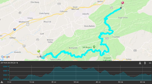
Total Distance: 534.2 Miles (859.7 km)
Section Distance: 64.1 Miles (103.1 km)
Section Elevation Up: 12,578 ft (3,834 m)
Section Elevation Down: 11,379 ft (3,468 m)
|

No comments:
Post a Comment