Homer's Travels: March 2010

Tuesday, March 30, 2010

Covered Wagons, Tee Pees, Churches, And Wimp Outs

I was planning to bicycle to today but I wimped out when I saw how windy it was going to be.  Bicycling, to me, is recreation and exercise is secondary.  Wind means it's no fun therefore it's not recreational.  I stayed in bed.

Since it was going to be a nice day I decided I needed to get out of the house so I drug myself out of bed and got in the car and headed west to check out an old, decaying church that I'd passed several times on my way to somewhere else.  I thought there might be a photographic opportunity or two to be had.  Besides the church there was also the world's largest covered wagon and an old motel nearby.


I pulled off the nearest exit and, after driving around, realized there wasn't any road to the church.  It was on private property and the number of large Keep Out Signs and No Trespass signs was a little discouraging.  I pulled over in front of the covered wagon and took some pictures.  The covered wagon-like building was originally a gas station but now is a golf shop.


I walked across the road to take pictures of the dilapidated remains of the trailer park/motel.  The original owner of the covered wagon, the motel across the street and, turns out, the church died many years ago (over 10 years ago at least) and the place is showing the effects of years of neglect.  The only thing remaining is an old barn with "Souvenirs" painted on it's roof, a large tin tee pee that, I've heard, you could spend the night in once, some decaying playground equipment, and old signs.  As I took pictures, I realized that I could probably walk along the fence to where the church and a small house/building were.


I walked along the fence on what was once Westward Ho Trailer Park road.  Now it's just a grass covered path.  I reached the church and started taking pictures.  Would you believe that the camera batteries decided to go dead right about then?   Yes, I always carry an extra set.  Yes, the extra set is in my camera bag.  Yes, my camera bag was back on the passenger seat of my car.  When I got out of the car to take pictures I didn't expect to go too far so I'd left the bag in the car.  Pi$$ poor planning on my part.  I did manage to squeeze out a few more pictures before turning back.


On the way back I noticed part of the fence had been pushed down by some unknown interloper.  I could have easily gotten through the fence.  For the second time today I wimped out.  Why climb through the fence and explore the church up close when my camera was dead.  That's the excuse I gave myself anyway.  Nothing stopping me from going back to the car, changing batteries, and walking back.  I didn't do that though.  Something for another day.

I added the pictures to my 2008-2010 Rural Nebraska Google Photos album.

Saturday, March 27, 2010

Hiking Iowa: Wabash Trace Nature Trail - Coin to Bingham

Friday I went out for my long hike for the week.  My destination: the southern end of the Wabash Trace Nature Trail.  The stretch I would be doing starts in the small town of Coin, IA (I snowshoed here last December) and head north west to the even smaller town of Bingham, IA.  (I should really put a map together showing the parts that I've completed.)  This stretch is about seven and a half miles long so I was aiming for a total of fifteen miles for the round trip.

The Wabash is pretty consistent from one end to the other - a straight, level, crushed limestone trail often bordered by trees that, once they are leafed out, form a a canopy over the trail.  This part of the Wabash crosses farm land with a few river and creek crossings.  As I walked along the trail I wondered if there would be anything to post about.  I saw wildlife (turkeys, deer, pheasant) and  evidence of wildlife (Chirping birds, coyote scat, prints galore, and the nearly deafening chirping of frogs in water along the trail).  Nothing I haven't posted about before.  About five miles north west of coin I got my answer: Benches.

"Benches?" you ask.  What can be said about benches?  Most of the benches I have encountered on the Wabash are your standard bench stuck in the ground.  Most of  the benches along the trail are dedicated to someone.  This affects bench placement as they are often placed in the memorialized person's favorite part of the trail.  This often results in long stretches without benches and then a cluster of two or three benches within five hundred feet or less of each other.  I wish they would be distributed more evenly.  But, while this is also true for this stretch of the Wabash, there is something special about the benches between Coin and Bingham: originality.

The first bench, the most interesting one that I've ever seen, is at a large bridge crossing the Middle Tarkio Creek ( I would call it a river but I guess it's too small for riverhood).  It is one of three with five hundred feet of each other (of course), the others being benches built into the long bridge and a covered picnic table.  Here is the bench:

Why aren't they all like this?
The inscription says "In Memory of Joyce & Donnell Hullman 'Sit down, you're making me nervous.' - Don".  I didn't use the bench on the way out (I'd stopped at the picnic table) but I did use it on the way back.  I have to say that it is as comfy as it looks and I found it difficult to leave.   If there had been less wind, I would have probably fallen asleep.  I guess that's why they're not more common.

The other interesting bench was at my turn around point of Bingham.  Now, I like small towns but Bingham is too small.  If I hadn't known it was there I would have missed it.  It basically is a small cluster of farm houses. I don't think there are any businesses there.  There was a building that could have been a mechanic or a farm implement store but, more likely, it was some farmers tractor shed.  The road through town wasn't paved.  Heck, it wasn't even dirt.  It was a mowed strip of grass.  When I first saw it I thought it was someone's lawn then I realized it was too long and thin and it matched the map on my GPS.

Back to the Bingham bench.  The bench is a porch swing under a tin roof.  Scrawled in the concrete were initials and "94" meaning it was erected in 1994.  Also there was scrawled "BURT PATTLIN 2-18-21"  Not sure if this was dedicated to him or if he was the one who built it.  It was a very nice swinging bench:

One swinging bench.
Another notable thing about this hike was my blister bandaging experiment.  To protect the large blister on the ball of my right foot, I wrapped a tight ace bandage around the foot.  The problem was, when I put on my socks (Omni-Wool hiking socks which are very tight) the bandage shifted toward the rear of my foot.  When I finally sat on the cool curvy bench, I removed my shoe and sock, re-wrapped the foot, and figured out how to put the sock on without shifting the bandage.  For the next five miles ... let's just say that the bandage was a bad idea.  A really bad idea.  When I got home I had two blisters on the ball of my right foot.  The two blisters have since merged into one huge blister.  Sigh.  Next week, no long hike.  I need time to heal.

Benches and blisters, these are the notable things about this hike.  I did three geocaches.  One ("Coin Treasure") was near an old abandoned school in Coin.  I would love to explore it but, by the holes in the ceiling you can see through the broken windows, I don't imagine that the inside would be safe.  Can't imagine what the rain and snow has done to the inside.  Still would like to go in though.

Total distance for this hike was 16.15 miles (I walked around Coin a bit and added almost a mile).  Photographs I took on the hike and in Coin can be found in my 2009-2013 Wabash Trace Nature Trail Hike Google Photos album.

Tuesday, March 23, 2010

Blisters, Lakes, And A Golden Spike

I went out for a short walk today to see how the blister would affect my walking.  I decided to walk around Lake Manawa, a left over from a Missouri River Flood back in 1881.  The walk was short and sweet, clocking in at 6.46 miles.  It was probably a little too chilly for a good walk and the trees still look pretty drab without their leaves.  I'll have to come back later in the spring.  I did manage to find a geocache ("North Shore").

My feet faired well.  Yes, I can feel the blister on my right foot (the bigger of the two) but it didn't really bother.  I'm thinking about doing a longer walk on Friday and, if I do, I will try wrapping the ball of my foot to provide some extra cushion.

On the way home, after a quick lunch, I decided to stop by a monument in Council Bluffs.  The monument, a large golden spike, is located in a somewhat rundown part of town in a park sandwiched between industrial sites and a trailer park.  The plaque affixed to the base of the monument says that it commemorates the eastern terminus of the Union Pacific railroad (i.e. the transcontinental railroad).  The truth is a little less dramatic.  The monument was erected to publicize the 1939 movie "Union Pacific".


Saturday, March 20, 2010

You Know You're Visiting Friends From The Mid-West When ...

We visited the Loon Whisperer's place this afternoon.  We actually got to see her husband - I don't think I'd seen him for almost a year and a half.  The visit was fun.  The girls are getting older, growing taller, and more talkative.

The best was when we left, they gave us two Buffalo T-Bone Steaks.  The steaks came with a warning: If you grill them, watch them carefully as buffalo fat is very flammable.  This was learned at the expense of a grill and a fire extinguisher.  Heh.

You know you've visited friends from the Mid-West when they send you home with meat.  Thanks guys!

Thursday, March 18, 2010

Pre-Spring Spring Day

Today was an absolutely gorgeous pre-spring spring day.  Blue Sky.  Temperatures in the 50s and 60s.  Turned out to be a perfect day for a walk.

It had been over a month since my last walk, weather and roadtrips conspiring to keep me house and car bound.  I left after breakfast (and the Daily Show) and headed on foot over to my doctor's office to pick up my test results from the blood that was drawn earlier this week.  I stuffed the results without looking at them into my backpack and headed south to the Walnut Creek Recreation Area.  

Walnut creek is kind of a misnomer.  The place is less a creek and more a large pond ... or maybe a small lake.  There is a three mile path around the pond that I'd bicycled a few months ago.  The water was half frozen and there were a small flock of Canadian geese walking around on the ice.  I guess they prefer ice to water.

Taking one of my lessons from Kansas to heart, I took the time to load my GPS with sixteen geocaches and I found five on the way to Walnut Creek, another two at Walnut Creek, and one more on the way back from Walnut Creek.  The remaining eight had either disappeared (not uncommon with geocaches) or I just decided to try them some other day as I was a little worn out from all the walking.

On the way back I stopped at an Arby's for a large roast beef sandwich, a medium curly fries, and a medium diet Dew.  While I ate this most unhealthy of meals, I pulled out my test results and went through the numbers.  They weren't as bad as I expected.  I'd managed to get my numbers under control before the last test in September but I'd been a little lax in my nutritional discipline lately.  Turns out my numbers did go up a little but were still all in the normal range.  The only number that sucked was my HDL (good cholesterol) which has always been low.  I'll have to do some research to see what I can do about my low HDL numbers.

When I finally got home I had walked 16.23 miles and had a couple blisters on the balls of my feet.  I think this is because all the walk was on concrete.  When I've walked on softer trails in my walking shoes (I wasn't wearing my boots) I never get blisters.

Oh yeah, when I was a couple doors down from our house I spotted one of our runaway Christmas balls.  Now I think we're only missing one or two ... or maybe three.  Icing on the wonderful spring-like day cake.

Tuesday, March 16, 2010

Kansas Teachings

So, when it is too late to post about a roadtrip and how many trips back to that well are you allowed?  I've already milked our Kansas roadtrip for three posts and here comes one more.  I believe it will be the last.

I've always seen vacations as having two purposes: to provide a change in your routine, a break from the ordinary, a time for rest and relaxation; and to learn something, discover something or some place new.  The Kansas roadtrip satisfied both of these purposes.  The first was easy.  Three days on the road, out of the house, in a state that I've never been before, was definitely a change of pace and was fairly relaxing.  The second ... well the second calls for a list.
  • One of my on again off again hobbies is geocaching.  It is often a good compliment for hiking as there are often caches hidden along interesting trails.  When we lived in California I used geocaching to introduce me to new trails.  When I planned our Kansas trip I discovered a reference to the oldest active cache near Mingo, KS.  What I did not do was check out caches in other places where we were going.  It turns out that there were caches at geographic center of the lower 48, the biggest ball of twine, Nicodemus, Wakeeney, Monument Rocks (2!),  Greensburg, Kinsley, the Cathedral of the Plains, Lucas,  the Atomic Cannon, and Stull.  It would have taken me only a few minutes to check this out before the trip and to program my GPS.  From now on, I will check for caches in the area and be ready.
  • The most profound realization I had was in Lucas at the Grassroots Art Center.  I have written before about my taste in, or more correctly my lack of interest in, art.  At times I thought there was something wrong with me or that I needed to take art appreciation classes.  After seeing the myriad types of folk art at the center - pull tab, chewing gum, peach pit, grapefruit rind, limestone, welded metal, concrete, and barbed wire - I realized that I like folk art.  I like art made by the common person.  As the Wife said it, it was art without the snootiness.  I'm not exactly sure if that explains all my disinterest in classical art but it's part of it.  Thinking back, I remember being fascinated at Elmer's Bottle Forest, Salvation Mountain, Nitt Witt Ridge, M.T. Liggett's place, the Garden of Eden, and the Grassroots Art Center.  Now, when I plan a roadtrip, I will keep my eye out for art ... folk art, that is.  Here is another piece of folk art at the Grassroots Art Center:
  • The last thing discovered is that skunks have issues with crossing the road in Kansas.  We counted over 20 dead skunks on or near the road.  They vastly outnumbered all other types of roadkill.  This seems odd when you consider we saw eleven plus turtles crossing the road during our vacation last June and nary a dead one.

Friday, March 12, 2010

The Signs Of Spring Are Upon Us

I'm starting to see the first signs of spring around here. The snow is mostly gone despite the dusting we got yesterday. Rain has become more common.  The highs are higher though the days have been overcast.

I saw my first robin on Wednesday and a couple more on Thursday sitting in a tree wondering what all this white stuff falling from the sky was. Another sure sign around here are the flocks of birds passing through on their way north. I caught this huge flock stopping for a dip in the flooded farm field out our back window:


Not sure what type of birds they were. They didn't honk like geese would. I'm guessing some sort of duck. (Another Picture here.)

Thursday, March 11, 2010

Kansas Roadtrip - Day Three: Cathedral, Eden, Folk Art, Cannon, And Hell

Day three, the last day of our Kansas wanderings, started with a Cathedral in the town of Victoria, KS.  Actually, for the Wife, it started earlier with the revenge of last night's dinner.  Nothing like a little food poisoning on top of the cold she was recovering from.

The Cathedral of the Plains was built between 1908 and 1911 by German immigrants but there appears to be a Russian/Eastern European influence in the area. We decided to visit the cathedral after the Wife saw how catholic northern Kansas was. The cathedral, like most large public buildings in northern Kansas is built of yellow limestone.  It's pretty impressive but I was more interested in the statues near the cathedral which had a distinct Russian feel to them. (Cathedral of the Plains pictures can be found here.)

As we started with a religious site, our next stop could be nothing but the Garden of Eden located in nearby Lucas, KS.  The Garden of Eden is an outdoor folk art garden.  Built by S.P. Dinsmoor after he retired from farming, the garden consists in a limestone "log" cabin (the limestone logs are notched and stacked just like a real log cabin), a limestone pyramid mausoleum, and concrete statuary of biblical, masonic, and historical figures.  Dinsmoor used his art to express his freethinker political views.  The place opens in the afternoon but the Wife had called the day before and asked if they could open the place early for us.  They said sure, no problem and we ended up with a private tour.  The tour started with a video discussing local history include history of the limestone quarry in the area.  We then wandered around the house before getting a guided tour of the yard where all the statues are and the mausoleum.  The weirdest part of the mausoleum is the concrete and glass coffin housing S.P. Dinsmoor is all his rotting glory.  Yes, you could actually see his decomposing body including the remains of his long beard.  Pictures in the mausoleum were prohibited which was fine since it was kind of creepy and a little gross.  (Garden of Eden pictures can be found here.)

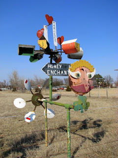
We almost left Lucas at this point but decided to stop by a gallery on main street called the Grassroots Art Center.  As we parked in front I asked the Wife if the metal sculpture in front of the center looked familiar.  It was an M.T. Liggett sculpture.  The place was awesome.  The director of the center showed us around.  She was wonderful.  She was a real promoter of folk art, telling us all about the artists and even allowing me to take pictures.  The art varied from concrete and glass sculpture to portraits done in chewing gum (!!!) to buildings carved out of limestone to a full size motorcycle and car made of beer can pull tabs.  (A close up of the pull tabs is here.)  After taking us through the center she took us to a nearby house to show us more (another center person described it as the O-Zone).  This house was left empty when the artist/resident passed away.  Another artist asked if she could stay in the house if she produced art.  They agreed provisionally to see what she would produce.  Well, produce she did.  We walked in and ... said "Oh!"  The ground floor rooms are completely full of pieces - mostly Barbie art she calls Rebarb.  Floor to ceiling.  The place was amazing.  There was even a poster on the wall that I had when I was 7 (A solar system poster).  Truly incredible.  In the backyard there were cement sculptures of places the former resident had vacationed.  If I ever win the lottery I'd be tempted to move to Lucas and be creative. (Grassroots Art Center pictures are here.)

We ended up spending way too much time in Lucas.  When we left we were about two hours behind schedule and frankly, I didn't care.  This vacation was a pseudo-random delight and we still had more to go.  We stopped in the town of Wilson, the Czech capital of Kansas, for a brunch that, due to the late hour turned into lunch.  We ended up eating at a  restaurant suggested by the Garden of Eden tour guide.  When we sat down the Wife looked up and pointed out a flier hung up near the cash register - it was for Barefoot Becky.  Barefoot Becky and the Ivanhoe Dutchmen was the polka band that played at our wedding (Yeah, we had a polka band at our wedding! - I'm excited and I don't even dance!)  Very cool and the hot beef open face sandwich with mashed potatoes and brown gravy was great too.

We got back on I-70 heading east this time.  Our next stop was just past Junction City.  Up on a hill, overlooking the freeway and Marshall Airfield, is an Atomic Cannon.  How cool is that!?!  The Wife was not quite feeling well so I hiked up the hill alone to take pictures of the big cannon.  The things pretty big.  Very cool in a little boy way.  (Atomic Cannon pictures are here.)

Continuing east we headed for our last destination on this three days of roadtrip weirdness.  Our final destination, as it were, was the town of Stull, home of the Gates of Hell.  Stull is just southeast of Topeka and the forces of evil traffic were fighting us all the way.  After almost three days of back road driving not seeing a car for miles/hours, the increase in traffic around Topeka started to irritate me.  Finding a place to get gas, snacks, and bathrooms proved a near impossible task.  By the time we reached Stull, after a wrong turn or two, a toll road, and after finding the cemetery with the remains of the supposedly haunted church remains, we decided not even to stop.  There were reasons.  A chainlink fence with a multitude of No Trespass signs was one reason.  Another is that I'd read online that the residents of Stull weren't very keen on their local tourist attraction.  Making it worse, one of the legends says that bottles thrown at the old cemetery church would not break.  This results in all kind of yahoos throwing bottles into their cemetery.  I don't blame the cemetery owners.  It had also been a long day for us.

We drove back to Topeka to catch a road north back home.  By the time we got out of Topeka, I'd really felt like I'd been to the gates of hell and back.  (Before anyone complains, I'm sure Topeka is a perfectly wonderful city.  I exaggerate based on my heightened state of irritability as I drove through your town.)

The rest of the drive was without incident ... well, except for the warning for doing 40 MPH in a 35 MPH zone in Auburn, NE that is.  I'd been so careful to slow down through towns but I slipped on the last day.

We got home after dark and it was nice to be home after three days and some 24 hours of driving.  Now my only question now is: Where to next?

Wednesday, March 10, 2010

Book: John Scalzi's "The Last Colony"

Last year I read John Scalzi's books "Old Man's War" and "The Ghost Brigades".  I liked both books.  They took me back to my youth when the military space opera was one of my favorite genres.  "The Last Colony" is a good third book in the series.

"Old Man's War" introduced us to John Perry and Jane Sagan (a clone of John Perry's wife in the special forces).  "The Ghost Brigades" followed Jane, fleshing out her character and the world of the special forces.  "The Last Colony" reunites John and Jane, marries them, gives them an adopted daughter (a character from "The Ghost Brigades"), takes them out of the military, and throws them headlong into politics and intrigue.

The story is interesting as we watch the characters adapt to their new roles as colony administrators trying to set up a new colony.  While they are not in the military anymore, there was more than enough action to keep me interested.  I enjoyed it so much that I finished the book in a week which is pretty good for me.

The book is not perfect though.  There is a story line, concerning intelligent life on the planet they are trying to colonize, introduced a third of the way into the book, that disappears and is never resolved.  Many of the solutions introduced during the climax come out of left field and were a bit too pat.  Despite these issues, I really did enjoy the book and if you liked the other two books, I recommend this one as well.

There is a fourth book, "Zoë's Tale",  that apparently follows the same events of "The Last Colony" seen through John and Jane's Daughter, Zoë.  I've read similar books and they are hard to do.  It is hard to make it consistent and original at the same time and the books often feel like a rehashing of an old story.  I haven't decided if I will read this one.

Tuesday, March 09, 2010

Kansas Roadtrip - Day Two: Cache, Rocks, Hairballs, And Folkart

Day two started in Wakeeney, KS.  We got on interstate 70 and headed west towards Mingo, KS.  Our first destination was not the town but a geocache near the off-ramp.  The "Mingo" cache is a special cache as it was the seventh cache ever placed (May 2000), the first one in Kansas, and is believed to be the oldest active cache.  I took an homemade, trackable, "geocookie" which I'll drop off somewhere in Nebraska or Iowa.

After finding the cache we backtracked on I-70 on our way to Monument Rocks.  Unfortunately we figured out the correct exit after we'd passed it - our second wrong turn on this trip.  The Wife used her navigation skills, skills that were very helpful on this trip, to get us back on track.  We left the interstate and barreled down a dirt road that got us back to a two lane asphalt road heading south.

Twenty minutes later we turned onto another dirt road and headed into another world.  Monument Rocks just doesn't belong in Kansas.  Kansas is supposed to be flat prairie, not this rocky, desert looking place.  The formations reminded me a little of the Pinnacles in California.  There were two outcroppings and we stopped at both to look around and take pictures.  It's kind of surprising that they have survived for so long and the rock is very soft.  As we left the rocks I saw a marker by the road.  The limestone pillar was a marker for the Butterfield Overland Dispatch Stagecoach marker.  (Monument Rocks pictures are here.)

We returned to the asphalt and found a sign for the Keystone Gallery.  With images of magnets dancing in our heads we headed there to see what they had.  The place looked a little odd - dumpy, interesting, eclectic.  There was a house and a gallery building.  As we pulled into the parking lot, a hairy dog trotted up to the car before I was even stopped.  I open my door and it stuck her head in and gave be a good sniffing.  We got out and walked to the gallery.  The was impeded by the friendly dog who rolled on the ground and assumed the rub-my-belly position several times.  We obliged.  In the gallery we found a combination gift shop and archaeological museum.  The owner came in after us and said hi.  We had a good time talking to her.  She and her husband were archaeologists and had dug up a lot of the fossils in the church turned museum/gift shop.  Their place was completely off the grid - this was kind of obvious as there wasn't a power line visible for miles.  The spinning wind generator was another hint.  She didn't have any magnets ... sigh ... but she had some fossils that we could easily make into magnets so we bought some along with t-shirts and earrings.

We then headed farther south to, possibly, the weirdest attraction I have ever consciously seeked out.  We arrived in Garden City and found the Finney County Historical Museum.  Unfortunately it was not going to open for another half hour so our curiosity had to wait.  We found some food and had lunch waiting for the place to open.  We returned and started walking around the now open museum looking for our target.  We were too weirded out to ask.  We came around an exhibit and the wife saw it on the receptionist's desk - The World's Largest Hairball.  It is gray, about the size of a basketball, and has the dense texture of felt.  The receptionist saw us and asked us if we had come to see their hairball.  I guess we aren't the only people who visit just for the 20 pound ball of cow hair.  They even let the Wife pick it up - she agrees that it is very heavy and feels like a felt basketball.  Now, before I get comments, like the ball of twine, the "World's largest" claim is disputed.  There are at least two other hairballs - one in South Dakota and one in Michigan.  Since I have not seen either, I can not be a judge.

Across from the museum is another odd landmark - the largest outdoor municipal concrete swimming pool.  Since it was winter, it was drained.  It was pretty big and I suspect it would be perfect for a hot summer day.

Our next stop was the town of Mullinville located south west of Dodge City.  Along the way we passed a sign talking about an overlook ahead.  Wondering what they would overlook in flat Kansas I looked ahead.  Turned out the pull off overlooked a huge feedlot that reeked of ... money.  We decided not to pull over.

In Mullinville we met M.T. Liggett.  Liggett is a folk artist who makes large welded metal sculpture, many with a political bent.  There are hundreds of his sculptures on his land lined up along the road west of town.  He appears to be a bit controversial but his targets are fairly distributed between the political parties and the local politicians who are trying to shut him down.  They have even tried to use the cartoonish nudity of some of the sculptures to stop him.  After meeting him I doubt anything short of an act of God would shut this guy down. (Mr. Liggett's Folkart pictures are here.)

We said our goodbyes and moved on to Greensburg, the town that was destroyed by the tornado in 2007.  Our target there was the largest hand dug well and a thousand pound meteorite.  Unfortunately the tornado made it dangerous to go down in the well so we have a reason to go back some day.  The meteorite, once housed in the well museum, had been moved to the nearby county building.  It turns out 1,000 pounds of meteoric iron is fairly small and not very impressive or photogenic.

We left and headed for our stop of the night - Russell, KS.  On the way we stopped at Kinsley to see the sign indicating the midpoint of the country (1,561 miles from New York and San Francisco).  We reached Russel after dark - I don't really like driving after dark but I survived - but with plenty of time for food and a soak in the hot tub.

One more thing, Russel, KS is the boyhood home of Bob Dole.  Back when he was running for president, I had a dream that I was playing Hi Ho! Cherry-O with Bob Dole.  I still haven't recovered from that nightmare.

Monday, March 08, 2010

Snow Blower: 1 Big Christmas Balls: 0

I noticed what looked like a Christmas ball in our neighbor's yard when I came home from shopping today.  Thinking it was one of the balls that blew out of our tree in the front yard I went over to investigate.  Sure enough, it was one of our balls (blue, naturally) in about a gazillion little pieces.

I guess an unbreakable blue plastic Christmas ball isn't much of a match for a snow blower.

Sunday, March 07, 2010

Kansas Roadtrip - Day One: The Center, Twine, History, And More

We have been in need of getting away for a while and the Wife's winter break gave us the opportunity.  So, where did we go?  We went to the weird, wonderful, mostly snow free, and otherworldly state of Kansas.

Our first stop was just north of the small town of Lebanon, KS.  Here we found the geographic center of the lower 48.  The center is in a small park off a dirt road out in the middle of farmland.  At the center we found a stone pyramid (Why is it always a pyramid?) and a tiny chapel that seats eight.  There is also an old hotel that is now owned by some Texans who use it as a hunting lodge.  Now I can say that I've been to the center of the United States (pre-1959) and the center of the world, very cool.  One of the signs said that souvenirs could be found in Lebanon but, after cruising the town and scooping the loop, we found nothing that could remotely be called a gift shop unless you count the gun store. (Geographic Center pictures are here.)

We headed south towards our next destination.  On the way we stopped in the small town of Tipton to have lunch.  The restaurant had a cool mural of the town that had been painted by the brother of a previous owner. The food was typical, good small town fair.  We continued south until, in Hunter, KS, we realized that something was wrong.  Checking the map we realized that we had missed our turn some thirty miles back.  Those straight, flat roads and the wide open skies had just lulled me into a driving trance I guess.  It was our first wrong/missed turn and it would not be our last - roadtrips require a few wrong turns every now and then to keep things interesting.

We looped around and eventually made it to Cawker City, home the biggest ball of Sisal Twine.  Now, as in all records, this one is disputed.  I know this. You don't have to tell me (Ahem ... Best Man and GodSon) but frankly the ball was huge and very impressive to me despite the controversy.  We walked around the town looking for an open gift shop.  Apparently Cawker City is closed for business on Wednesdays.  Three places that we checked were not open and the main street was devoid of people except for a few people coming in and out of the bank.  (Ball Of Twine pictures are here.)

We left Cawker City empty handed and headed for the town that inspired this roadtrip - Nicodemus.  Nicodemus was one of the oldest African-American towns west of the Mississippi.  Currently it only has a couple dozen permanent residents but every July, during Heritage Days, the population expands to include family and descendants of the original Nicodemus settlers.  The National Park Service runs a museum that talks about the history of the small town and the harsh conditions that were endured by the settlers, and turned away many others.  The park ranger, a wonderful and I suspect very lonely, lady gave us a tour, answered questions, and showed us videos of the family gatherings.  After leaving we drove through the town looking at the historical hotel, churches, and school house.  This is a nice stop for anyone who's interested in history.  We also found our first magnet here ... finally. (Nicodemus pictures are here.)

We ended the day in Wakeeney, KS, the "Christmas City of the High Plains."  The city apparently decorates all in lights for Christmas but, at this time of year, the only evidence is a decorated park downtown and the occasional Christmas Tree in stores and restaurants.

This was a great first day.  I love traveling the two lane country roads, away from the interstates.  You see interesting small towns and do the hands on steering wheel wave at old farmers in pickups.  You also learn the unexpected stuff off the beaten path.  For example I never knew about northern Kansas Limestone.  It is so common that it's used as fence posts (There's even a post stone scenic byway in Kansas).  There are homes, businesses, and churches built of the yellow stone.

Some of you (cough ...Best Man ... cough) asked why I wasn't posting while on the trip.  I learned during our last vacation, when I posted on the road, that the evening hours, when you relax, wind down from the day, and reflect on what you saw and did that day, become stress filled when I felt obligated to edit pictures and write a post.  This time I decided that I would not do this.  I would save it for when I got home.  Did I feel a little guilty about being so selfish?  Nope.  Nothing a little hot tub time couldn't drown.

Next, Day Two, even more strange stuff in the heart of Kansas.

Tuesday, March 02, 2010

Feller And Bridges ... A Short Roadtrip

Last weekend was the start to the Wife's winter break (I think that's what it's called) so we invited friends over for dinner on Saturday and went on a short roadtrip on Sunday.

Before the comments come rolling in, the Saturday menu started with carbonara sauce over homemade pasta, homemade cheesy bread sticks, pork loin, tossed salad (supplied by our guests), and finished with a Jello No Bake Oreo Pie.  We enjoyed our company and food.  (No, I did not take any pictures of the food.)

Sunday we headed east to central Iowa to visit the Bob Feller Museum in Van Meter, IA and the near by Bridge of Madison County.  The museum was impressive from the outside but was a let down on the inside.  The inside consisted of three small areas filled with Bob Feller memorabilia and reproductions of sports news articles about the baseball pitcher.  The GodSon, a baseball fan, had visited there a year or so back and hadn't been very impressed - I believe his words were "It's okay" and that pretty much sums it up.  It was okay but could have been better.  The only pictures I took were of the outside of the building.


After leaving Van Meter, we headed south to visit the Bridges of Madison County, made famous by the book, and subsequent movie, "The Bridges of Madison County"  There are six covered bridges in and around the town of Winterset, IA.  I'm not sure winter is the best time to visit the bridges.  There was a lot of walking through snow to get to the bridges and where there wasn't snow there was mud.  Why do you have to walk to the bridges you ask?  Only one of the bridges (The Cedar Bridge) is passable by car.  All the others are off to the side of the actual road and are accessible only on foot.  This was a little disappointing to me.  It turned them into mere tourist attractions instead of the quaint, historic bridges they could have been.  I was also hoping for some variety but they were pretty much all the same.  Pictures of the bridges are here.

I guess neither of our Sunday destinations met my expectations but they did get us out of the house and back on the road.  The drive between the bridges was through hilly farmland between wooded ridges and creek bottoms.  I imagine it is beautiful there in the spring and, especially, the fall when the trees are turning.  That is a plus in my book.

On the way home the Wife realized that she wasn't feeling very well. It appears that she's fighting a bug similar to the one I had and the one she had a few weeks ago.  I guess this is the year of colds for us.  As the Wife rested her eyes on the way home we listened to the Canadians win the gold in Hockey.  They deserved the win and I'm glad the US team were worthy opponents.

Next stop: Kansas.

Monday, March 01, 2010

Book: George R. Stewart's "Names on the Land"

My goal was to read two books a month.  Well, that didn't happen.  My latest read, George R. Stewart's "Names on the Land: A Historic Account of Place-Naming in the United States" took me nearly a month to finish.  I think the Olympics and illness were the main culprits as I watched more of these Winter Olympics than I've ever done and the cold/flu/bug that I fought off also sapped my desire to read.

"Names on the Land" is 441 pages of anecdotes explaining how various landmarks, towns, counties, and states got their names.  The subject is an interesting one, at least to me.  The author, who also wrote another, quite different, book that I've read, took on the difficult task of organizing all the information in a logical, cogent order. He doesn't quite make it.  I'm not sure it's his fault either as grouping such diverse histories, locations, and explanation is a list maker's nightmare.  The anecdotes are interesting but the shear number of them are overwhelming at times and trying to keep things straight was a little exhausting at times.  I'm sorry about this because I was really interested in this subject.  The origins of names has always interested me as the stories can often be humorous and quirky.

The book was originally written and published in 1944 and the edition I read added three chapters to include Alaska, Hawaii, and other additions to the country's names since the writing of the book.  In his introduction he talked about not needing to change the original book when he added the three chapters.  I respectfully disagree as the last three chapters felt tacked on and would have been better if he had rearranged some information in the last few chapters to improve the flow of information.

So, did I like the book?  I really want to like it.  I like the information but not the organization so I can only recommend it to people who really want to know about the naming of places.

One more thing.  Since I read this book, I can't pass a street sign without wondering how the street got it's name.  Why Pacific and California Streets in Omaha and who was Martha Street named after?  I may just have to find out.